Atigun River
| Atigun River | |
|---|---|
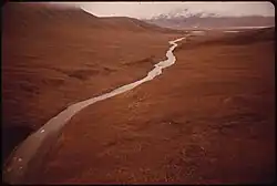 Atigun River flowing towards the mouth of Atigun Gorge (Dennis Cowals, 1973) | |
 Location in Alaska | |
| Physical characteristics | |
| Source | |
| • coordinates | 68°07′19″N 149°27′33″W / 68.1219444°N 149.4591667°W |
| Mouth | |
• coordinates | 68°31′31″N 149°00′12″W / 68.5252778°N 149.0033333°W |
• elevation | 621 meters |
| Length | 45 miles |
| Basin features | |
| River system | Sagavanirktok River |
The Atigun River (/ˈætəɡən/) is a river in the Endicott Mountains in northern Alaska, United States. The source is a glacier terminus, from which it flows northeast to the Sagavanirktok River 20 miles south of its junction with the Ribdon River. It is 45 miles long.[1]
References
- ^ "GNIS Detail - Atigun River". geonames.usgs.gov. Retrieved 27 December 2020.