Foel Rhudd
| Foel Rhudd | |
|---|---|
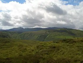 Foel Rhudd, Esgeiriau Gwynion and Llechwedd Du (right) with the Aran Fawddwy ridge (behind) from Moel y Cerrig Duon | |
| Highest point | |
| Elevation | 659 m (2,162 ft) |
| Prominence | 15 m (49 ft) |
| Parent peak | Esgeiriau Gwynion |
| Listing | Nuttall |
| Naming | |
| Language of name | Welsh |
| Geography | |
| Location | Gwynedd, Wales |
| Parent range | Aran Fawddwy |
| OS grid | SH 89585 23951 |
| Topo map | OS Landranger 125 |
Foel Rhudd is a top of Esgeiriau Gwynion in north Wales. It top a wide area of peat bog, the summit marked only by a few stones. Esgeiriau Gwynion summit is directly to the west, separated by a small col of peat hags. Llechwedd Du is connected to the south by a small ridge.[1]
References
52°48′7″N 3°38′22″W / 52.80194°N 3.63944°W