Fritzens
Fritzens | |
|---|---|
 | |
 Coat of arms | |
 Location in the district | |
 Fritzens Location within Austria | |
| Coordinates: 47°18′19″N 11°35′25″E / 47.30528°N 11.59028°E | |
| Country | Austria |
| State | Tyrol |
| District | Innsbruck Land |
| Government | |
| • Mayor | Josef Gahr (Fritzner Gemeindeliste) |
| Area | |
• Total | 6.14 km2 (2.37 sq mi) |
| Elevation | 591 m (1,939 ft) |
| Population (2018-01-01)[2] | |
• Total | 2,148 |
| • Density | 350/km2 (910/sq mi) |
| Time zone | UTC+1 (CET) |
| • Summer (DST) | UTC+2 (CEST) |
| Postal code | 6122 |
| Area code | 05224 |
| Vehicle registration | IL |
| Website | www.fritzens.tirol.gv.at |
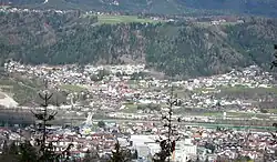
Fritzens is a municipality in the district Innsbruck country in Tyrol (Austria). It lies 16 km east of Innsbruck on the north side of the Inn River. The Iron Age Fritzens-Sanzeno culture is named for archaeological finds from the village.
Population
| Year | Pop. | ±% |
|---|---|---|
| 1869 | 234 | — |
| 1880 | 243 | +3.8% |
| 1890 | 259 | +6.6% |
| 1900 | 281 | +8.5% |
| 1910 | 365 | +29.9% |
| 1923 | 410 | +12.3% |
| 1934 | 602 | +46.8% |
| 1939 | 621 | +3.2% |
| 1951 | 812 | +30.8% |
| 1961 | 1,381 | +70.1% |
| 1971 | 1,714 | +24.1% |
| 1981 | 1,688 | −1.5% |
| 1991 | 1,848 | +9.5% |
| 2001 | 2,022 | +9.4% |
| 2011 | 2,063 | +2.0% |
| 2015 | 2,091 | +1.4% |
References
- ^ "Dauersiedlungsraum der Gemeinden Politischen Bezirke und Bundesländer - Gebietsstand 1.1.2018". Statistics Austria. Retrieved 10 March 2019.
- ^ "Einwohnerzahl 1.1.2018 nach Gemeinden mit Status, Gebietsstand 1.1.2018". Statistics Austria. Retrieved 9 March 2019.
External links
- Municipality Fritzens: Official website of the municipality in the Hall-Wattens region
Wikimedia Commons has media related to Fritzens.