Lakerveld
Lakerveld | |
|---|---|
Hamlet | |
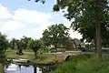
 Bridge at Lakerveld | |
 Lakerveld Location in the Netherlands  Lakerveld Lakerveld (Netherlands) | |
| Coordinates: 51°57′42″N 5°1′8″E / 51.96167°N 5.01889°E | |
| Country | Netherlands |
| Province | Utrecht |
| Municipality | Vijfheerenlanden |
| Area | |
• Total | 8.86 km2 (3.42 sq mi) |
| Population (2021)[1] | |
• Total | 355 |
| • Density | 40/km2 (100/sq mi) |
| Time zone | UTC+1 (CET) |
| • Summer (DST) | UTC+2 (CEST) |
| Postal code | 4128[1] |
| Dialing code | 0347 |
Lakerveld is a hamlet in the Dutch province of Utrecht. It is a part of the municipality of Vijfheerenlanden, and lies about 9 km south of IJsselstein.
The hamlet was first mentioned in the 16th century as Laeckervelt, and means "field near the Laak (river)".[2] Lakerveld has no place name signs. In 1840, it was home to 300 people.[3]
Gallery
-
 Windmill
 -
 Farm in Lakerveld
 -
 View on Lakerveld
 -
 Landscape near Lakerveld
References
- ^ a b c "Kerncijfers wijken en buurten 2021". Central Bureau of Statistics. Retrieved 27 March 2022.
- ^ "Lakerveld - (geografische naam)". Etymologiebank (in Dutch). Retrieved 27 March 2022.
- ^ "Lakerveld". Plaatsengids (in Dutch). Retrieved 27 March 2022.
Wikimedia Commons has media related to Lakerveld.