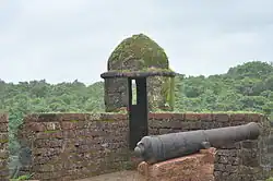
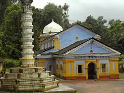
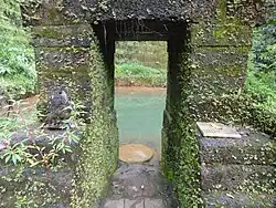
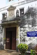
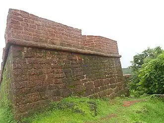
SL. No. Description Location Address District Coordinates Image S-GA-1 Site where the ancient image of Buddha was discovered at Colvale Bardez Upload Photo S-GA-2 Fortress of Colvale Bardez 15°38′06″N 73°51′02″E / 15.63493°N 73.85062°E / 15.63493; 73.85062 (SL. No. S-GA-2 ) Upload Photo S-GA-3 Reis Magos Fort Bardez 15°29′47″N 73°48′33″E / 15.49642°N 73.80918°E / 15.49642; 73.80918 (SL. No. S-GA-3 ) Reis Magos FortMore images S-GA-4 Church of Reis Magos Bardez 15°29′52″N 73°48′33″E / 15.4978°N 73.80918°E / 15.4978; 73.80918 (SL. No. S-GA-4 ) Church of Reis Magos S-GA-5 Chapora Fort Bardez 15°36′19″N 73°44′12″E / 15.60528°N 73.73675°E / 15.60528; 73.73675 (SL. No. S-GA-5 ) Chapora Fort S-GA-6 The Fortress of Khorjuve Bardez 15°35′48″N 73°53′34″E / 15.5968°N 73.89278°E / 15.5968; 73.89278 (SL. No. S-GA-6 ) Upload Photo S-GA-7 Cabo de Rama Fort Canacona 15°05′20″N 73°55′18″E / 15.08878°N 73.92159°E / 15.08878; 73.92159 (SL. No. S-GA-7 ) Upload Photo S-GA-8 Caves at Naroa Bicholim 15°33′19″N 73°56′06″E / 15.55531°N 73.93498°E / 15.55531; 73.93498 (SL. No. S-GA-8 ) Upload Photo S-GA-9 Temples of Saptakoteshwar Bicholim 15°33′15″N 73°56′14″E / 15.55421°N 73.93715°E / 15.55421; 73.93715 (SL. No. S-GA-9 ) Temples of Saptakoteshwar More images S-GA-10 Site of Gujir Bicholim 15°32′42″N 74°00′27″E / 15.54506°N 74.00737°E / 15.54506; 74.00737 (SL. No. S-GA-10 ) Upload Photo S-GA-11 Fort of Sanquelim Bicholim 15°34′00″N 74°00′25″E / 15.56678°N 74.00683°E / 15.56678; 74.00683 (SL. No. S-GA-11 ) Upload Photo S-GA-12 Namazgah Bicholim 15°34′57″N 73°56′46″E / 15.58246°N 73.94611°E / 15.58246; 73.94611 (SL. No. S-GA-12 ) Upload Photo S-GA-13 The Cave of Sidhanath at Tar Surla Bicholim 15°29′59″N 74°01′28″E / 15.49963°N 74.02458°E / 15.49963; 74.02458 (SL. No. S-GA-13 ) Upload Photo S-GA-14 The Mosque and Tank at Tar Surla Bicholim 15°29′51″N 74°01′07″E / 15.49762°N 74.01859°E / 15.49762; 74.01859 (SL. No. S-GA-14 ) Upload Photo S-GA-15 The Fort of Marmagoa Marmagoa 15°24′42″N 73°47′39″E / 15.41173°N 73.79417°E / 15.41173; 73.79417 (SL. No. S-GA-15 ) Upload Photo S-GA-16 The Site of Kaivailya Math at Consua Marmagoa 15°22′18″N 73°55′28″E / 15.37163°N 73.92445°E / 15.37163; 73.92445 (SL. No. S-GA-16 ) Upload Photo S-GA-17 Frontispices of Sancoale Mormugao 15°24′23″N 73°53′35″E / 15.40639°N 73.89316°E / 15.40639; 73.89316 (SL. No. S-GA-17 ) Frontispices of Sancoale S-GA-18 Shri Saptakoteshwar Ponda 15°25′10″N 74°02′53″E / 15.41956°N 74.04794°E / 15.41956; 74.04794 (SL. No. S-GA-18 ) Upload Photo S-GA-19 Shri Mahadev Temple Ponda 15°26′42″N 73°57′59″E / 15.4449°N 73.96638°E / 15.4449; 73.96638 (SL. No. S-GA-19 ) Shri Mahadev Temple S-GA-20 Ruins of Jain Basti Ponda 15°24′21″N 73°59′00″E / 15.40589°N 73.98325°E / 15.40589; 73.98325 (SL. No. S-GA-20 ) Upload Photo S-GA-21 Fort of Alorna Pernem 15°42′01″N 73°54′19″E / 15.70017°N 73.90538°E / 15.70017; 73.90538 (SL. No. S-GA-21 ) Upload Photo S-GA-22 Fort of Terekhol Pernem 15°43′17″N 73°41′12″E / 15.72139°N 73.68656°E / 15.72139; 73.68656 (SL. No. S-GA-22 ) Fort of Terekhol S-GA-23 Caves at Khandepar Ponda 15°25′45″N 74°02′59″E / 15.42917°N 74.0498°E / 15.42917; 74.0498 (SL. No. S-GA-23 ) Upload Photo S-GA-24 Cave at Ishwarbhat Ponda 15°26′36″N 74°02′28″E / 15.4434°N 74.04105°E / 15.4434; 74.04105 (SL. No. S-GA-24 ) Upload Photo S-GA-25 Cave at Mangeshi Ponda 15°27′17″N 73°57′58″E / 15.45474°N 73.96616°E / 15.45474; 73.96616 (SL. No. S-GA-25 ) Cave at Mangeshi More images S-GA-26 Shri Nagesh Temple Ponda 15°24′27″N 73°59′01″E / 15.40746°N 73.9837°E / 15.40746; 73.9837 (SL. No. S-GA-26 ) Shri Nagesh Temple More images S-GA-27 Shri Kamakshi Temple Ponda 15°19′15″N 74°02′05″E / 15.32091°N 74.0348°E / 15.32091; 74.0348 (SL. No. S-GA-27 ) Shri Kamakshi Temple More images S-GA-28 Shri Chandranath Paroda Quepem 15°12′48″N 74°02′12″E / 15.21342°N 74.03656°E / 15.21342; 74.03656 (SL. No. S-GA-28 ) Upload Photo S-GA-29 Site of Rock Carvings of Kazur Quepem 15°04′42″N 74°09′41″E / 15.07847°N 74.16138°E / 15.07847; 74.16138 (SL. No. S-GA-29 ) Upload Photo S-GA-30 Site of Ruins of Mangueshi Temple Salcete 15°23′21″N 73°55′15″E / 15.38905°N 73.9208°E / 15.38905; 73.9208 (SL. No. S-GA-30 ) Site of Ruins of Mangueshi Temple S-GA-31 Site of Ruins of Shanta Durga Temple Salcete 15°23′15″N 73°56′19″E / 15.38762°N 73.93851°E / 15.38762; 73.93851 (SL. No. S-GA-31 ) Site of Ruins of Shanta Durga Temple More images S-GA-32 Site – Ruins of Ramnath Temple Salcete 15°20′32″N 73°58′50″E / 15.3422°N 73.98063°E / 15.3422; 73.98063 (SL. No. S-GA-32 ) Upload Photo S-GA-33 Ruins including Tank of the Temple of Mahalsa Salcete 15°21′33″N 73°56′39″E / 15.35928°N 73.94419°E / 15.35928; 73.94419 (SL. No. S-GA-33 ) Upload Photo S-GA-34 Gate of Rachol Fortress Salcete 15°18′31″N 74°00′03″E / 15.30854°N 74.00089°E / 15.30854; 74.00089 (SL. No. S-GA-34 ) Upload Photo S-GA-35 Caves of Aquem Salcete 15°16′21″N 73°58′15″E / 15.27254°N 73.97079°E / 15.27254; 73.97079 (SL. No. S-GA-35 ) Upload Photo S-GA-36 Caves at Rivona Sanguem 15°09′41″N 74°06′37″E / 15.16128°N 74.11016°E / 15.16128; 74.11016 (SL. No. S-GA-36 ) Upload Photo S-GA-37 Site of Rock Carving at Pansaimal / Usgalimal Sanguem 15°07′15″N 74°07′59″E / 15.12083°N 74.13306°E / 15.12083; 74.13306 (SL. No. S-GA-37 ) Site of Rock Carving at Pansaimal / Usgalimal S-GA-38 The Cave at Shigao Sanguem 15°19′51″N 74°12′03″E / 15.33083°N 74.20095°E / 15.33083; 74.20095 (SL. No. S-GA-38 ) Upload Photo S-GA-39 The site of Narayandev at Vichundre Sanguem 15°06′06″N 74°11′36″E / 15.10177°N 74.19339°E / 15.10177; 74.19339 (SL. No. S-GA-39 ) Upload Photo S-GA-40 Ruins of Brahmapuri Tiswadi 15°29′24″N 73°54′58″E / 15.48987°N 73.91601°E / 15.48987; 73.91601 (SL. No. S-GA-40 ) Upload Photo S-GA-41 Chapel of St. Xavier Tiswadi 15°30′03″N 73°55′09″E / 15.50075°N 73.91922°E / 15.50075; 73.91922 (SL. No. S-GA-41 ) Chapel of St. Xavier S-GA-42 Chapel of Our Lady of the Mount Tiswadi 15°30′16″N 73°55′24″E / 15.50446°N 73.92332°E / 15.50446; 73.92332 (SL. No. S-GA-42 ) Chapel of Our Lady of the Mount S-GA-43 Convent of St. Monica and Chapel Tiswadi 15°30′05″N 73°54′27″E / 15.50138°N 73.9075°E / 15.50138; 73.9075 (SL. No. S-GA-43 ) Convent of St. Monica and Chapel S-GA-44 Ruins of College of St. Populo Tiswadi 15°29′55″N 73°54′21″E / 15.49869°N 73.90596°E / 15.49869; 73.90596 (SL. No. S-GA-44 ) Upload Photo S-GA-45 Church of St. Peter Tiswadi 15°30′01″N 73°53′50″E / 15.5003°N 73.89724°E / 15.5003; 73.89724 (SL. No. S-GA-45 ) Church of St. Peter S-GA-46 Casa da Polvora Tiswadi 15°30′10″N 73°54′37″E / 15.50282°N 73.91023°E / 15.50282; 73.91023 (SL. No. S-GA-46 ) Upload Photo S-GA-47 Fort Naroa Tiswadi 15°32′17″N 73°55′20″E / 15.53809°N 73.92218°E / 15.53809; 73.92218 (SL. No. S-GA-47 ) Fort Naroa S-GA-48 Site of the Temple of Saptakoteshwar Tiswadi 15°31′53″N 73°55′34″E / 15.53128°N 73.9262°E / 15.53128; 73.9262 (SL. No. S-GA-48 ) Upload Photo S-GA-49 Chapel of St. Jeronimus Tiswadi 15°31′38″N 73°52′39″E / 15.52726°N 73.87747°E / 15.52726; 73.87747 (SL. No. S-GA-49 ) Upload Photo S-GA-50 British Cemetery at Dona Paula Tiswadi 15°27′30″N 73°47′52″E / 15.45823°N 73.7977°E / 15.45823; 73.7977 (SL. No. S-GA-50 ) British Cemetery at Dona Paula S-GA-51 The Site of Fortress at St Estevam Tiswadi 15°32′10″N 73°57′16″E / 15.53601°N 73.95435°E / 15.53601; 73.95435 (SL. No. S-GA-51 ) The Site of Fortress at St Estevam