This is a list of listed buildings in the parish of Aberchirder in Aberdeenshire, Scotland.
List
| Name | Location | Date Listed | Grid Ref. [note 1] | Geo-coordinates | Notes | LB Number [note 2] | Image |
| Main Street, Bank House and Clydesdale Bank | | | | 57°33′36″N 2°37′49″W / 57.559972°N 2.630181°W / 57.559972; -2.630181 (Main Street, Bank House and Clydesdale Bank) | Category B | 19913 | .jpg) Upload another image
|
| 137 Main Street with Boundary Wall | | | | 57°33′42″N 2°37′29″W / 57.56167°N 2.624812°W / 57.56167; -2.624812 (137 Main Street with Boundary Wall) | Category C(S) | 19915 | 
Upload Photo |
| 18 and 19 The Square | | | | 57°33′38″N 2°37′45″W / 57.560463°N 2.629103°W / 57.560463; -2.629103 (18 and 19 The Square) | Category B | 19934 |
Upload Photo |
| 30 and 32 Main Street | | | | 57°33′34″N 2°37′52″W / 57.559474°N 2.631042°W / 57.559474; -2.631042 (30 and 32 Main Street) | Category C(S) | 19918 |
Upload Photo |
| South Street, Gowanlea with Boundary Wall and Railings | | | | 57°33′40″N 2°37′18″W / 57.56112°N 2.621644°W / 57.56112; -2.621644 (South Street, Gowanlea with Boundary Wall and Railings) | Category C(S) | 19923 |
Upload Photo |
| 7 South Street | | | | 57°33′32″N 2°37′47″W / 57.558762°N 2.629776°W / 57.558762; -2.629776 (7 South Street) | Category C(S) | 19926 |
Upload Photo |
| Rear, 19 and 20 South Street | | | | 57°33′33″N 2°37′43″W / 57.559271°N 2.628598°W / 57.559271; -2.628598 (Rear, 19 and 20 South Street) | Category C(S) | 19927 |
Upload Photo |
| The Square, Victoria Fountain | | | | 57°33′37″N 2°37′43″W / 57.560213°N 2.628731°W / 57.560213; -2.628731 (The Square, Victoria Fountain) | Category C(S) | 19932 | 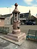 Upload another image
|
| Main Street, New Marnoch Church (Church Of Scotland) with Boundary Wall | | | | 57°33′44″N 2°37′20″W / 57.562168°N 2.622146°W / 57.562168; -2.622146 (Main Street, New Marnoch Church (Church Of Scotland) with Boundary Wall) | Category B | 19914 | .jpg) Upload another image
|
| Main Street, Woodside Cottage | | | | 57°33′32″N 2°37′58″W / 57.559007°N 2.632872°W / 57.559007; -2.632872 (Main Street, Woodside Cottage) | Category C(S) | 19917 |
Upload Photo |
| North Street, Steading | | | | 57°33′36″N 2°37′48″W / 57.560117°N 2.630067°W / 57.560117; -2.630067 (North Street, Steading) | Category C(S) | 19919 |
Upload Photo |
| North Street, United Presbyterian Church | | | | 57°33′37″N 2°37′55″W / 57.560198°N 2.631823°W / 57.560198; -2.631823 (North Street, United Presbyterian Church) | Category C(S) | 19920 | .jpg) Upload another image
|
| St Marnan's Episcopal Chapel with School, Retaining Wall and Gatepiers | | | | 57°33′31″N 2°37′57″W / 57.558622°N 2.632631°W / 57.558622; -2.632631 (St Marnan's Episcopal Chapel with School, Retaining Wall and Gatepiers) | Category B | 19922 | .jpg) Upload another image
|
| 23 South Street | | | | 57°33′34″N 2°37′40″W / 57.559436°N 2.627782°W / 57.559436; -2.627782 (23 South Street) | Category B | 19928 |
Upload Photo |
| 51 South Street with Boundary Wall and Railings | | | | 57°33′40″N 2°37′22″W / 57.561123°N 2.62283°W / 57.561123; -2.62283 (51 South Street with Boundary Wall and Railings) | Category C(S) | 19929 |
Upload Photo |
| 148 Main Street | | | | 57°33′42″N 2°37′25″W / 57.561739°N 2.623559°W / 57.561739; -2.623559 (148 Main Street) | Category C(S) | 19916 |
Upload Photo |
| South Street, Laurelbank | | | | 57°33′40″N 2°37′17″W / 57.561202°N 2.621344°W / 57.561202; -2.621344 (South Street, Laurelbank) | Category C(S) | 19925 |
Upload Photo |
| 10 South Street | | | | 57°33′32″N 2°37′45″W / 57.558944°N 2.629194°W / 57.558944; -2.629194 (10 South Street) | Category B | 19930 |
Upload Photo |
| 12 The Square | | | | 57°33′36″N 2°37′45″W / 57.560013°N 2.629279°W / 57.560013; -2.629279 (12 The Square) | Category C(S) | 19933 |
Upload Photo |
| South Street, Kinnairdy Lodge with Boundary Wall and Railings | | | | 57°33′40″N 2°37′19″W / 57.56102°N 2.621809°W / 57.56102; -2.621809 (South Street, Kinnairdy Lodge with Boundary Wall and Railings) | Category C(S) | 19924 |
Upload Photo |
| 38 South Street | | | | 57°33′36″N 2°37′31″W / 57.560095°N 2.62537°W / 57.560095; -2.62537 (38 South Street) | Category B | 19931 |
Upload Photo |
| 69 North Street | | | | 57°33′40″N 2°37′45″W / 57.560984°N 2.629029°W / 57.560984; -2.629029 (69 North Street) | Category C(S) | 19921 |
Upload Photo |
Key
The scheme for classifying buildings in Scotland is:
- Category A: "buildings of national or international importance, either architectural or historic; or fine, little-altered examples of some particular period, style or building type."[1]
- Category B: "buildings of regional or more than local importance; or major examples of some particular period, style or building type, which may have been altered."[1]
- Category C: "buildings of local importance; lesser examples of any period, style, or building type, as originally constructed or moderately altered; and simple traditional buildings which group well with other listed buildings."[1]
In March 2016 there were 47,288 listed buildings in Scotland. Of these, 8% were Category A, and 50% were Category B, with the remaining 42% being Category C.[2]
See also
Notes
References