List of listed buildings in Dundee/1
This is a list of listed buildings in Dundee, Scotland.
List
| Name | Location | Date Listed | Grid Ref. [note 1] | Geo-coordinates | Notes | LB Number [note 2] | Image |
|---|---|---|---|---|---|---|---|
| West Ferry, 20 Douglas Terrace, Formerly West Ferry Station | 56°28′08″N 2°53′13″W / 56.468822°N 2.886938°W | Category B | 25921 |  Upload Photo | |||
| West Ferry, 75 Dundee Road, Including Gatepiers And Wall Extending To 73 Dundee Road | 56°28′09″N 2°54′05″W / 56.469257°N 2.901411°W | Category B | 25924 | Upload Photo | |||
| West Ferry, 96 Dundee Road, St Stephen's And West Church, Including Enclosing Wall, Gatepiers And Dies | 56°28′05″N 2°52′55″W / 56.468014°N 2.881807°W | Category A | 25932 | .jpg) | |||
| West Ferry, 7 Fairfield Road, Fairfield, Including Coach House, Lamp Standard, Wall And Gatepiers | 56°28′12″N 2°54′03″W / 56.470042°N 2.900959°W | Category B | 25936 | Upload Photo | |||
| West Ferry, 17 Fairfield Road, Red Court Lodge | 56°28′17″N 2°54′05″W / 56.471279°N 2.901329°W | Category B | 25939 | Upload Photo | |||
| West Ferry 48 Victoria Road And 129 Strathearn Road, Hermon Lodge, Including Conservatory, Gatepiers And Boundary Wall | 56°28′23″N 2°53′11″W / 56.473139°N 2.886325°W | Category B | 25953 | Upload Photo | |||
| Broughty Ferry, 155-159 (Odd Nos) King Street, The Eagle Inn | 56°27′58″N 2°52′35″W / 56.46613°N 2.876391°W | Category B | 25844 | Upload Photo | |||
| 337, 339 King Street And 69-77 (Odd Nos) St Vincent Street, Ramsay Place | 56°27′56″N 2°52′15″W / 56.465523°N 2.870729°W | Category C(S) | 25845 | Upload Photo | |||
| Broughty Ferry, 375, 377 King Street, With Enclosing Walls | 56°27′54″N 2°52′11″W / 56.465117°N 2.869584°W | Category C(S) | 25847 | Upload Photo | |||
| Broughty Ferry, 140-144 (Even Nos) King Street | 56°27′58″N 2°52′38″W / 56.465981°N 2.877166°W | Category C(S) | 25849 | Upload Photo | |||
| Broughty Ferry, 14 Monifieth Road, Walnut Cottage, Including Gateposts And Enclosing Wall | 56°28′03″N 2°52′05″W / 56.467428°N 2.868143°W | Category C(S) | 25859 | Upload Photo | |||
| Broughty Ferry, 94 Monifieth Road, Armistead Lodge, Including Wall And Gatepiers | 56°28′12″N 2°51′18″W / 56.470016°N 2.85512°W | Category C(S) | 25861 | Upload Photo | |||
| Broughty Ferry, 7, 9, 11 And 13 Norrie Street, Including Boundary Wall And Gatepiers | 56°28′08″N 2°51′53″W / 56.468871°N 2.864703°W | Category C(S) | 25863 | Upload Photo | |||
| Broughty Ferry, 15 Norrie Street, Craigruach, Including Gatepiers And Adjoining Walls | 56°28′09″N 2°51′53″W / 56.469167°N 2.864855°W | Category B | 25864 | Upload Photo | |||
| Broughty Ferry, 13-21 (Odd Nos) Queen Street, Including Boundary Wall | 56°28′09″N 2°52′50″W / 56.469219°N 2.880455°W | Category B | 25865 | Upload Photo | |||
| Broughty Ferry, 2-8 (Even Nos) Queen Street, (And 4 Claypotts Road) Including Boundary Wall | 56°28′08″N 2°52′50″W / 56.468921°N 2.880562°W | Category B | 25868 | Upload Photo | |||
| Broughty Ferry, 160 St Vincent Street | 56°28′00″N 2°52′10″W / 56.466708°N 2.869571°W | Category C(S) | 25878 | Upload Photo | |||
| Broughty Ferry, 45 Seafield Road, Mount Rosa, Including Conservatory, 3 Pairs Of Gatepiers And Boundary Wall | 56°28′22″N 2°52′43″W / 56.472871°N 2.87851°W | Category B | 25881 | Upload Photo | |||
| Broughty Ferry, 18 Westfield Road And 9 King Street | 56°28′01″N 2°52′53″W / 56.466867°N 2.881391°W | Category B | 25883 | Upload Photo | |||
| Broughty Ferry, Westfield Road, Our Lady Of Good Counsel Roman Catholic Church | 56°28′02″N 2°52′52″W / 56.467291°N 2.881076°W | Category C(S) | 25884 | Upload Photo | |||
| Pitkerro Lodge, Pitkerro Lodge, Including Gatepiers And Gates | 56°29′23″N 2°53′23″W / 56.489762°N 2.889782°W | Category A | 25894 | Upload Photo | |||
| West Ferry, 5 Albany Road And 36 Strathern Road, The Croft, Including Wall And Gatepiers | 56°28′17″N 2°54′19″W / 56.471367°N 2.905259°W | Category B | 25902 | Upload Photo | |||
| West Ferry, 37, 39, 41, 43 Albert Road, Taymount, Including Summerhouse And Lamp Standards | 56°28′16″N 2°52′54″W / 56.471231°N 2.881751°W | Category B | 25908 | Upload Photo | |||
| West Ferry, 1 Balmyle Road, Balmyle, Including Motor House/Garage, Gatepiers And Boundary Walls | 56°28′13″N 2°53′29″W / 56.470336°N 2.891324°W | Category B | 25909 | Upload Photo | |||
| Broughty Ferry, 20 Camphill Road, With Gatepiers | 56°28′08″N 2°52′11″W / 56.468791°N 2.869781°W | Category C(S) | 25780 | Upload Photo | |||
| Broughty Ferry, 50 Camphill Road, Camphill House, (Entry From 8 Norrie Street) | 56°28′10″N 2°51′57″W / 56.469484°N 2.865707°W | Category B | 25784 | Upload Photo | |||
| Broughty Ferry 61-69 (Odd Nos) Castle Street, Salisbury Place Including Enclosing Wall | 56°27′57″N 2°51′53″W / 56.465745°N 2.864648°W | Category C(S) | 25787 | Upload Photo | |||
| Broughty Ferry, 2 Dalhouse Road And 2, 4 And 6 Shiell Street, Including Outbuilding Game Larder, Boundary_Walls And Gatepiers (Formerly Abertay House) | 56°28′15″N 2°51′07″W / 56.470846°N 2.851989°W | Category B | 25790 | Upload Photo | |||
| Broughty Ferry, 1-5 (Inclusive) East Links Place | 56°27′58″N 2°51′50″W / 56.466064°N 2.864006°W | Category C(S) | 25792 | Upload Photo | |||
| Broughty Ferry, 57 Fisher Street, Ann Cottage | 56°27′55″N 2°52′43″W / 56.465351°N 2.878483°W | Category C(S) | 25794 | Upload Photo | |||
| Broughty Ferry, 109 Fisher Street And 4 Fort Street | 56°27′54″N 2°52′37″W / 56.465128°N 2.877001°W | Category C(S) | 25799 | 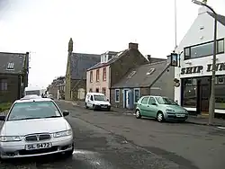 | |||
| Broughty Ferry, 183 Fisher Street | 56°27′54″N 2°52′30″W / 56.465079°N 2.875052°W | Category C(S) | 25803 | Upload Photo | |||
| Broughty Ferry, 207 Fisher Street And 5-11 (Odd Nos) Gray Street | 56°27′55″N 2°52′27″W / 56.465175°N 2.874243°W | Category C(S) | 25804 | Upload Photo | |||
| Broughty Ferry, 32 And 34 Fort Street | 56°27′57″N 2°52′36″W / 56.465732°N 2.876723°W | Category B | 25814 | Upload Photo | |||
| Broughty Ferry, 80 Forthill Road, Red Cottage, Including Boundary Walls | 56°28′28″N 2°52′27″W / 56.474349°N 2.874032°W | Category B | 25820 | Upload Photo | |||
| Broughty Ferry, 85, 87 And 89 Gray Street, Clydesdale Bank | 56°28′01″N 2°52′25″W / 56.466824°N 2.873502°W | Category C(S) | 25822 | Upload Photo | |||
| Broughty Ferry, The Harbour, 3 Lampstandards | 56°27′50″N 2°52′14″W / 56.463799°N 2.87056°W | Category B | 25831 | Upload Photo | |||
| Broughty Ferry, 1 Hill Street, St Margaret's Including Wall And Gatepiers | 56°28′11″N 2°52′29″W / 56.469835°N 2.874593°W | Category C(S) | 25833 | Upload Photo | |||
| 48 And 48A Roseangle, Including Garden Walls | 56°27′13″N 2°59′08″W / 56.453666°N 2.985654°W | Category C(S) | 25674 | Upload Photo | |||
| Springfield 1-32 (Inclusive Nos) | 56°27′24″N 2°59′09″W / 56.456656°N 2.985958°W | Category A | 25678 | Upload Photo | |||
| 11 Step Row, Former Dundee Rope Works Tar House | 56°27′20″N 2°59′32″W / 56.455438°N 2.992141°W | Category B | 25679 | Upload Photo | |||
| 1-28 (Inclusive Nos) Windsor Street | 56°27′18″N 2°59′51″W / 56.455027°N 2.997501°W | Category B | 25688 | Upload Photo | |||
| Broughty Ferry, Beach Crescent, K6 Telephone Kiosk | 56°27′54″N 2°52′26″W / 56.464943°N 2.873962°W | Category B | 25732 | Upload Photo | |||
| Baldovie, Road Bridge Over Fithie Burn | 56°29′19″N 2°53′38″W / 56.488718°N 2.893817°W | Category B | 25736 | Upload Photo | |||
| Barnhill, 2 Panmure Terrace, Longcroft, Including Myrtle Cottage | 56°28′22″N 2°51′10″W / 56.472852°N 2.852878°W | Category B | 25748 | Upload Photo | |||
| Broughty Ferry, 19 Ambrose Street | 56°27′56″N 2°52′31″W / 56.465508°N 2.875305°W | Category C(S) | 25755 | Upload Photo | |||
| 2-8 (Even Nos) Perth Road | 56°27′24″N 2°58′42″W / 56.456634°N 2.978461°W | Category B | 25581 | Upload Photo | |||
| 36-42 (Even Nos) Union Street | 56°27′32″N 2°58′14″W / 56.458997°N 2.970441°W | Category B | 25594 | Upload Photo | |||
| 44-50 (Even Nos) Union Street | 56°27′32″N 2°58′13″W / 56.458836°N 2.970372°W | Category B | 25596 | Upload Photo | |||
| 7-13 (Odd Nos) Well Road, Including Boundary Wall And Gatepiers | 56°27′27″N 2°59′08″W / 56.45762°N 2.985594°W | Category B | 25620 | Upload Photo | |||
| 1 West Bell Street, Including Railings | 56°27′45″N 2°58′31″W / 56.46248°N 2.975399°W | Category B | 25624 | Upload Photo | |||
| 3, 5, 7 West Bell Street, Curr Centre, Including Railings | 56°27′45″N 2°58′33″W / 56.462405°N 2.97577°W | Category B | 25627 | Upload Photo | |||
| 9 West Bell Street, Including Railings | 56°27′44″N 2°58′34″W / 56.462332°N 2.976011°W | Category B | 25629 | Upload Photo | |||
| 2-16 (Even Nos) West Port, 52-58 (Even Nos) South Tay Street | 56°27′33″N 2°58′40″W / 56.459299°N 2.977735°W | Category B | 25635 | Upload Photo | |||
| 512 Perth Road Dunholm, With Gatepiers And Boundary Wall | 56°27′23″N 3°01′16″W / 56.456363°N 3.021016°W | Category C(S) | 25638 | Upload Photo | |||
| 514 Perth Road Nyoora, With Garden Walls And Gatepiers | 56°27′23″N 3°01′17″W / 56.456433°N 3.021309°W | Category B | 25640 | Upload Photo | |||
| 516 Perth Road, Ardvreck, With Boundary Walls And Gatepiers | 56°27′23″N 3°01′21″W / 56.456397°N 3.022379°W | Category B | 25642 | Upload Photo | |||
| 2-18 (Even Nos) Pitfour Street | 56°27′51″N 2°59′53″W / 56.464177°N 2.998115°W | Category B | 25644 | Upload Photo | |||
| 2-8 (Even Nos) Whitehall Crescent, 14 And 15 Dock Street | 56°27′33″N 2°58′08″W / 56.459252°N 2.968841°W | Category B | 25645 | Upload Photo | |||
| 1 And 3 Whitehall Street, 8 Nethergate, Blakeney's Buildings | 56°27′35″N 2°58′16″W / 56.459631°N 2.970993°W | Category B | 25657 | Upload Photo | |||
| 2 Roseangle, Including Railings And Gates To Street And Garden Walls | 56°27′22″N 2°58′53″W / 56.456233°N 2.981437°W | Category B | 25660 | Upload Photo | |||
| 38, 40 Whitehall Street, Kimberley Buildings | 56°27′34″N 2°58′11″W / 56.459442°N 2.969852°W | Category B | 25671 | Upload Photo | |||
| 1-63 (Odd Nos) Reform Street | 56°27′43″N 2°58′17″W / 56.461882°N 2.97144°W | Category B | 25519 | Upload Photo | |||
| 16-32 (Even Nos) Reform Street | 56°27′40″N 2°58′16″W / 56.461103°N 2.971144°W | Category B | 25528 | Upload Photo | |||
| 78-86 (Even Nos) Victoria Road And 2, 4 Forebank Road | 56°27′57″N 2°58′06″W / 56.465762°N 2.968212°W | Category B | 25530 | Upload Photo | |||
| 227-229 Perth Road, Blackness Crescent Including Gatepiers And Boundary Walls | 56°27′24″N 2°59′48″W / 56.456742°N 2.99654°W | Category C(S) | 25534 | Upload Photo | |||
| 42-58 (Even Nos) Reform Street | 56°27′42″N 2°58′19″W / 56.461762°N 2.971956°W | Category B | 25535 | Upload Photo | |||
| Barrack Road And Dudhope Terrace, Caird Wing, Dundee Royal Infirmary | 56°27′58″N 2°58′54″W / 56.466177°N 2.981677°W | Category B | 25543 | Upload Photo | |||
| 30-34 (Even Nos) Seagate | 56°27′43″N 2°58′05″W / 56.461909°N 2.968081°W | Category B | 25544 | Upload Photo | |||
| 1-27 (Odd Nos) South Tay Street, 105-113, (Odd Nos) Nethergate, Including Railings, And Boundary Walls To Rear | 56°27′30″N 2°58′33″W / 56.458201°N 2.975776°W | Category A | 25546 | Upload Photo | |||
| 271-297 (Odd Numbers) Perth Road And 1 Rockfield Street, Clarendon Terrace, With Boundary Walls And Gatepiers | 56°27′24″N 3°00′08″W / 56.456785°N 3.002318°W | Category B | 25549 | Upload Photo | |||
| 37, 39 South Tay Street | 56°27′31″N 2°58′35″W / 56.458672°N 2.976372°W | Category B | 25552 | Upload Photo | |||
| 41, 43 South Tay Street | 56°27′32″N 2°58′35″W / 56.458752°N 2.976504°W | Category C(S) | 25554 | Upload Photo | |||
| 8, 9, 10, 11 Tay Square, 18 South Tay Street | 56°27′29″N 2°58′35″W / 56.458052°N 2.976453°W | Category B | 25570 | Upload Photo | |||
| 381 Perth Road, 2A, 2B, 2C And 4 Hazel Drive Duncarse House, Lodge, Boundary Walls, And Gatepiers | 56°27′29″N 3°01′36″W / 56.457987°N 3.026771°W | Category B | 25573 | Upload Photo | |||
| 84, 88, 90 Nethergate | 56°27′32″N 2°58′21″W / 56.458811°N 2.972465°W | Category B | 25425 | Upload Photo | |||
| Macalpine Road Dundee Crematorium With Gates, Pergola And Lodge | 56°29′08″N 3°00′20″W / 56.485491°N 3.005657°W | Category B | 25428 | 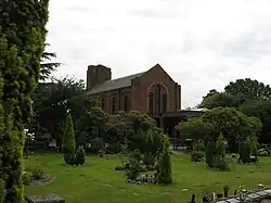 | |||
| 7, 9, 11 Madeira Street | 56°28′32″N 2°57′10″W / 56.475467°N 2.952841°W | Category B | 25432 | Upload Photo | |||
| 92-96 (Even Nos) Nethergate | 56°27′31″N 2°58′22″W / 56.458728°N 2.972657°W | Category B | 25433 | Upload Photo | |||
| 132, 132A, 134 Nethergate | 56°27′29″N 2°58′26″W / 56.458071°N 2.974004°W | Category B | 25444 | Upload Photo | |||
| 134A, 134B Nethergate | 56°27′28″N 2°58′26″W / 56.457892°N 2.97395°W | Category B | 25447 | Upload Photo | |||
| 2, 4, 6 Hyndford Street, And 40-44 Shaftesbury Road, Including Garden Walls | 56°27′26″N 3°00′07″W / 56.457084°N 3.002034°W | Category B | 25449 | Upload Photo | |||
| 136-148 (Even Nos), Nethergate, Including Remains Of Former Sea Wall To South | 56°27′28″N 2°58′29″W / 56.457644°N 2.974642°W | Category A | 25451 | Upload Photo | |||
| 1, 1A Magdalen Place, Magdalen House With Boundary Walls And Gatepiers | 56°27′13″N 2°59′12″W / 56.453749°N 2.986565°W | Category B | 25453 | Upload Photo | |||
| 160 Nethergate, Queen's Hotel, Including Lampstandards And Former Sea Wall | 56°27′25″N 2°58′34″W / 56.45695°N 2.975987°W | Category B | 25461 | Upload Photo | |||
| 164 Nethergate, Including Boundary Walls And Railings | 56°27′25″N 2°58′36″W / 56.456864°N 2.976682°W | Category B | 25467 | Upload Photo | |||
| 65 Magdalen Yard Road, With Gatepiers And Garden Walls | 56°27′13″N 2°59′31″W / 56.453588°N 2.992044°W | Category B | 25484 | Upload Photo | |||
| 1-9 (Inclusive) Trottick Mains | 56°29′31″N 2°58′19″W / 56.492031°N 2.971821°W | Category C(S) | 25497 | Upload Photo | |||
| 6 Union Terrace And 7 Constitution Terrace, With Boundary Walls And Gatepiers | 56°27′59″N 2°58′39″W / 56.466353°N 2.977575°W | Category C(S) | 25512 | Upload Photo | |||
| 10, 12, 14 Victoria Road, Victoria Chambers | 56°27′52″N 2°58′18″W / 56.46444°N 2.971765°W | Category B | 25518 | Upload Photo | |||
| 53, 55 Forfar Road, With Gatepiers Garden Walls, And Railings To Garages | 56°28′46″N 2°57′07″W / 56.47931°N 2.951964°W | Category B | 25311 | Upload Photo | |||
| 38, 40 Seagate, Former Robertson's Bond | 56°27′43″N 2°58′04″W / 56.462072°N 2.96789°W | Category B | 25325 | Upload Photo | |||
| 33, 35 Meadowside Or Albert Square | 56°27′46″N 2°58′12″W / 56.462864°N 2.969972°W | Category B | 25327 | Upload Photo | |||
| 41 High Street Lochee St Mary's Rc Church And Presbytery | 56°28′14″N 3°00′28″W / 56.470658°N 3.007813°W | Category A | 25338 | Upload Photo | |||
| Airlie Place 1-15 (Odd Numbers) Airlie Hall, Dundee University With Boundary Walls And Railings | 56°27′24″N 2°58′50″W / 56.456787°N 2.980688°W | Category B | 25341 | Upload Photo | |||
| 30 Meadowside, 2, 4 Royal Exchange Lane, Former Pearl Assurance Buildings | 56°27′48″N 2°58′15″W / 56.463334°N 2.97073°W | Category B | 25343 | Upload Photo | |||
| Airlie Place, 2-14 (Even Nos) Dundee University With Boundary Walls And Railings | 56°27′25″N 2°58′54″W / 56.456968°N 2.981715°W | Category B | 25344 | Upload Photo | |||
| 45, 47 High Street, Lochee And 2 St Mary's Lane, Public Library, Swimming And Leisure Centre | 56°28′16″N 3°00′31″W / 56.471047°N 3.008602°W | Category B | 25345 | Upload Photo | |||
| 12, 14 Murraygate | 56°27′44″N 2°58′09″W / 56.46218°N 2.969029°W | Category B | 25366 | Upload Photo | |||
| 124, 126 Blackness Road, Al-Maktoum Institute For Arabic And Islamic Studies (Former St Joseph's School) | 56°27′36″N 2°59′18″W / 56.460023°N 2.988431°W | Category B | 25384 | Upload Photo | |||
| 6, 8 Laurel Bank, And 5, 7 Prospect Place With Boundary Walls And Gatepiers | 56°27′55″N 2°58′36″W / 56.465362°N 2.976803°W | Category B | 25397 | Upload Photo | |||
| 11 Blinshall Street, Former St Mary Magdalene's Church (Episcopal) | 56°27′38″N 2°58′52″W / 56.460531°N 2.980996°W | Category B | 25400 | Upload Photo | |||
| 145 Nethergate | 56°27′27″N 2°58′35″W / 56.457496°N 2.976309°W | Category B | 25414 | Upload Photo | |||
| 1 Lawside Road | 56°28′01″N 2°59′33″W / 56.46689°N 2.992635°W | Category C(S) | 25417 | Upload Photo | |||
| 6 Dudhope Street And Boundary Walls | 56°27′54″N 2°58′34″W / 56.464955°N 2.97603°W | Category B | 25210 | Upload Photo | |||
| 106-116 (Even Nos) Cowgate Former Wishart Memorial Church And John O'Groats Bar | 56°27′54″N 2°57′49″W / 56.465124°N 2.963554°W | Category B | 25213 | Upload Photo | |||
| 1A And 2 High Street/2, 4, 6 Castle Street | 56°27′40″N 2°58′07″W / 56.461023°N 2.96874°W | Category B | 25219 | Upload Photo | |||
| 3, 4 High Street/1, 3, 5 Castle Street, Royal Bank Of Scotland | 56°27′39″N 2°58′08″W / 56.460725°N 2.968927°W | Category B | 25223 | Upload Photo | |||
| 36 Forebank Road, St Mary's Or Our Lady Of Victories, Rc Church | 56°28′02″N 2°58′15″W / 56.467144°N 2.970714°W | Category B | 25249 | Upload Photo | |||
| 1, 2 Forebank Terrace | 56°27′59″N 2°58′10″W / 56.466507°N 2.969415°W | Category C(S) | 25253 | Upload Photo | |||
| 11-13 (Inclusive Nos) City Square, 20-24 (Even Nos) Crichton Street, 1-7 (Inclusive Nos) Shore Terrace And Return To 35 Castle Street, Caird Hall | 56°27′35″N 2°58′08″W / 56.459603°N 2.968801°W | Category A | 25258 | .jpg) | |||
| 11 Dudhope Terrace | 56°27′58″N 2°59′07″W / 56.466139°N 2.985409°W | Category B | 25261 | Upload Photo | |||
| 12 Dudhope Terrace | 56°27′58″N 2°59′09″W / 56.466028°N 2.985796°W | Category B | 25265 | Upload Photo | |||
| 13 Dudhope Terrace | 56°27′57″N 2°59′10″W / 56.465935°N 2.986231°W | Category B | 25268 | Upload Photo | |||
| 14 Dudhope Terrace And 1, 3 Inverlaw Place, Including Former_Stables | 56°27′57″N 2°59′12″W / 56.465869°N 2.986619°W | Category B | 25272 | Upload Photo | |||
| Eliza Street, Clepington Primary School Former Stobswell Public School, Including Railings And Boundary Walls | 56°28′22″N 2°57′34″W / 56.472775°N 2.959446°W | Category A | 25280 | 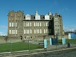 | |||
| Off Perth Road, Geddes Quadrangle, Peters Building, University Of Dundee | 56°27′27″N 2°58′52″W / 56.457539°N 2.981065°W | Category B | 25285 | Upload Photo | |||
| Small's Lane, Ewing Building, University Of Dundee, Including Boundary Walls, Railings, Gates And Gatepiers | 56°27′29″N 2°58′49″W / 56.458193°N 2.980173°W | Category B | 25296 | Upload Photo | |||
| 23-45 (Odd Nos) And 14-22 (Even Nos) Heron Rise, Claverhouse Road, Claverhouse Bleachfield, Former Beetling House, Office And Chimney Stalk (Tvj Ltd) | 56°29′31″N 2°57′46″W / 56.491887°N 2.962641°W | Category A | 25112 | Upload Photo | |||
| Claverhouse Road Bridge Over Dighty Water | 56°29′28″N 2°57′44″W / 56.491109°N 2.962215°W | Category B | 25130 | Upload Photo | |||
| 23-29 (Odd Nos) Crichton Street | 56°27′35″N 2°58′11″W / 56.459658°N 2.969793°W | Category C(S) | 25138 | Upload Photo | |||
| Clepington Road And Return To Stobsmuir Road, Stobsmuir Water Works | 56°28′38″N 2°57′07″W / 56.477299°N 2.951848°W | Category B | 25141 | Upload Photo | |||
| 20, 21, 22 Dock Street | 56°27′37″N 2°58′01″W / 56.460345°N 2.966905°W | Category B | 25154 | Upload Photo | |||
| 56-59 (Inclusive Nos) Dock Street | 56°27′42″N 2°57′53″W / 56.461539°N 2.96481°W | Category B | 25170 | Upload Photo | |||
| Court Street 1-23 (Odd Nos) "The Connies" | 56°28′27″N 2°57′47″W / 56.474256°N 2.963136°W | Category B | 25180 | Upload Photo | |||
| 4 Dudhope Street With Boundary Walls And Gatepiers | 56°27′54″N 2°58′35″W / 56.464863°N 2.976287°W | Category C(S) | 25206 | Upload Photo | |||
| Methven Street, Camperdown Works High Mill Or Sliver Mill | 56°28′21″N 3°00′25″W / 56.472525°N 3.00684°W | Category A | 25041 | Upload Photo | |||
| 133 Broughty Ferry Road Carolina House, Former Dundee Orphan Institution, With Railings | 56°28′06″N 2°56′13″W / 56.468222°N 2.936883°W | Category B | 25042 | Upload Photo | |||
| Byron Street Ss Peter And Paul Rc Primary School, Janitors House And Play Shelter | 56°28′24″N 2°58′52″W / 56.47344°N 2.981248°W | Category B | 25058 | Upload Photo | |||
| 23 Commercial Street | 56°27′40″N 2°58′01″W / 56.461244°N 2.966928°W | Category C(S) | 25059 | Upload Photo | |||
| 96 Byron Street Lawton Reservoir (Original Covered Reservoir, Cottage, Railings And Gates | 56°28′20″N 2°59′28″W / 56.472149°N 2.991051°W | Category B | 25062 | Upload Photo | |||
| 35-49 (Odd Nos) Commercial Street/1, 3, 5 Seagate | 56°27′41″N 2°58′03″W / 56.461418°N 2.96763°W | Category B | 25067 | Upload Photo | |||
| 51-65 (Odd Nos) Commercial Street/1, 3, 5 Murraygate/20-26 (Even Nos) Seagate | 56°27′42″N 2°58′06″W / 56.461762°N 2.968386°W | Category A | 25071 | Upload Photo | |||
| Camperdown Country Park Camperdown Dairy Cottage | 56°29′07″N 3°02′46″W / 56.485391°N 3.046039°W | Category C(S) | 25082 | Upload Photo | |||
| 18, 22-32 (Even Nos) Commercial Street, Calcutta Buildings | 56°27′39″N 2°58′01″W / 56.460947°N 2.966953°W | Category B | 25083 | Upload Photo | |||
| Princes Street And Return Elevations To Dens Street, Constable Street And St Roques Lane, Lower Dens Works | 56°27′56″N 2°57′47″W / 56.465433°N 2.963172°W | Category A | 25093 | .jpg) | |||
| 68-110 (Even Nos) Commercial Street/11, 13 Meadowside | 56°27′42″N 2°58′10″W / 56.461682°N 2.969455°W | Category A | 25099 | .jpg) | |||
| Camperdown Country Park Wildlife Park, Former Walled Kitchen_Garden And Buildings Adjoining North Wall | 56°28′54″N 3°02′43″W / 56.481705°N 3.04524°W | Category C(S) | 25102 | Upload Photo | |||
| 55 Constitution Road, Constitution House | 56°27′50″N 2°58′33″W / 56.463968°N 2.975891°W | Category C(S) | 25103 | Upload Photo | |||
| 10 11 Albany Terr & 6 Law St With Boundary Walls & Gatepiers | 56°28′02″N 2°59′06″W / 56.46731°N 2.98505°W | Category B | 24933 | Upload Photo | |||
| 203 Brook Street, Queen Victoria Works, Former Lower Pleasance Mill, Douglas Street (Now Twisting Dept) | 56°27′44″N 2°59′14″W / 56.46209°N 2.987235°W | Category B | 24951 | Upload Photo | |||
| Arbroath Road, Eastern Necropolis And North Lodge, 1, Old Craigie Road | 56°28′19″N 2°56′10″W / 56.472°N 2.936213°W | Category B | 24962 | Upload Photo | |||
| Victoria Dock With Pedestrian And Vehicular Swing Bridges | 56°27′42″N 2°57′35″W / 56.461722°N 2.959719°W | Category A | 24971 | .jpg) | |||
| 4 Baldovan Road St Lukes Episcopal Church Downfield | 56°29′40″N 2°59′43″W / 56.494514°N 2.995273°W | Category B | 24972 | Upload Photo | |||
| Victoria Dock And Camperdown Street Transit Sheds Nos 26-30 (Inclusive) | 56°27′44″N 2°57′38″W / 56.462309°N 2.960513°W | Category B | 24981 | Upload Photo | |||
| 2-10 (Even Nos) Barrack Road And 20-24 (Even Nos) Constitution Road, Garland Place, With Railings | 56°27′52″N 2°58′37″W / 56.464328°N 2.976939°W | Category B | 24987 | Upload Photo | |||
| Edward Street, Former Edward Street Mill | 56°27′41″N 2°59′25″W / 56.461402°N 2.99022°W | Category A | 25003 | Upload Photo | |||
| Guthrie Street South Side, With Return Elevations To Blinshall Street And Horsewater Wynd, D C Thomson's Warehouses | 56°27′39″N 2°58′56″W / 56.460782°N 2.982268°W | Category B | 25015 | Upload Photo | |||
| 62 Arbroath Road, Taybank Works (Old Powerloom Factory, Calender And 3-Storey Mill Only, Tay Weavers Ltd) | 56°28′09″N 2°57′13″W / 56.469037°N 2.953638°W | Category B | 24931 | Upload Photo | |||
| Camperdown Street And Victoria Dock, Harbour, Or Clocktower, Warehouse | 56°27′48″N 2°57′26″W / 56.463242°N 2.957242°W | Category A | 24932 | Upload Photo |
Key
The scheme for classifying buildings in Scotland is:
- Category A: "buildings of national or international importance, either architectural or historic; or fine, little-altered examples of some particular period, style or building type."[1]
- Category B: "buildings of regional or more than local importance; or major examples of some particular period, style or building type, which may have been altered."[1]
- Category C: "buildings of local importance; lesser examples of any period, style, or building type, as originally constructed or moderately altered; and simple traditional buildings which group well with other listed buildings."[1]
In March 2016 there were 47,288 listed buildings in Scotland. Of these, 8% were Category A, and 50% were Category B, with the remaining 42% being Category C.[2]
See also
Notes
- ^ Sometimes known as OSGB36, the grid reference (where provided) is based on the British national grid reference system used by the Ordnance Survey.
• "Guide to National Grid". Ordnance Survey. Retrieved 12 December 2007.
• "Get-a-map". Ordnance Survey. Retrieved 17 December 2007. - ^ Historic Environment Scotland assign a unique alphanumeric identifier to each designated site in Scotland, for listed buildings this always begins with "LB", for example "LB12345".
References
- All entries, addresses and coordinates are based on data from Historic Scotland. This data falls under the Open Government Licence
- ^ a b c "What is Listing?". Historic Environment Scotland. Retrieved 29 May 2018.
- ^ Scotland's Historic Environment Audit 2016 (PDF). Historic Environment Scotland and the Built Environment Forum Scotland. pp. 15–16. Retrieved 29 May 2018.