List of listed buildings in Dundee/2
This is a list of listed buildings in Dundee, Scotland.
List
| Name | Location | Date Listed | Grid Ref. [note 1] | Geo-coordinates | Notes | LB Number [note 2] | Image |
|---|---|---|---|---|---|---|---|
| 353 Kingsway | 56°29′03″N 2°59′13″W / 56.484195°N 2.986835°W | Category B | 49863 |  Upload Photo | |||
| West Ferry, 69 Dundee Road, The Lodge, Including Wall And Gatepiers | 56°28′07″N 2°54′19″W / 56.468492°N 2.905337°W | Category B | 25923 | Upload Photo | |||
| West Ferry, 62 Dundee Road, St Roque's Cottages | 56°28′09″N 2°53′18″W / 56.469172°N 2.888213°W | Category C(S) | 25930 | Upload Photo | |||
| Broughty Ferry, Monifieth Road, Jubilee Arch And Fountain, Including Gatepiers At Left And Right | 56°28′13″N 2°51′20″W / 56.470247°N 2.855449°W | Category C(S) | 25858 | 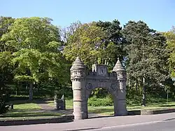 | |||
| Broughty Ferry, 96 Monifieth Road, Seabourne Lodge, Including Gatepiers | 56°28′12″N 2°51′17″W / 56.470071°N 2.854845°W | Category C(S) | 25862 | Upload Photo | |||
| Broughty Ferry, Queen Street, Public Library | 56°28′06″N 2°52′25″W / 56.468414°N 2.873522°W | Category C(S) | 25869 | Upload Photo | |||
| Broughty Ferry, 59-63 (Odd Nos) Reres Road, Airlie Lodge, Including Gatepiers And Boundary Walls | 56°28′21″N 2°51′18″W / 56.472424°N 2.855044°W | Category C(S) | 25875 | Upload Photo | |||
| Linlathen, East Bridge Over Dichty Water | 56°29′05″N 2°52′19″W / 56.484731°N 2.87203°W | Category A | 25892 | .jpg) | |||
| Stannergate, 306-308 Broughty Ferry Road, Including Boundary Wall | 56°28′08″N 2°55′29″W / 56.468825°N 2.924708°W | Category C(S) | 25899 | Upload Photo | |||
| West Ferry, 30 Albany Road, Balnacraig | 56°28′11″N 2°54′08″W / 56.469827°N 2.90209°W | Category B | 25904 | Upload Photo | |||
| West Ferry, Craigiebarn Road, Netherton Of Craigie Including Garden Wall | 56°28′18″N 2°54′56″W / 56.471552°N 2.915522°W | Category B | 25916 | Upload Photo | |||
| West Ferry, Craigiebarn Road, Craigiebarn, Including Garden Walls | 56°28′18″N 2°54′52″W / 56.471543°N 2.914386°W | Category B | 25917 | Upload Photo | |||
| West Ferry, 23 Douglas Terrace | 56°28′08″N 2°53′17″W / 56.468797°N 2.887944°W | Category B | 25920 | Upload Photo | |||
| Broughty Ferry, 150, 152 And 154 Brook Street, Masonic Hall | 56°28′02″N 2°52′36″W / 56.467341°N 2.876662°W | Category B | 25772 | Upload Photo | |||
| Broughty Ferry, Camperdown Street, Grove Academy, Including Boundary Walls And Railings | 56°28′12″N 2°52′49″W / 56.469911°N 2.88039°W | Category B | 25774 | Upload Photo | |||
| Broughty Ferry, 37 And 37A Camperdown Street, Cambus Lodge Including Gatepiers And Boundary Walls | 56°28′11″N 2°52′33″W / 56.4697°N 2.87597°W | Category C(S) | 25777 | Upload Photo | |||
| Broughty Ferry, 42 Camphill Road, Craig-Gowan, Including Walls And Gatepiers | 56°28′09″N 2°52′03″W / 56.469256°N 2.867487°W | Category B | 25782 | 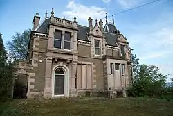 | |||
| Broughty Ferry, 44, 46 And 48 Camphill Road, Rowanbank, Including Wall, Gatepiers, Stable And Coach House | 56°28′10″N 2°52′00″W / 56.469324°N 2.866774°W | Category B | 25783 | Upload Photo | |||
| Broughty Ferry, 1-13 (Inclusive) Castle Terrace, Including Wall And Gatepiers, And Wall At Castle Street | 56°27′54″N 2°51′56″W / 56.464984°N 2.865491°W | Category C(S) | 25788 | Upload Photo | |||
| Broughty Ferry, Chapel Lane, Off Fisher Street, Old Burial Ground | 56°27′57″N 2°52′47″W / 56.465729°N 2.879644°W | Category B | 25789 | Upload Photo | |||
| Broughty Ferry, 8-18 Gray Street, Ferry House | 56°27′55″N 2°52′26″W / 56.465295°N 2.873759°W | Category B | 25825 | Upload Photo | |||
| Broughty Ferry, The Harbour | 56°27′50″N 2°52′19″W / 56.463852°N 2.871892°W | Category B | 25828 | 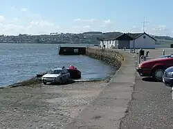 | |||
| Broughty Ferry, 6 Hermitage Road, The Hermitage Including Walls And Gatepiers | 56°28′06″N 2°52′12″W / 56.468421°N 2.869984°W | Category B | 25832 | Upload Photo | |||
| Broughty Ferry, 1A Hill Street | 56°28′11″N 2°52′28″W / 56.469818°N 2.874431°W | Category C(S) | 25834 | Upload Photo | |||
| Broughty Ferry, 21 Hill Street, Dunalistair Gardens, Vc House, Including Retaining Wall | 56°28′14″N 2°52′14″W / 56.470601°N 2.870488°W | Category B | 25837 | Upload Photo | |||
| Broughty Ferry, Hill Street, Lodge To Birchwood Roy (Formerly To Castleroy) | 56°28′14″N 2°52′11″W / 56.470497°N 2.869836°W | Category B | 25838 | Upload Photo | |||
| Broughty Ferry, 2 Hill Street, Including Boundary Wall, Gatepiers And Gateway | 56°28′11″N 2°52′29″W / 56.469671°N 2.874849°W | Category C(S) | 25839 | Upload Photo | |||
| Broughty Ferry, 8, 8A And 10 Hill Street, Herschel House | 56°28′09″N 2°52′22″W / 56.4693°N 2.872731°W | Category C(S) | 25841 | Upload Photo | |||
| 42-6 Wilkie's Lane, St Joseph's Roman Catholic Church And Presbytery, "Mount St Joseph" | 56°27′36″N 2°59′17″W / 56.459865°N 2.987924°W | Category B | 25686 | Upload Photo | |||
| Barnhill 11 Panmure Terrace, The Gorse, Including Former Coach House And Stable, Boundary Walls And Gatepiers | 56°28′24″N 2°51′09″W / 56.473439°N 2.852404°W | Category C(S) | 25746 | Upload Photo | |||
| Broughty Ferry, 19 Beach Crescent, Traquair | 56°27′55″N 2°52′24″W / 56.465181°N 2.873318°W | Category B | 25760 | Upload Photo | |||
| Broughty Ferry, 99 Beach Crescent And 1-5 (Odd Nos) St Vincent Street, The Red House | 56°27′52″N 2°52′17″W / 56.464485°N 2.871387°W | Category B | 25763 | Upload Photo | |||
| 21-29 (Odd Nos) Union Street | 56°27′32″N 2°58′16″W / 56.458982°N 2.971203°W | Category B | 25580 | Upload Photo | |||
| 31-47 Union Street, 25 Yeaman Shore | 56°27′32″N 2°58′15″W / 56.45885°N 2.970924°W | Category B | 25582 | Upload Photo | |||
| 10-16 (Even Nos) Perth Road | 56°27′24″N 2°58′44″W / 56.456604°N 2.978818°W | Category C(S) | 25583 | Upload Photo | |||
| 416, 418 Perth Road, Including Railings | 56°27′23″N 3°00′05″W / 56.456443°N 3.001254°W | Category C(S) | 25609 | Upload Photo | |||
| 428 Perth Road, Including Railings | 56°27′23″N 3°00′07″W / 56.456456°N 3.001871°W | Category C(S) | 25613 | Upload Photo | |||
| 1A West Bell Street, 18 Constitution Road, Regional Music Centre, Including Gatepiers And Railings, Formerly Bell Street UP Church | 56°27′45″N 2°58′30″W / 56.462447°N 2.975106°W | Category B | 25622 | Upload Photo | |||
| 474 Perth Road St Helens House, Lodge, Gatepiers And Boundary Walls | 56°27′20″N 3°00′46″W / 56.455684°N 3.012901°W | Category B | 25628 | Upload Photo | |||
| 484 Perth Road, Taypark With Boundary Walls | 56°27′21″N 3°00′54″W / 56.455783°N 3.015029°W | Category B | 25630 | Upload Photo | |||
| 10-22 (Even Nos) Whitehall Crescent | 56°27′33″N 2°58′10″W / 56.459185°N 2.969407°W | Category B | 25649 | Upload Photo | |||
| 3, 5, 7, Rockfield Street And 48, 50, 52 Shaftesbury Road Including Garden Walls And Gatepiers | 56°27′25″N 3°00′14″W / 56.456989°N 3.003816°W | Category B | 25650 | Upload Photo | |||
| 26-36 (Even Nos) Whitehall Street | 56°27′34″N 2°58′12″W / 56.459512°N 2.970032°W | Category B | 25669 | Upload Photo | |||
| 2-14 (Even Nos) Reform Street, 49, 50, 51 High Street | 56°27′39″N 2°58′14″W / 56.460747°N 2.970664°W | Category B | 25525 | Upload Photo | |||
| 38 And 40 Reform Street, 1 And 3 Bank Street | 56°27′41″N 2°58′18″W / 56.461504°N 2.971625°W | Category B | 25533 | Upload Photo | |||
| 60-64 (Even Nos) Reform Street, Meadow House | 56°27′43″N 2°58′20″W / 56.461904°N 2.972122°W | Category B | 25538 | Upload Photo | |||
| 239-257 (Odd Nos) Perth Road, Windsor Terrace, Including Boundary Walls And Gatepiers | 56°27′24″N 2°59′53″W / 56.456792°N 2.998083°W | Category C(S) | 25539 | Upload Photo | |||
| 33, 35 South Tay Street | 56°27′31″N 2°58′35″W / 56.458565°N 2.976288°W | Category B | 25550 | Upload Photo | |||
| 307-313 (Odd Nos) Perth Road, 1 Grosvenor Road, 62-6 (Even Nos) Shaftesbury Road, Grosvenor Terrace Boundary Walls And Gatepiers | 56°27′25″N 3°00′23″W / 56.45687°N 3.006312°W | Category B | 25557 | Upload Photo | |||
| 2, 4 South Tay Street, 115-121, (Odd Nos) Nethergate | 56°27′27″N 2°58′32″W / 56.457609°N 2.97555°W | Category B | 25560 | Upload Photo | |||
| 43-65 (Odd Nos) Trades Lane | 56°27′44″N 2°57′54″W / 56.462121°N 2.965036°W | Category B | 25574 | Upload Photo | |||
| 7 Guthrie Street, Railwaymen's Social Club, Former Ward Foundry Office | 56°27′40″N 2°58′49″W / 56.461247°N 2.9803°W | Category C(S) | 25427 | Upload Photo | |||
| 37, 39 Hyndford Street With Boundary Wall | 56°27′34″N 3°00′05″W / 56.459307°N 3.001508°W | Category C(S) | 25445 | Upload Photo | |||
| 2 Panmure Terrace, With Boundary Walls | 56°28′01″N 2°58′55″W / 56.467028°N 2.98204°W | Category B | 25446 | Upload Photo | |||
| Harrison Road, Timex Factory | 56°29′04″N 3°01′19″W / 56.484567°N 3.021984°W | Category B | 25448 | Upload Photo | |||
| 3 Panmure Terrace Druimbeg, With Boundary Walls | 56°28′01″N 2°58′57″W / 56.467052°N 2.982398°W | Category B | 25450 | Upload Photo | |||
| Pitalpin Street,335 South Road, Lochee, Pitalpin House | 56°28′29″N 3°01′31″W / 56.474764°N 3.025325°W | Category B | 25460 | Upload Photo | |||
| 2 Magdalen Place | 56°27′14″N 2°59′14″W / 56.453824°N 2.987248°W | Category C(S) | 25462 | Upload Photo | |||
| 105 Magdalen Yard Road, And 1A Osbourne Place, Osbourne Villa And Raewood Villa With Boundary Walls | 56°27′14″N 2°59′44″W / 56.453866°N 2.995524°W | Category B | 25496 | Upload Photo | |||
| 1-9 (Odd Nos) Milnbank Road And 2-12 (Even Nos) Polepark Road | 56°27′44″N 2°59′27″W / 56.46217°N 2.99071°W | Category C(S) | 25502 | Upload Photo | |||
| 2 Union Terrace, And Returns To Constitution Road And Constitution Terrace, Terrace House, With Boundary Walls And Gatepiers | 56°27′58″N 2°58′41″W / 56.466178°N 2.978123°W | Category B | 25506 | Upload Photo | |||
| Meadowside And Barrack Street, The Howff | 56°27′42″N 2°58′22″W / 56.461539°N 2.972794°W | Category A | 25312 |  | |||
| 57 Forfar Road | 56°28′47″N 2°57′07″W / 56.479589°N 2.951971°W | Category C(S) | 25315 | Upload Photo | |||
| Gardner Street, Lawside Convent Of Mercy, Or St Joseph's Convent, Including Chapel, And Boundary Walls | 56°28′04″N 2°59′46″W / 56.467859°N 2.996101°W | Category B | 25319 | Upload Photo | |||
| Harefield Road, Florence Booth House, Formerly Clement Park, Including Stable Wall And Garden Balustrade | 56°28′35″N 3°00′31″W / 56.476491°N 3.008682°W | Category B | 25330 | Upload Photo | |||
| 4 Meadowside, Head Post Office | 56°27′44″N 2°58′25″W / 56.462234°N 2.973591°W | Category B | 25336 | 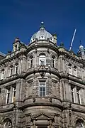 | |||
| 55 High Street Lochee, Tsb Former Dundee Savings Bank | 56°28′16″N 3°00′32″W / 56.471133°N 3.00901°W | Category B | 25349 | Upload Photo | |||
| 9, 11 Laurel Bank, Including Gatepiers And Boundary Walls | 56°27′55″N 2°58′32″W / 56.465336°N 2.975553°W | Category C(S) | 25389 | Upload Photo | |||
| 2, 4 Laurel Bank, With Boundary Walls, Railings And Gatepiers | 56°27′54″N 2°58′38″W / 56.465126°N 2.977187°W | Category B | 25393 | Upload Photo | |||
| 10 Laurel Bank, And Return To Prospect Place, With Boundary Walls, And Gatepiers | 56°27′56″N 2°58′35″W / 56.465473°N 2.9764°W | Category C(S) | 25401 | Upload Photo | |||
| 12 Laurel Bank, And Return To Prospect Place, With Boundary Walls And Gatepiers | 56°27′56″N 2°58′34″W / 56.465566°N 2.976046°W | Category B | 25405 | Upload Photo | |||
| 141, 143 Nethergate | 56°27′26″N 2°58′35″W / 56.457279°N 2.976385°W | Category B | 25406 | Upload Photo | |||
| 143C Nethergate | 56°27′27″N 2°58′36″W / 56.457458°N 2.976568°W | Category B | 25410 | Upload Photo | |||
| 1 High Street | 56°27′40″N 2°58′07″W / 56.461167°N 2.968695°W | Category C(S) | 25215 | Upload Photo | |||
| Crescent Street, Wallacetown Parish Church (Now Also Trinity Church, Church Of Scotland) | 56°28′03″N 2°57′36″W / 56.467577°N 2.960029°W | Category B | 25216 | Upload Photo | |||
| 1 Dudhope Terrace | 56°28′00″N 2°58′52″W / 56.466639°N 2.981202°W | Category B | 25226 | Upload Photo | |||
| 3 Dudhope Terrace | 56°28′00″N 2°58′55″W / 56.466578°N 2.982077°W | Category B | 25233 | Upload Photo | |||
| 70-73 (Inclusive Nos) High Street, Including Gardyne's Land, Gray's Close And Clock With Model Of The Town House | 56°27′40″N 2°58′11″W / 56.460979°N 2.96981°W | Category A | 25239 | .jpg) | |||
| 1-10 (Inclusive Nos) City Square And 5-8 (Inclusive Nos) High Street, East Wing Of City Square | 56°27′38″N 2°58′09″W / 56.460615°N 2.969249°W | Category C(S) | 25255 | Upload Photo | |||
| 234-238 (Even Nos) Hilltown, 4, 6 Stirling Street | 56°28′09″N 2°58′30″W / 56.469141°N 2.975017°W | Category B | 25260 | Upload Photo | |||
| 14-22 (Inclusive Nos) City Square, 22-24 (Inclusive Nos) High Street And 2-18 (Even Nos) Crichton Street, West Wing Of City Square | 56°27′37″N 2°58′12″W / 56.460159°N 2.970114°W | Category B | 25262 |  | |||
| 5-19 (Odd Nos) King Street And 28, 30, 32 Cowgate | 56°27′52″N 2°58′01″W / 56.464578°N 2.966818°W | Category B | 25271 | Upload Photo | |||
| 1-31 (Odd Nos) Lyon Street, And 30 Albert Street | 56°28′07″N 2°57′33″W / 56.468708°N 2.959067°W | Category B | 25287 | Upload Photo | |||
| 1 And 3 Perth Road, Ellenbank And Union Mount, University Of Dundee, Including Gatepiers And Boundary Wall | 56°27′26″N 2°58′48″W / 56.457126°N 2.979902°W | Category B | 25289 |  | |||
| 60 Small's Wynd, Old Technical Institute, Including Former College Hall, Boundary Wall And Gatepiers | 56°27′27″N 2°58′44″W / 56.457412°N 2.979001°W | Category B | 25308 | Upload Photo | |||
| Taylor's Lane, Seafield Works (West Side Of Taylor's Lane Only) | 56°27′19″N 2°59′39″W / 56.455207°N 2.994082°W | Category A | 25111 | Upload Photo | |||
| 11-19 (Odd Nos) Cowgate, Caxton House | 56°27′49″N 2°58′05″W / 56.463553°N 2.968009°W | Category C(S) | 25120 | Upload Photo | |||
| 11, 13 Crichton Street | 56°27′35″N 2°58′13″W / 56.459835°N 2.970154°W | Category B | 25128 | Upload Photo | |||
| 2 Wallace Street, Blackscroft And Constable Street, Wallace Craigie Works Offices | 56°27′58″N 2°57′29″W / 56.466128°N 2.958126°W | Category B | 25136 | Upload Photo | |||
| 2 Clive Street With Boundary Walls | 56°28′37″N 2°57′23″W / 56.477067°N 2.956323°W | Category B | 25149 | Upload Photo | |||
| 16-19 (Inclusive Nos) Dock Street/3-9 (Odd Nos) Exchange Street/15 Shore Terrace, Former Exchange Coffee House | 56°27′37″N 2°58′03″W / 56.460153°N 2.967371°W | Category A | 25150 | .jpg) | |||
| 56 West Henderson's Wynd, Former Meadow Or North Dudhope Mill | 56°27′44″N 2°59′04″W / 56.462229°N 2.984399°W | Category B | 25152 | Upload Photo | |||
| 2, 4 Constitution Terrace And 82, Constitution Street Including Boundary Walls And Gatepiers | 56°28′00″N 2°58′43″W / 56.466543°N 2.978603°W | Category B | 25161 | Upload Photo | |||
| 3 Coupar Angus Road Lochee West Church Manse | 56°28′29″N 3°00′45″W / 56.474708°N 3.01245°W | Category C(S) | 25176 | Upload Photo | |||
| Blacks Croft And Foundry Lane, "Ricks", Former St Roques Public Library, Including Railings, Balusters And Garden Walls | 56°27′54″N 2°57′42″W / 56.464942°N 2.961634°W | Category B | 25191 | Upload Photo | |||
| 2 Euclid Street, High School Preparatory Department | 56°27′45″N 2°58′28″W / 56.462371°N 2.974406°W | Category B | 25193 | Upload Photo | |||
| 2, 4 Candle Lane And 99 Seagate And 25-37 (Odd Nos) Trades Lane, Watson's Bond, Hm Customs Warehouse No 4 (Excluding 1 And 2-Storey Building) | 56°27′45″N 2°58′01″W / 56.462438°N 2.966959°W | Category A | 25194 | Upload Photo | |||
| 26 Castle Street, Castle Chambers | 56°27′38″N 2°58′05″W / 56.46065°N 2.96813°W | Category B | 25028 | Upload Photo | |||
| West Marketgait, 2 Guthrie Street And 30 East Henderson's Wynd, Former Tay Works Calender | 56°27′40″N 2°58′43″W / 56.461018°N 2.978558°W | Category B | 25037 | Upload Photo | |||
| 42-48 (Even Nos) Castle Street/2-8 (Even Nos) Exchange Street | 56°27′38″N 2°58′03″W / 56.460475°N 2.967542°W | Category B | 25039 | Upload Photo | |||
| Castle Street And Shore Terrace, North West Corner, Lampstandard | 56°27′37″N 2°58′04″W / 56.460168°N 2.967728°W | Category C(S) | 25043 | Upload Photo | |||
| 82-86 (Even Nos) Broughty Ferry Road | 56°28′00″N 2°57′09″W / 56.466648°N 2.952442°W | Category B | 25045 | Upload Photo | |||
| 19, 21 Commercial Street | 56°27′40″N 2°58′00″W / 56.461183°N 2.966683°W | Category C(S) | 25055 | Upload Photo | |||
| Caird Park, Mains Farm, Former Granary And Horse Mill Only | 56°29′03″N 2°57′34″W / 56.484266°N 2.959427°W | Category C(S) | 25074 | Upload Photo | |||
| 34 Commercial Street Former Flour Mill | 56°27′39″N 2°58′03″W / 56.460881°N 2.967373°W | Category B | 25091 | Upload Photo | |||
| Clatto Reservoir, With Sluice House, Entrance Railings And Gatepiers | 56°29′57″N 3°01′39″W / 56.499067°N 3.027475°W | Category B | 25106 | Upload Photo | |||
| Clatto Reservoir, Waterworks Cottage | 56°29′53″N 3°01′27″W / 56.497953°N 3.024293°W | Category B | 25109 | Upload Photo | |||
| 64, 66 Barrack Street And Return Elevation To South Ward Road, Friarfield House | 56°27′41″N 2°58′26″W / 56.461332°N 2.973973°W | Category B | 24941 | Upload Photo | |||
| Marine Parade, Harbour Workshops And Patent Slip | 56°27′36″N 2°57′38″W / 56.459883°N 2.960516°W | Category A | 24957 | Upload Photo | |||
| Telford Light, Dundee Waterfront Near Tay Bridge | 56°27′32″N 2°57′55″W / 56.458984°N 2.965183°W | Category B | 24966 | Upload Photo | |||
| 7, 9, 11 Bell Street, Baltic Chambers | 56°27′48″N 2°58′20″W / 56.463413°N 2.972112°W | Category C(S) | 24973 | Upload Photo | |||
| Barrack Rd Dundee Royal Infirmary, Original Block Out Patients Dept & Urology Theatre | 56°27′55″N 2°58′51″W / 56.465214°N 2.98076°W | Category A | 24982 | Upload Photo | |||
| Constable Street And Return Elevation To Dens Street (E Side) | 56°27′56″N 2°57′43″W / 56.465559°N 2.961909°W | Category B | 24985 | Upload Photo | |||
| 17, 18 Baxter Park Terrace, 35 Park Avenue | 56°28′17″N 2°57′11″W / 56.471332°N 2.953127°W | Category B | 25004 | Upload Photo | |||
| 8 Bingham Terrace The Anchorage | 56°28′24″N 2°56′45″W / 56.473266°N 2.945822°W | Category B | 25012 | Upload Photo | |||
| 36, 38 Bingham Terrace | 56°28′26″N 2°56′31″W / 56.473807°N 2.941972°W | Category C(S) | 25023 | Upload Photo | |||
| 1 Albany Terrace, With Boundary Walls And Gatepiers | 56°28′03″N 2°58′56″W / 56.46754°N 2.982086°W | Category B | 24924 | Upload Photo | |||
| Albert Square, Statue Of Robert Burns | 56°27′44″N 2°58′19″W / 56.462354°N 2.971971°W | Category B | 24925 | Upload Photo | |||
| 28 Annfield Road, Baltic Works, Chimney And Former Mill | 56°27′29″N 2°59′31″W / 56.457973°N 2.992061°W | Category B | 24927 | 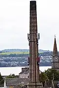 | |||
| West Ferry, 22 Douglas Terrace | 56°28′08″N 2°53′15″W / 56.4688°N 2.887571°W | Category C(S) | 25922 | Upload Photo | |||
| West Ferry, 4 Duntrune Terrace, Melford Including Enclosing Wall And Gatepiers | 56°28′24″N 2°53′18″W / 56.473349°N 2.888375°W | Category C(S) | 25933 | Upload Photo | |||
| West Ferry, 92 And 94 Grove Road | 56°28′27″N 2°53′26″W / 56.474187°N 2.890586°W | Category C(S) | 25945 | Upload Photo | |||
| Broughty Ferry, 357 King Street, Links House, With Gatepiers And Boundary Walls At S, E And W | 56°27′55″N 2°52′13″W / 56.465239°N 2.870187°W | Category B | 25846 | Upload Photo | |||
| Broughty Ferry, 37 Monifieth Road, Kazarami, Including Boundary Wall | 56°28′05″N 2°52′00″W / 56.468094°N 2.8666°W | Category B | 25851 | Upload Photo | |||
| Broughty Ferry, 47 And 49 Monifieth Road, Including Wall And Gatepiers | 56°28′06″N 2°51′56″W / 56.4683°N 2.865453°W | Category C(S) | 25852 | Upload Photo | |||
| Broughty Ferry, 51 And 53 Monifieth Road, Including Garage, Walls And Gatepiers | 56°28′06″N 2°51′54″W / 56.468356°N 2.865129°W | Category C(S) | 25853 | Upload Photo | |||
| Broughty Ferry, 71 Monifieth Road, Reres Lodge, Including Gatepiers And Boundary Wall | 56°28′07″N 2°51′46″W / 56.468741°N 2.862801°W | Category C(S) | 25855 | Upload Photo | |||
| Broughty Ferry, Queen Street, Guliston House, Former Queen Street Church, Including Wall And Railings | 56°28′06″N 2°52′28″W / 56.468371°N 2.874511°W | Category B | 25873 | Upload Photo | |||
| Broughty Ferry, 41 Reres Road, Former Stable Court To Rocknowe House | 56°28′17″N 2°51′35″W / 56.471259°N 2.859806°W | Category C(S) | 25874 | Upload Photo | |||
| Broughty Ferry, 30 Seafield Road, The Pines, Including Gatepiers, Boundary Wall And Lampstandard | 56°27′31″N 2°58′15″W / 56.458698°N 2.970823°W | Category C(S) | 25882 | Upload Photo | |||
| Broughty Ferry, 2 Whinnybrae, Eastern Primary School, Including Wall And Entrance Gates, And Playsheds And Lavatories At Rear | 56°28′05″N 2°52′06″W / 56.468046°N 2.86832°W | Category A | 25887 |  | |||
| Lammerton, Road Bridge Over Murroes Burn | 56°29′25″N 2°53′12″W / 56.490342°N 2.886677°W | Category B | 25890 | Upload Photo | |||
| Linlathen, West Bridge Over Dichty Water | 56°29′00″N 2°52′40″W / 56.483316°N 2.877761°W | Category A | 25893 | Upload Photo | |||
| Stannergate, 310 Broughty Ferry Road, Ingleside, Including Gatepiers And Boundary Walls | 56°28′08″N 2°55′27″W / 56.468919°N 2.924143°W | Category B | 25900 | Upload Photo | |||
| West Ferry, 3 Albert Road, Broomfield Nurseries, Including Conservatory, Formerly Broomhall | 56°28′16″N 2°53′07″W / 56.471242°N 2.885242°W | Category B | 25907 | Upload Photo | |||
| West Ferry, 4 And 6 Bayfield Road And 16 Albert Road, Lynfield, Including Gatepiers And Wall | 56°28′12″N 2°53′04″W / 56.470026°N 2.884434°W | Category B | 25910 | Upload Photo | |||
| West Ferry, Beach Lane, Railway Footbridge | 56°28′07″N 2°53′31″W / 56.468724°N 2.89187°W | Category B | 25911 | Upload Photo | |||
| West Ferry, Claypotts Road, Claypotts Castle | 56°28′35″N 2°53′24″W / 56.476527°N 2.889943°W | Category A | 25913 |  | |||
| Broughty Ferry, 1, 3 And 5 Camphill Road, Enclosing Wall And Gatepiers Only | 56°28′07″N 2°52′29″W / 56.468486°N 2.874838°W | Category C(S) | 25778 | Upload Photo | |||
| Broughty Ferry, 115 Fisher Street, Barometer Cottage | 56°27′54″N 2°52′37″W / 56.46512°N 2.876871°W | Category B | 25800 |  | |||
| Broughty Ferry, Fisher Street, Lifeboat House, Including Slipway | 56°27′54″N 2°52′38″W / 56.46501°N 2.877225°W | Category B | 25805 |  | |||
| Broughty Ferry, 20 Gray Street | 56°27′55″N 2°52′25″W / 56.465385°N 2.873728°W | Category B | 25826 | Upload Photo | |||
| Broughty Ferry, 22 Gray Street | 56°27′56″N 2°52′25″W / 56.465457°N 2.873681°W | Category B | 25827 | Upload Photo | |||
| 1-6 (Inclusive Nos) Windsor Place | 56°27′15″N 2°59′49″W / 56.454142°N 2.996894°W | Category B | 25687 | Upload Photo | |||
| Baldovie, Baldovie Toll House | 56°29′20″N 2°53′33″W / 56.488854°N 2.892391°W | Category B | 25735 | Upload Photo | |||
| Balmossie, Panmure Bleachfield, Cottages And Stable Block | 56°28′56″N 2°50′40″W / 56.4821°N 2.844529°W | Category B | 25740 | Upload Photo | |||
| Balmossie, Panmure Bleachfield, House/Tenement | 56°28′58″N 2°50′54″W / 56.48273°N 2.848326°W | Category B | 25741 | Upload Photo | |||
| Barnhill, Invermark Terrace, Barnhill St Margaret's Church | 56°28′25″N 2°50′52″W / 56.473632°N 2.84788°W | Category B | 25743 | Upload Photo | |||
| Barnhill, 6 And 8 Panmure Terrace, Ferncroft, Including Garage, Gatepiers And Gates | 56°28′23″N 2°51′08″W / 56.473054°N 2.852298°W | Category B | 25749 | Upload Photo | |||
| Barnhill, 27 Strathmore Street, Barnhill Cemetery Lodge | 56°28′29″N 2°51′25″W / 56.474685°N 2.856832°W | Category C(S) | 25750 | Upload Photo |
Key
The scheme for classifying buildings in Scotland is:
- Category A: "buildings of national or international importance, either architectural or historic; or fine, little-altered examples of some particular period, style or building type."[1]
- Category B: "buildings of regional or more than local importance; or major examples of some particular period, style or building type, which may have been altered."[1]
- Category C: "buildings of local importance; lesser examples of any period, style, or building type, as originally constructed or moderately altered; and simple traditional buildings which group well with other listed buildings."[1]
In March 2016 there were 47,288 listed buildings in Scotland. Of these, 8% were Category A, and 50% were Category B, with the remaining 42% being Category C.[2]
See also
Notes
- ^ Sometimes known as OSGB36, the grid reference (where provided) is based on the British national grid reference system used by the Ordnance Survey.
• "Guide to National Grid". Ordnance Survey. Retrieved 12 December 2007.
• "Get-a-map". Ordnance Survey. Retrieved 17 December 2007. - ^ Historic Environment Scotland assign a unique alphanumeric identifier to each designated site in Scotland, for listed buildings this always begins with "LB", for example "LB12345".
References
- All entries, addresses and coordinates are based on data from Historic Scotland. This data falls under the Open Government Licence
- ^ a b c "What is Listing?". Historic Environment Scotland. Retrieved 29 May 2018.
- ^ Scotland's Historic Environment Audit 2016 (PDF). Historic Environment Scotland and the Built Environment Forum Scotland. pp. 15–16. Retrieved 29 May 2018.