List of listed buildings in Dundee/5
This is a list of listed buildings in Dundee, Scotland.
List
| Name | Location | Date Listed | Grid Ref. [note 1] | Geo-coordinates | Notes | LB Number [note 2] | Image |
|---|---|---|---|---|---|---|---|
| Broughty Ferry, 218 Queen Street, Post Office | 56°28′05″N 2°52′33″W / 56.468191°N 2.875887°W | Category C(S) | 25871 |  Upload Photo | |||
| Broughty Ferry, Queen Street, East Church | 56°28′03″N 2°52′14″W / 56.467482°N 2.870693°W | Category B | 25872 | Upload Photo | |||
| Broughty Ferry, 158 St Vincent Street | 56°28′00″N 2°52′11″W / 56.466645°N 2.869586°W | Category C(S) | 25877 | Upload Photo | |||
| Broughty Ferry, St Vincent Street, Baptist Church | 56°27′56″N 2°52′12″W / 56.465474°N 2.869981°W | Category C(S) | 25879 | Upload Photo | |||
| West Ferry, Craigiebarn Road, Stirling House, Including Wall In Garden | 56°28′16″N 2°54′58″W / 56.471009°N 2.916077°W | Category B | 25918 | Upload Photo | |||
| Broughty Ferry, 151 Brook Street, Ymca Gymnasium | 56°28′04″N 2°52′38″W / 56.467768°N 2.877224°W | Category C(S) | 25767 | Upload Photo | |||
| Broughty Ferry, 134 Brook Street, Former Municipal Buildings, Including Wrought-Iron Arch And Clock | 56°28′03″N 2°52′39″W / 56.467425°N 2.877395°W | Category C(S) | 25771 | Upload Photo | |||
| Broughty Ferry, 79-85 (Odd Nos) Fisher Street | 56°27′55″N 2°52′41″W / 56.465283°N 2.877994°W | Category C(S) | 25796 | Upload Photo | |||
| Broughty Ferry, 87 Fisher Street | 56°27′55″N 2°52′40″W / 56.465239°N 2.877782°W | Category C(S) | 25797 | Upload Photo | |||
| Broughty Ferry, 89 Fisher Street | 56°27′55″N 2°52′40″W / 56.465258°N 2.877669°W | Category C(S) | 25798 | Upload Photo | |||
| Broughty Ferry, 161 Fisher Street | 56°27′54″N 2°52′32″W / 56.465003°N 2.875635°W | Category C(S) | 25801 | Upload Photo | |||
| Broughty Ferry, 16 Fort Street | 56°27′56″N 2°52′37″W / 56.46548°N 2.876863°W | Category C(S) | 25813 | Upload Photo | |||
| Broughty Ferry, 48 Fort Street | 56°27′58″N 2°52′35″W / 56.466237°N 2.876491°W | Category C(S) | 25815 | Upload Photo | |||
| Broughty Ferry, 21 Hill Street, Dunalistair Gardens, Dunalistair, Including Detached Former Service Wing,_Retaining Wall And Balustrade | 56°28′14″N 2°52′16″W / 56.470632°N 2.871089°W | Category B | 25836 | Upload Photo | |||
| 49 Seafield Road And 6 Magdalen Place, Elm Lodge With Boundary Walls | 56°27′16″N 2°59′14″W / 56.454408°N 2.987247°W | Category B | 25677 | Upload Photo | |||
| Tullideph Road, St Francis Friary (Rc) | 56°27′57″N 2°59′55″W / 56.465915°N 2.998744°W | Category B | 25682 | Upload Photo | |||
| 53-61 (Odd Nos) West Port And 3, 5, Johnston's Lane | 56°27′34″N 2°58′47″W / 56.459571°N 2.979738°W | Category B | 25685 | Upload Photo | |||
| Baldovie, Baldovie House, Including Boundary Wall | 56°29′16″N 2°53′42″W / 56.487748°N 2.894996°W | Category C(S) | 25734 | Upload Photo | |||
| Barnhill 5 Montagu Street (Formerly The Shieling) | 56°28′32″N 2°50′54″W / 56.475659°N 2.848363°W | Category C(S) | 25745 | Upload Photo | |||
| By 40 Perth Road, Seabraes Gentlemen's Lavatories | 56°27′24″N 2°58′47″W / 56.456543°N 2.97979°W | Category B | 25589 | Upload Photo | |||
| 158 Perth Road, St Mark's Church (Gate Fellowship) | 56°27′22″N 2°59′08″W / 56.456103°N 2.985425°W | Category A | 25601 | 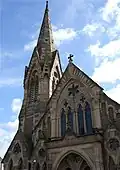 | |||
| 412 Perth Road, The Binns | 56°27′22″N 3°00′04″W / 56.456086°N 3.00105°W | Category B | 25605 | Upload Photo | |||
| 4 Ward Road, Auction Rooms | 56°27′41″N 2°58′28″W / 56.461517°N 2.974497°W | Category C(S) | 25612 | Upload Photo | |||
| 452 Perth Road, Greywalls | 56°27′20″N 3°00′19″W / 56.455504°N 3.005205°W | Category A | 25617 | Upload Photo | |||
| 506 Perth Road West Dene, With Boundary Walls And Gatepiers | 56°27′23″N 3°01′11″W / 56.456302°N 3.019683°W | Category B | 25634 | Upload Photo | |||
| 24 Whitehall Crescent, 9, 10 Dock Street, Gilfillan Memorial Church | 56°27′33″N 2°58′11″W / 56.459111°N 2.969633°W | Category B | 25651 | Upload Photo | |||
| 17, 17A Roseangle And 10 Greenfield Place With Boundary Walls | 56°27′20″N 2°59′01″W / 56.455435°N 2.983574°W | Category B | 25654 | Upload Photo | |||
| 9-13 Whitehall Street, Whitehall Chambers | 56°27′33″N 2°58′13″W / 56.459267°N 2.970367°W | Category B | 25661 | Upload Photo | |||
| 225 Perth Road And Blackness Avenue, Blackness Branch Library, With Railings | 56°27′25″N 2°59′46″W / 56.456817°N 2.996185°W | Category B | 25532 | Upload Photo | |||
| 231-233 Perth Road, Blackness Crescent With Boundary Walls | 56°27′25″N 2°59′50″W / 56.456853°N 2.997225°W | Category C(S) | 25536 | Upload Photo | |||
| Riverside Drive, Discovery Quay, Alexandra Fountain | 56°27′22″N 2°58′09″W / 56.456186°N 2.96912°W | Category B | 25541 | Upload Photo | |||
| 315 Perth Road, Western Cemetery Entrance Screen, Boundary Walls, Monuments And Lodges, 2 And 4 Grosvenor Road | 56°27′24″N 3°00′28″W / 56.45674°N 3.00785°W | Category B | 25559 | Upload Photo | |||
| 325 Perth Road University, Formerly Elmslea, House And Lodge, Boundary Walls And Gatepiers | 56°27′24″N 3°00′40″W / 56.456669°N 3.01111°W | Category B | 25563 | Upload Photo | |||
| 333 Perth Road Including Boundary Walls And E Gatepiers, Formerly To Farington Hall | 56°27′25″N 3°00′54″W / 56.456809°N 3.01491°W | Category C(S) | 25569 | Upload Photo | |||
| 86 Nethergate, St David's Halls, (In Close To Rear Of 84, 88 And 90 Nethergate) | 56°27′31″N 2°58′19″W / 56.458652°N 2.972023°W | Category B | 25429 | Upload Photo | |||
| Hazel Avenue Or 385 Perth Road, Wayside | 56°27′32″N 3°01′45″W / 56.459019°N 3.029054°W | Category C(S) | 25439 | Upload Photo | |||
| 1 Panmure Terrace, With Boundary Walls And Gatepiers | 56°28′01″N 2°58′54″W / 56.467067°N 2.981651°W | Category B | 25443 | Upload Photo | |||
| 6 Paradise Road, Marrbank, And 7, 9 Dudhope Street, With Boundary Walls And Gatepiers | 56°27′53″N 2°58′31″W / 56.464602°N 2.975242°W | Category B | 25457 | Upload Photo | |||
| 172 Nethergate, Spring Grove, (Formerly Caird Rest), Including Balustraded Steps And Boundary Walls | 56°27′24″N 2°58′40″W / 56.456657°N 2.977894°W | Category B | 25477 | Upload Photo | |||
| 59 Magdalen Yard Road, Royal Dundee Institution For The Blind, (Building Fronting Magdalen Yard Road Only) With Boundary Walls And Gatepiers | 56°27′12″N 2°59′27″W / 56.453408°N 2.990969°W | Category C(S) | 25478 | Upload Photo | |||
| 43, 45 North Lindsay Street | 56°27′40″N 2°58′33″W / 56.461093°N 2.975915°W | Category B | 25483 | Upload Photo | |||
| 26-36 (Even Nos) North Lindsay Street | 56°27′36″N 2°58′29″W / 56.459952°N 2.974766°W | Category B | 25486 | Upload Photo | |||
| Magdalen Yard Road, 91, 93, Seafield Lodge | 56°27′14″N 2°59′39″W / 56.45393°N 2.99426°W | Category B | 25493 | Upload Photo | |||
| 10 Milnbank Road With Railings | 56°27′43″N 2°59′26″W / 56.461965°N 2.990591°W | Category B | 25505 | Upload Photo | |||
| 48, 50 St Andrews Street Or Lane, And Cowgate, Former Dundee Calender And Villa: "The Sea Captain's House" | 56°27′50″N 2°57′59″W / 56.463826°N 2.96641°W | Category B | 25310 | Upload Photo | |||
| 81 Seagate And Return Elevation To Candle Lane Former No 2 Customs Warehouse | 56°27′44″N 2°58′00″W / 56.462287°N 2.966744°W | Category B | 25318 | Upload Photo | |||
| 9 Wellington Street, Walker House | 56°28′03″N 2°57′57″W / 56.467496°N 2.96587°W | Category C(S) | 25337 | Upload Photo | |||
| 22 Meadowside, 2 Courier Place, Euclid Crescent, Courier Building | 56°27′44″N 2°58′22″W / 56.462177°N 2.97281°W | Category B | 25339 | 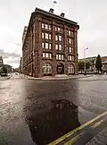 | |||
| 191 High Street, Lochee, Lochee West Church (Church Of Scotland) | 56°28′28″N 3°00′45″W / 56.474519°N 3.012477°W | Category B | 25357 | Upload Photo | |||
| Balgay Park Pavilion | 56°27′50″N 3°00′49″W / 56.463862°N 3.013703°W | Category B | 25360 | Upload Photo | |||
| 191 High Street, And Nicholl's Lane, Lochee, Lochee West Church Hall | 56°28′27″N 3°00′43″W / 56.474046°N 3.012059°W | Category C(S) | 25361 | Upload Photo | |||
| High Street, Lochee And Old Muirton Road Former Lochee Station, Now Lochee Burns Club | 56°28′11″N 3°00′22″W / 56.469817°N 3.006184°W | Category B | 25365 | 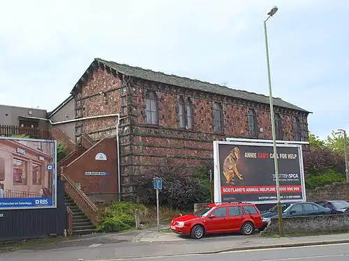 | |||
| Nethergate, City Churches, St Mary's Tower, Or The Steeple | 56°27′34″N 2°58′23″W / 56.459416°N 2.973129°W | Category A | 25370 | Upload Photo | |||
| Nethergate, Mercat Cross | 56°27′32″N 2°58′23″W / 56.45895°N 2.972988°W | Category B | 25386 | Upload Photo | |||
| 432 Blackness Road, Redcroft With Boundary Walls And Gatepiers (Excluding Lodges) | 56°27′32″N 3°01′10″W / 56.458981°N 3.01956°W | Category B | 25392 | Upload Photo | |||
| Law Hill War Memorial | 56°28′11″N 2°59′22″W / 56.469746°N 2.989349°W | Category B | 25409 | 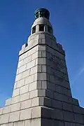 | |||
| 24 Exchange Street | 56°27′39″N 2°58′01″W / 56.460865°N 2.967081°W | Category B | 25211 | Upload Photo | |||
| Dens Road Primary School Including Air Intake For Plenum Heating, System, Janitors House And Railings | 56°28′23″N 2°58′13″W / 56.472925°N 2.97018°W | Category B | 25225 | Upload Photo | |||
| 26, 28 High Street | 56°27′36″N 2°58′14″W / 56.459977°N 2.970417°W | Category B | 25227 | Upload Photo | |||
| 2 Dudhope Terrace | 56°28′00″N 2°58′54″W / 56.466618°N 2.981624°W | Category B | 25229 | Upload Photo | |||
| 10 Dudhope Terrace | 56°27′58″N 2°59′06″W / 56.466178°N 2.985004°W | Category B | 25257 | Upload Photo | |||
| 240 Hilltown And 1A Stirling Street. Former Dundee Savings Bank | 56°28′10″N 2°58′31″W / 56.46939°N 2.975316°W | Category B | 25264 | Upload Photo | |||
| Off Perth Road, Geddes Quadrangle, East Wing, (Also Known As East Wing Of Harris Building), University Of Dundee | 56°27′27″N 2°58′48″W / 56.457637°N 2.980077°W | Category B | 25277 | Upload Photo | |||
| 22 Powrie Place And Forebank Road, St Mary's Rc Presbytery | 56°28′01″N 2°58′15″W / 56.466963°N 2.970855°W | Category B | 25298 | Upload Photo | |||
| Thistle Street, Bowbridge Works, Gates And Gatepiers | 56°28′19″N 2°58′28″W / 56.471831°N 2.974535°W | Category C(S) | 25118 | Upload Photo | |||
| Victoria Street, Former Eagle Jute Mills (Victoria Street Front Only) | 56°28′04″N 2°57′44″W / 56.467803°N 2.962242°W | Category B | 25129 | Upload Photo | |||
| 21 Crichton Street | 56°27′35″N 2°58′12″W / 56.459738°N 2.969876°W | Category C(S) | 25134 | Upload Photo | |||
| 27 West Henderson's Wynd And Return Elevation To Milne Street, Verdant Works | 56°27′42″N 2°58′58″W / 56.461567°N 2.982905°W | Category A | 25140 | .jpg) | |||
| 2 West Henderson's Wynd, Former South Anchor Mill Weaving Factory | 56°27′40″N 2°59′04″W / 56.461214°N 2.984486°W | Category C(S) | 25144 | Upload Photo | |||
| 45 Constitution Street And 1 Upper Constitution Street, Dungarth Gatepiers, Gates And Overthrow Arch | 56°28′01″N 2°58′45″W / 56.467077°N 2.979282°W | Category B | 25153 | Upload Photo | |||
| 62, 63 Dock Street, 15 And 17 Candle Lane, Unicorn House, Former Sailors' Home And Chapel | 56°27′42″N 2°57′53″W / 56.461693°N 2.964619°W | Category B | 25173 | Upload Photo | |||
| 4 Euclid Crescent, Trinity Hall, High School of Dundee, Formerly Original Secession Church | 56°27′48″N 2°58′20″W / 56.463278°N 2.972141°W | Category C(S) | 25185 | Upload Photo | |||
| Dudhope Castle | 56°27′51″N 2°59′03″W / 56.464262°N 2.984111°W | Category A | 25195 | .jpg) | |||
| 37, 39, 41 Cowgate | 56°27′51″N 2°58′01″W / 56.464055°N 2.966983°W | Category B | 25205 | Upload Photo | |||
| Broughty Ferry Road, Roodyards Burial Ground With Guthrie Mausoleum | 56°28′01″N 2°56′45″W / 56.466977°N 2.945779°W | Category B | 25038 | Upload Photo | |||
| Methven Street, Camperdown Works, Cox's Stack | 56°28′22″N 3°00′12″W / 56.472787°N 3.003438°W | Category A | 25044 |  | |||
| 2, 4 Commercial Street/37-40 (Inclusive Nos) Dock Street, Brough's Buildings | 56°27′39″N 2°57′59″W / 56.460718°N 2.966314°W | Category B | 25079 | Upload Photo | |||
| Camperdown Country Park, Stables And Former Tacksman's House | 56°29′07″N 3°02′50″W / 56.485309°N 3.047158°W | Category B | 25086 | Upload Photo | |||
| 36-42 Commercial Street, St Roque's Hall, Including Boundary Wall, Archway And Steps To High Street | 56°27′41″N 2°58′05″W / 56.461252°N 2.968129°W | Category B | 25095 | Upload Photo | |||
| 8 Constitution Road, Ward Congregational Church | 56°27′43″N 2°58′30″W / 56.461998°N 2.97498°W | Category B | 25107 | Upload Photo | |||
| Albert Square, Mcmanus Galleries, Formerly Albert Institute, Including Lampstandards | 56°27′45″N 2°58′15″W / 56.462615°N 2.970761°W | Category A | 24939 | 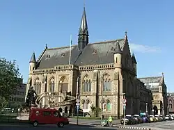 | |||
| Eastern Wharf, Princess Alexandra Wharf And Caledon West Wharf | 56°27′50″N 2°56′37″W / 56.463967°N 2.943481°W | Category B | 24947 | Upload Photo | |||
| 7-25 (Odd Nos) Bank Street | 56°27′41″N 2°58′19″W / 56.461258°N 2.972024°W | Category B | 24954 | Upload Photo | |||
| Balmuir Bridge | 56°29′43″N 2°58′34″W / 56.495277°N 2.976045°W | Category B | 24977 | Upload Photo | |||
| 31, 33 Castle Street | 56°27′37″N 2°58′06″W / 56.460398°N 2.968237°W | Category B | 25013 | Upload Photo | |||
| 10 Castle Street | 56°27′39″N 2°58′07″W / 56.460898°N 2.968591°W | Category C(S) | 25017 | Upload Photo | |||
| 32, 34 Bingham Terrace | 56°28′25″N 2°56′32″W / 56.473732°N 2.94236°W | Category C(S) | 25019 | Upload Photo | |||
| 63-73 (Odd Nos) King Street | 56°27′55″N 2°57′52″W / 56.465379°N 2.964323°W | Category B | 25022 | Upload Photo | |||
| Albert Square, Statue Of James Carmichael | 56°27′47″N 2°58′15″W / 56.462921°N 2.970703°W | Category B | 24930 | .jpg) | |||
| West Ferry, 32 Dundee Road, Magdala, Including Wall And Gatepiers | 56°28′10″N 2°53′32″W / 56.469323°N 2.892193°W | Category B | 25928 | Upload Photo | |||
| West Ferry, 34 Dundee Road, Including Walls And Gatepiers, Fort William, Royal Tay Yacht Club | 56°28′09″N 2°53′27″W / 56.469297°N 2.890926°W | Category B | 25929 | Upload Photo | |||
| West Ferry, 17 Fairfield Road, Red Court Coach House And Stable | 56°28′19″N 2°54′10″W / 56.471862°N 2.902706°W | Category B | 25940 | Upload Photo | |||
| West Ferry, 6 Ralston Road, 1-6 (Inclusive Nos) Beachtower, Including Gatepiers And Boundary Walls | 56°28′10″N 2°54′23″W / 56.469392°N 2.906316°W | Category A | 25947 | Upload Photo | |||
| West Ferry, 118 Strathern Road, Northwood Lodge | 56°28′22″N 2°53′18″W / 56.472738°N 2.888409°W | Category C(S) | 25949 | Upload Photo | |||
| West Ferry, West Ferry Bay, Royal Tay Yacht Club, Beachclubhouse | 56°28′07″N 2°53′38″W / 56.468484°N 2.893991°W | Category B | 25954 | Upload Photo | |||
| Hawkhill, Blackness (Formerly Hawkhill) Primary School | 56°27′24″N 2°59′30″W / 56.456745°N 2.991689°W | Category B | 25956 | Upload Photo | |||
| Broughty Ferry, West Queen Street, St Luke's And Queen Street Church | 56°28′10″N 2°53′00″W / 56.46945°N 2.883252°W | Category A | 25885 |  | |||
| Broughty Ferry, Yewbank Avenue, Roycroft, Including Glasshouse And Sundial | 56°28′08″N 2°51′28″W / 56.468784°N 2.857867°W | Category B | 25888 | Upload Photo | |||
| Pitkerro, Pitkerro House, Former Generator/Battery House | 56°29′34″N 2°53′20″W / 56.492797°N 2.888781°W | Category C(S) | 25897 | Upload Photo | |||
| Broughty Ferry, 397 Brook Street | 56°28′00″N 2°52′10″W / 56.466539°N 2.86934°W | Category C(S) | 25770 | Upload Photo | |||
| Broughty Ferry, 7 Camphill Road, Carbet Lodge, Including Gatepiers And Walls | 56°28′08″N 2°52′21″W / 56.468808°N 2.872379°W | Category B | 25779 | Upload Photo | |||
| Broughty Ferry 40 Camphill Road Woodknowe, Including Gatepiers And Boundary Walls | 56°28′09″N 2°52′07″W / 56.469078°N 2.868554°W | Category C(S) | 25781 | Upload Photo | |||
| Broughty Ferry, 74 Camphill Road, Former Bughties Lodge And Coach House | 56°28′15″N 2°51′45″W / 56.470954°N 2.86238°W | Category B | 25785 | Upload Photo | |||
| Broughty Ferry, Esplanade, Beach Shelter | 56°28′03″N 2°51′30″W / 56.467594°N 2.85836°W | Category C(S) | 25793 | Upload Photo | |||
| Broughty Ferry, 167 Fisher Street | 56°27′54″N 2°52′32″W / 56.464986°N 2.875456°W | Category C(S) | 25802 | Upload Photo | |||
| Broughty Ferry, 63 Fort Street, Wellwood | 56°28′00″N 2°52′36″W / 56.466657°N 2.87676°W | Category C(S) | 25809 | Upload Photo | |||
| Broughty Ferry, 14 Fort Street | 56°27′55″N 2°52′37″W / 56.465398°N 2.876893°W | Category C(S) | 25812 | Upload Photo | |||
| Broughty Ferry, The Harbour, Former Submarine Miners' Depot, Including Enclosing Wall | 56°27′48″N 2°52′10″W / 56.463296°N 2.869315°W | Category B | 25830 | Upload Photo | |||
| Broughty Ferry, 17 And 19 Hill Street, Forthill Cottage, Including Boundary Wall | 56°28′12″N 2°52′19″W / 56.469962°N 2.871837°W | Category B | 25835 | Upload Photo | |||
| Balmossie, Balmossie Railway Viaduct Over Dichty Water | 56°28′54″N 2°50′35″W / 56.481553°N 2.843039°W | Category A | 25739 | Upload Photo | |||
| Balmossie, Panmure Bleachfield, Road Bridge Over Dichty Water | 56°28′53″N 2°50′44″W / 56.48133°N 2.845551°W | Category C(S) | 25742 | Upload Photo | |||
| Barnhill, Invermark Terrace, St Margaret's Manse | 56°28′24″N 2°50′56″W / 56.473356°N 2.848783°W | Category C(S) | 25744 | Upload Photo | |||
| 9-19 (Odd Nos) Union Street | 56°27′33″N 2°58′17″W / 56.459062°N 2.971319°W | Category B | 25578 | Upload Photo | |||
| 12, 14, 16 Union Street | 56°27′33″N 2°58′16″W / 56.459271°N 2.971016°W | Category B | 25586 | Upload Photo | |||
| 18, 20, 22 Union Street | 56°27′33″N 2°58′15″W / 56.459209°N 2.970885°W | Category B | 25588 | Upload Photo | |||
| 150 Perth Road | 56°27′22″N 2°59′01″W / 56.456206°N 2.98374°W | Category B | 25595 | Upload Photo | |||
| 71-87 (Odd Nos) Meadowside, Kandahar House | 56°27′52″N 2°58′15″W / 56.464456°N 2.97097°W | Category B | 25598 | Upload Photo | |||
| 1-7 (Odd Nos) Ward Road, 1 And 2 Constitution Road | 56°27′43″N 2°58′29″W / 56.461974°N 2.974639°W | Category B | 25600 | Upload Photo | |||
| 10, 12 Ward Road | 56°27′41″N 2°58′31″W / 56.461519°N 2.975325°W | Category B | 25616 | Upload Photo | |||
| 458 Perth Road, The Ridges | 56°27′23″N 3°00′23″W / 56.456338°N 3.006444°W | Category B | 25623 | Upload Photo | |||
| 11 Whitehall Crescent | 56°27′34″N 2°58′11″W / 56.459443°N 2.969706°W | Category B | 25639 | Upload Photo | |||
| 13 And 15 Whitehall Crescent, 15 Whitehall Street | 56°27′33″N 2°58′13″W / 56.459161°N 2.970169°W | Category B | 25641 | Upload Photo | |||
| Dock Street, Former Custom House And Harbour Chambers | 56°27′41″N 2°57′51″W / 56.461265°N 2.964219°W | Category A | 25673 | Upload Photo | |||
| 22 Paton's Lane With Boundary Walls | 56°27′15″N 2°59′25″W / 56.454303°N 2.990311°W | Category B | 25520 | Upload Photo | |||
| 65-71 (Odd Nos) Reform Street Meadowside | 56°27′43″N 2°58′18″W / 56.462069°N 2.971655°W | Category B | 25522 | Upload Photo | |||
| 165-7 Perth Road And 2 Ford's Lane, Including The Speedwell Bar | 56°27′23″N 2°59′35″W / 56.456257°N 2.993104°W | Category B | 25529 | Upload Photo | |||
| 274 Clepington Road, King's Cross Hospital, Railings Gatepiers And Gate Only | 56°28′41″N 2°59′11″W / 56.478143°N 2.98637°W | Category B | 25537 | Upload Photo | |||
| 49, 51, 53 South Tay Street | 56°27′32″N 2°58′36″W / 56.458957°N 2.976704°W | Category C(S) | 25558 | Upload Photo | |||
| Old Glamis Road And Claverhouse Road, Mains Parish Church (Of Scotland) And Churchyard | 56°29′29″N 2°58′18″W / 56.491378°N 2.971544°W | Category B | 25440 | Upload Photo | |||
| 3 Magdalen Place | 56°27′14″N 2°59′12″W / 56.453909°N 2.986747°W | Category C(S) | 25456 | Upload Photo | |||
| 158 Nethergate, Nethergate House, Including Boundary Walls And Railings | 56°27′26″N 2°58′31″W / 56.457234°N 2.975313°W | Category A | 25458 | Upload Photo | |||
| 4 Magdalen Place | 56°27′14″N 2°59′14″W / 56.453985°N 2.98735°W | Category C(S) | 25465 | Upload Photo | |||
| 127 South Road Lochee, Lochee Cabinet Factory, Formerly Balgay Linen Works | 56°28′19″N 3°00′59″W / 56.471872°N 3.016513°W | Category B | 25482 | Upload Photo | |||
| Strathmartine Road And Mains Road Hilltown Or Barrie's Clock | 56°28′17″N 2°58′33″W / 56.471344°N 2.97595°W | Category C(S) | 25488 | Upload Photo | |||
| 150 Strathmartine Road, Coldside Branch Public Library, Including Railings | 56°28′29″N 2°58′51″W / 56.474828°N 2.980764°W | Category A | 25494 |  | |||
| 24 Milnbank Road With Railings | 56°27′43″N 2°59′31″W / 56.461989°N 2.991988°W | Category B | 25508 | Upload Photo | |||
| Panmure Street, Trinity Hall, High School of Dundee, Formerly Panmure Street Congregational Church, Including Railings | 56°27′47″N 2°58′19″W / 56.463181°N 2.972008°W | Category B | 25513 | .jpg) | |||
| 3 Norwood Crescent, Ballochmyle, With Boundary Wall | 56°27′33″N 3°00′52″W / 56.459192°N 3.014568°W | Category B | 25514 | Upload Photo | |||
| 41 High Street, Lochee St Mary's Rc Church Hall, Gray's Lane | 56°28′16″N 3°00′28″W / 56.47109°N 3.007743°W | Category C(S) | 25342 | Upload Photo | |||
| Meadowside, Meadow Place, Bell Street, Victoria Road, Meadow Place Buildings | 56°27′51″N 2°58′17″W / 56.464039°N 2.971446°W | Category B | 25346 | Upload Photo | |||
| 5 Arnhall Drive Dounans, Including Gates And Boundary Walls | 56°27′26″N 3°01′12″W / 56.457179°N 3.020113°W | Category B | 25352 | Upload Photo | |||
| 2 Kinghorne Road, 288, 290 Hilltown | 56°28′13″N 2°58′34″W / 56.470416°N 2.97617°W | Category B | 25377 | Upload Photo | |||
| Nethergate, City Churches, St Mary's East, Or Dundee Parish Church | 56°27′34″N 2°58′20″W / 56.459558°N 2.972192°W | Category A | 25382 | -geograph-2679665.jpg) | |||
| 3 Glamis Road, Duncraig, With Boundary Walls | 56°27′30″N 3°01′18″W / 56.458209°N 3.021584°W | Category B | 25419 | Upload Photo | |||
| Lawton Road, Rockwell Primary And High Schools, Janitors Houses, Railings And Gates | 56°28′27″N 2°59′14″W / 56.474129°N 2.987321°W | Category B | 25420 | Upload Photo | |||
| 22 Exchange Street | 56°27′39″N 2°58′02″W / 56.460766°N 2.967095°W | Category B | 25207 | Upload Photo | |||
| 10 Dudhope Street, Craigbank, With Boundary Walls And Gatepiers | 56°27′54″N 2°58′31″W / 56.464987°N 2.975414°W | Category B | 25218 | Upload Photo | |||
| Crescent Street, And Return To Brown Constable Street Wallacetown Nursery School, Gatepiers And Railings Only | 56°28′02″N 2°57′39″W / 56.467176°N 2.960798°W | Category C(S) | 25221 | Upload Photo | |||
| 12 Dudhope Street With Boundary Walls And Gatepiers | 56°27′54″N 2°58′30″W / 56.464945°N 2.975072°W | Category C(S) | 25222 | Upload Photo | |||
| 77-80 (Inclusive Nos) High Street And Returns To Murraygate/Commercial Street | 56°27′42″N 2°58′10″W / 56.461682°N 2.969455°W | Category A | 25247 | Upload Photo |
Key
The scheme for classifying buildings in Scotland is:
- Category A: "buildings of national or international importance, either architectural or historic; or fine, little-altered examples of some particular period, style or building type."[1]
- Category B: "buildings of regional or more than local importance; or major examples of some particular period, style or building type, which may have been altered."[1]
- Category C: "buildings of local importance; lesser examples of any period, style, or building type, as originally constructed or moderately altered; and simple traditional buildings which group well with other listed buildings."[1]
In March 2016 there were 47,288 listed buildings in Scotland. Of these, 8% were Category A, and 50% were Category B, with the remaining 42% being Category C.[2]
See also
Notes
- ^ Sometimes known as OSGB36, the grid reference (where provided) is based on the British national grid reference system used by the Ordnance Survey.
• "Guide to National Grid". Ordnance Survey. Retrieved 12 December 2007.
• "Get-a-map". Ordnance Survey. Retrieved 17 December 2007. - ^ Historic Environment Scotland assign a unique alphanumeric identifier to each designated site in Scotland, for listed buildings this always begins with "LB", for example "LB12345".
References
- All entries, addresses and coordinates are based on data from Historic Scotland. This data falls under the Open Government Licence
- ^ a b c "What is Listing?". Historic Environment Scotland. Retrieved 29 May 2018.
- ^ Scotland's Historic Environment Audit 2016 (PDF). Historic Environment Scotland and the Built Environment Forum Scotland. pp. 15–16. Retrieved 29 May 2018.