List of listed buildings in Edinburgh/33
This is a list of listed buildings in Edinburgh, Scotland.
List
| Name | Location | Date Listed | Grid Ref. [note 1] | Geo-coordinates | Notes | LB Number [note 2] | Image |
|---|---|---|---|---|---|---|---|
| 1-4 (Inclusive Numbers) Abbey Mount And 2 Montrose Terrace | 55°57′23″N 3°10′19″W / 55.956295°N 3.171866°W | Category C(S) | 49048 |  | |||
| 9, 10, 11 And 12 Comely Green Place With Boundary Wall And Railings | 55°57′24″N 3°09′57″W / 55.956621°N 3.165902°W | Category B | 49051 |  Upload Photo | |||
| Napier Road And Spylaw Road, Walls And Gatepiers Of Former Rockville House (1-18 The Limes) | 55°56′00″N 3°13′01″W / 55.933223°N 3.216966°W | Category B | 49358 |  | |||
| Holyrood Park, Dumbiedykes Lodge | 55°56′52″N 3°10′40″W / 55.947693°N 3.177819°W | Category C(S) | 49510 | Upload Photo | |||
| Holyrood Park, St Leonard's Fountain | 55°56′31″N 3°10′16″W / 55.941826°N 3.171205°W | Category C(S) | 49514 |  | |||
| 65 Bonaly Road, The Cottage (Former Coach House And Stables) At Bonaly Tower, With Garden Statuary | 55°53′50″N 3°15′31″W / 55.897104°N 3.25871°W | Category C(S) | 49548 | Upload Photo | |||
| Colinton Road, Merchiston Castle School, Main School Building | 55°54′43″N 3°15′13″W / 55.912°N 3.253673°W | Category B | 49558 | Upload Photo | |||
| Colinton Road, Merchiston Castle School, Rogerson House | 55°54′45″N 3°15′11″W / 55.91243°N 3.252919°W | Category B | 49559 | Upload Photo | |||
| 17 Southfield Farm Grove, Southfield Farm | 55°56′42″N 3°07′57″W / 55.944973°N 3.132567°W | Category B | 49626 | Upload Photo | |||
| 7 Carlton Terrace Including Railings And Boundary Walls | 55°57′22″N 3°10′25″W / 55.956189°N 3.173577°W | Category A | 49749 | Upload Photo | |||
| 10 Carlton Terrace Including Railings And Boundary Walls | 55°57′23″N 3°10′25″W / 55.956431°N 3.173664°W | Category A | 49752 | Upload Photo | |||
| 14 Carlton Terrace Including Railings And Boundary Walls | 55°57′24″N 3°10′27″W / 55.956596°N 3.174198°W | Category A | 49756 |  | |||
| 3 Regent Terrace Including Railings And Boundary Walls | 55°57′15″N 3°10′41″W / 55.954224°N 3.177938°W | Category A | 49766 |  | |||
| 4 Regent Terrace Including Railings And Boundary Walls | 55°57′15″N 3°10′40″W / 55.954271°N 3.177811°W | Category A | 49767 | Upload Photo | |||
| 24 Regent Terrace, Including Railings And Boundary Walls | 55°57′19″N 3°10′32″W / 55.955244°N 3.175582°W | Category A | 49787 | 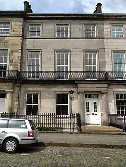 | |||
| 7 Royal Terrace Including Railings And Boundary Walls | 55°57′24″N 3°10′49″W / 55.956728°N 3.180176°W | Category A | 49805 | Upload Photo | |||
| 29 Royal Terrace Including Railings And Boundary Walls | 55°57′24″N 3°10′37″W / 55.95665°N 3.177066°W | Category A | 49820 |  | |||
| 34 Royal Terrace Including Railings And Boundary Walls | 55°57′24″N 3°10′35″W / 55.956621°N 3.176265°W | Category A | 49826 | Upload Photo | |||
| 40 Royal Terrace Including Railings And Boundary Walls | 55°57′24″N 3°10′31″W / 55.956613°N 3.175319°W | Category A | 49832 |  | |||
| 32 George Square, University Of Edinburgh, Arts Faculty, George Square Theatre (Block E) | 55°56′34″N 3°11′17″W / 55.942885°N 3.188177°W | Category B | 50190 |  | |||
| 36 George Square, University Of Edinburgh, Arts Faculty, Adam Ferguson (Block D) | 55°56′35″N 3°11′15″W / 55.943099°N 3.187415°W | Category B | 50188 | Upload Photo | |||
| 15, 15B And 15C Dalkeith Road, Scottish Widows Fund And Life Assurance Society Head Office, Including Landscaping, Moat And Boundary Walls | 55°56′25″N 3°10′28″W / 55.940277°N 3.174328°W | Category A | 50213 | Upload Photo | |||
| Shore Road, Port Edgar, Power Station | 55°59′32″N 3°24′37″W / 55.992139°N 3.410284°W | Category C(S) | 50856 | Upload Photo | |||
| Comiston Springs Water House Off Oxgangs Loan And Fox Spring Crescent | 55°54′39″N 3°13′04″W / 55.910914°N 3.217691°W | Category B | 27963 |  | |||
| Craigleith Road, Royal Victoria Hospital, Administration Block | 55°57′33″N 3°13′54″W / 55.959118°N 3.231602°W | Category B | 51008 | Upload Photo | |||
| 301-319 (Odd Nos) Cowgate And 1 And 2 High School Yards, Including Steps To East | 55°56′56″N 3°11′03″W / 55.948998°N 3.184136°W | Category B | 51174 | 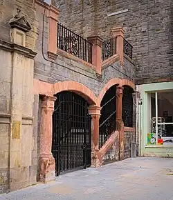 | |||
| 64 Princes Street, British Home Stores | 55°57′09″N 3°11′44″W / 55.952607°N 3.195681°W | Category B | 51249 | Upload Photo | |||
| 8 Sunbury Mews And 3 Sunbury Street | 55°57′05″N 3°13′12″W / 55.951488°N 3.219973°W | Category C(S) | 51344 | Upload Photo | |||
| 42 Pennywell Gardens, Muirhouse St Andrews Parish Church And Halls (Church Of Scotland) | 55°58′21″N 3°15′28″W / 55.972501°N 3.257905°W | Category C(S) | 51748 | Upload Photo |
Key
The scheme for classifying buildings in Scotland is:
- Category A: "buildings of national or international importance, either architectural or historic; or fine, little-altered examples of some particular period, style or building type."[1]
- Category B: "buildings of regional or more than local importance; or major examples of some particular period, style or building type, which may have been altered."[1]
- Category C: "buildings of local importance; lesser examples of any period, style, or building type, as originally constructed or moderately altered; and simple traditional buildings which group well with other listed buildings."[1]
In March 2016 there were 47,288 listed buildings in Scotland. Of these, 8% were Category A, and 50% were Category B, with the remaining 42% being Category C.[2]
See also
Notes
- ^ Sometimes known as OSGB36, the grid reference (where provided) is based on the British national grid reference system used by the Ordnance Survey.
• "Guide to National Grid". Ordnance Survey. Retrieved 12 December 2007.
• "Get-a-map". Ordnance Survey. Retrieved 17 December 2007. - ^ Historic Environment Scotland assign a unique alphanumeric identifier to each designated site in Scotland, for listed buildings this always begins with "LB", for example "LB12345".
References
- All entries, addresses and coordinates are based on data from Historic Scotland. This data falls under the Open Government Licence
- ^ a b c "What is Listing?". Historic Environment Scotland. Retrieved 29 May 2018.
- ^ Scotland's Historic Environment Audit 2016 (PDF). Historic Environment Scotland and the Built Environment Forum Scotland. pp. 15–16. Retrieved 29 May 2018.