Neuschönau
Neuschönau | |
|---|---|
 Panorama of Neuschönau Municipality. | |
 Coat of arms | |
Location of Neuschönau within Freyung-Grafenau district  | |
 Neuschönau  Neuschönau | |
| Coordinates: 48°53′04″N 13°28′40″E / 48.88444°N 13.47778°E | |
| Country | Germany |
| State | Bavaria |
| Admin. region | Niederbayern |
| District | Freyung-Grafenau |
| Government | |
| • Mayor (2020–26) | Alfons Schinabeck[1] (CSU) |
| Area | |
• Total | 27.54 km2 (10.63 sq mi) |
| Highest elevation | 1,350 m (4,430 ft) |
| Lowest elevation | 650 m (2,130 ft) |
| Population (2024-12-31)[2] | |
• Total | 2,191 |
| • Density | 80/km2 (210/sq mi) |
| Time zone | UTC+01:00 (CET) |
| • Summer (DST) | UTC+02:00 (CEST) |
| Postal codes | 94556 |
| Dialling codes | 08558, 08552 (Altschönau) |
| Vehicle registration | FRG |
| Website | www.neuschoenau.de |
Neuschönau (pronounced [ˈnɔʏˌʃøːnaʊ], lit. 'New Schönau', in contrast to "Old Schönau") is a municipality in the district of Freyung-Grafenau, in the Lower Bavaria region of Bavaria, in Germany.
Points of interest
- Botanischer Garten der Nationalpark Bayerischer Wald — botanical garden.
- Lusen National Park Centre
- Baumwipfelpfad Neuschönau — tall contemporary wooden tower, with a spiral ramp for treetop walking.
- Hans-Eisenmann-Haus — visitor centre.
Gallery
-
 Panorama of Neuschönau Municipality.
 -
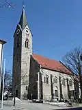 Saint Anne parish church, Neuschönau — a Cultural Heritage monument.
 -
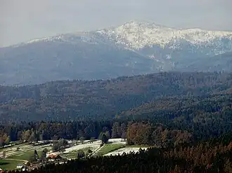 Panorama of Neuschönau Municipality: mountain Großer Rachel
 -
 Hans-Eisenmann-Haus visitor centre, footbridge to Baumwipfelpfad Neuschönau (right).
 -
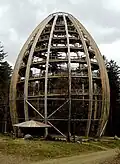 Baumwipfelpfad Neuschönau — wooden tower profile.
 -
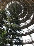 Baumwipfelpfad Neuschönau — walkway ramps into the tree tops.
 -
 Baumwipfelpfad Neuschönau — walkway ramps into the tree tops.
References
Wikimedia Commons has media related to Neuschönau.
- ^ Liste der ersten Bürgermeister/Oberbürgermeister in kreisangehörigen Gemeinden, Bayerisches Landesamt für Statistik, 15 July 2021.
- ^ "Gemeinden, Kreise und Regierungsbezirke in Bayern, Einwohnerzahlen am 31. Dezember 2024; Basis Zensus 2022" [Municipalities, counties, and administrative districts in Bavaria; Based on the 2022 Census] (CSV) (in German). Bayerisches Landesamt für Statistik.
Towns and municipalities in Freyung-Grafenau | ||
|---|---|---|