Puclice
Puclice | |
|---|---|
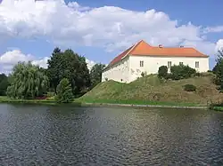 Former fort | |
 Flag  Coat of arms | |
 Puclice Location in the Czech Republic | |
| Coordinates: 49°33′13″N 13°1′10″E / 49.55361°N 13.01944°E | |
| Country | |
| Region | Plzeň |
| District | Domažlice |
| First mentioned | 1379 |
| Area | |
• Total | 13.85 km2 (5.35 sq mi) |
| Elevation | 398 m (1,306 ft) |
| Population (2025-01-01)[1] | |
• Total | 365 |
| • Density | 26/km2 (68/sq mi) |
| Time zone | UTC+1 (CET) |
| • Summer (DST) | UTC+2 (CEST) |
| Postal code | 345 61 |
| Website | www |
Puclice is a municipality and village in Domažlice District in the Plzeň Region of the Czech Republic. It has about 400 inhabitants.
Puclice lies approximately 15 kilometres (9 mi) north-east of Domažlice, 34 km (21 mi) south-west of Plzeň, and 117 km (73 mi) south-west of Prague.
Administrative division
Puclice consists of three municipal parts (in brackets population according to the 2021 census):[2]
- Puclice (253)
- Doubrava (47)
- Malý Malahov (60)
Demographics
| Year | Pop. | ±% |
|---|---|---|
| 1869 | 628 | — |
| 1880 | 668 | +6.4% |
| 1890 | 661 | −1.0% |
| 1900 | 709 | +7.3% |
| 1910 | 800 | +12.8% |
| 1921 | 729 | −8.9% |
| 1930 | 714 | −2.1% |
| 1950 | 450 | −37.0% |
| 1961 | 476 | +5.8% |
| 1970 | 431 | −9.5% |
| 1980 | 416 | −3.5% |
| 1991 | 355 | −14.7% |
| 2001 | 302 | −14.9% |
| 2011 | 334 | +10.6% |
| 2021 | 360 | +7.8% |
| Source: Censuses[3][4] | ||
References
- ^ "Population of Municipalities – 1 January 2025". Czech Statistical Office. 2025-05-16.
- ^ "Public Census 2021 – basic data". Public Database (in Czech). Czech Statistical Office. 2022.
- ^ "Historický lexikon obcí České republiky 1869–2011" (in Czech). Czech Statistical Office. 2015-12-21.
- ^ "Population Census 2021: Population by sex". Public Database. Czech Statistical Office. 2021-03-27.
External links
Wikimedia Commons has media related to Puclice.