Boer, Netherlands
Boer | |
|---|---|
Village | |
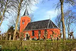 St Mary's church | |
 Coat of arms | |
 Location in the Franekeradeel municipality | |
 Boer Location in the Netherlands  Boer Boer (Netherlands) | |
| Coordinates: 53°12′55″N 5°33′52″E / 53.21528°N 5.56444°E | |
| Country | Netherlands |
| Province | Friesland |
| Municipality | Waadhoeke |
| Area | |
• Total | 2.11 km2 (0.81 sq mi) |
| Elevation | 0.3 m (1.0 ft) |
| Population (2021)[1] | |
• Total | 45 |
| • Density | 21/km2 (55/sq mi) |
| Postal code | 8806[1] |
| Dialing code | 0517 |
Boer is a small village in Waadhoeke in the province of Friesland, the Netherlands. It had a population of around 48 in 2014.[3] Before 2018, the village was part of the Franekeradeel municipality.[4]
The village was first mentioned in 1402 as Burstera Rede, and means "farm house".[5] The Dutch Reformed church was built around 1500 and as pigeon holes. The church does not look that old, because a layer of plaster had been applied to hide the somewhat ruinous stones.[6]
Boer was home to 93 people in 1840.[4]
Gallery
-
 Clergy house in Boer
 -
 Boer behind the trees
References
- ^ a b c "Kerncijfers wijken en buurten 2021". Central Bureau of Statistics. Retrieved 4 April 2022.
- ^ "Postcodetool for 8806KA". Actueel Hoogtebestand Nederland (in Dutch). Het Waterschapshuis. Retrieved 4 April 2022.
- ^ Aantal inwoners per buurt/dorp Archived 2012-08-12 at the Wayback Machine - Franekeradeel
- ^ a b "Dongjum-Boer". Plaatsengids (in Dutch). Retrieved 4 April 2022.
- ^ "Boer - (geografische naam)". Etymologiebank (in Dutch). Retrieved 4 April 2022.
- ^ "Boer". Friesland Wonderland (in Dutch). Retrieved 4 April 2022.
Wikimedia Commons has media related to Boer, Waadhoeke.