Dimaro
Dimaro | |
|---|---|
| Comune di Dimaro | |
 View of Dimaro and Carciato from Bolentina. | |
 Coat of arms | |
Location of Dimaro | |
 Dimaro Location of Dimaro in Italy  Dimaro Dimaro (Trentino-Alto Adige/Südtirol) | |
| Coordinates: 46°20′N 10°52′E / 46.333°N 10.867°E | |
| Country | Italy |
| Region | Trentino-Alto Adige/Südtirol |
| Province | Trentino (TN) |
| Frazioni | Folgarida, Carciato |
| Area | |
• Total | 28.3 km2 (10.9 sq mi) |
| Elevation | 766 m (2,513 ft) |
| Population (Dec. 2004) | |
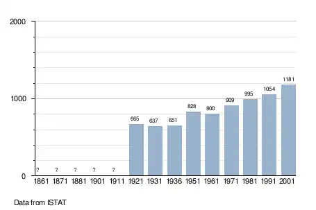
• Total | 1,193 |
| • Density | 42/km2 (110/sq mi) |
| Demonym | Dimari |
| Time zone | UTC+1 (CET) |
| • Summer (DST) | UTC+2 (CEST) |
| Postal code | 38025 |
| Dialing code | 0463 |
| Website | Official website |
Dimaro (in local dialect: Dimàr) is a comune (municipality) in Trentino in the northern Italian region Trentino-Alto Adige/Südtirol, located about 66 kilometres (41 mi) northwest of Trento. As of 31 December 2004, it had a population of 1,193 and an area of 28.3 square kilometres (10.9 sq mi).[2]
The municipality of Dimaro contains the frazioni (subdivisions, mainly villages and hamlets) Folgarida and Carciato.
Dimaro borders the following municipalities: Malè, Commezzadura, Monclassico.
Demographic evolution
References
- ^ "Superficie di Comuni Province e Regioni italiane al 9 ottobre 2011". Italian National Institute of Statistics. Retrieved 16 March 2019.
- ^ All demographics and other statistics: Italian statistical institute Istat.
External links

- (in Italian) Homepage of the city
