Hipsheim
Hipsheim Hípse | |
|---|---|
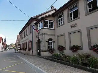 The town hall in Hipsheim | |
.svg.png) Coat of arms | |
Location of Hipsheim | |
 Hipsheim  Hipsheim | |
| Coordinates: 48°28′02″N 7°40′36″E / 48.4672°N 7.6767°E | |
| Country | France |
| Region | Grand Est |
| Department | Bas-Rhin |
| Arrondissement | Sélestat-Erstein |
| Canton | Erstein |
| Intercommunality | CC Canton d'Erstein |
| Government | |
| • Mayor (2020–2026) | Philippe Rome[1] |
Area 1 | 4.52 km2 (1.75 sq mi) |
| Population (2022)[2] | 1,014 |
| • Density | 220/km2 (580/sq mi) |
| Time zone | UTC+01:00 (CET) |
| • Summer (DST) | UTC+02:00 (CEST) |
| INSEE/Postal code | 67200 /67150 |
| Elevation | 145–152 m (476–499 ft) |
| 1 French Land Register data, which excludes lakes, ponds, glaciers > 1 km2 (0.386 sq mi or 247 acres) and river estuaries. | |
Hipsheim (French pronunciation: [ipsaim]) is a commune in the southeast of the Bas-Rhin department in Alsace in north-eastern France.[3]
Hipsheim is located some ten kilometres (six miles) to the south of Strasbourg.
Landmarks
- The 18th-century church of Saint Ludan has a 13th-century tower[4] near to the departmental road RD1083 (formerly RD 83)
- The Chapel of Saint Wendelin.[5]
See also
References
- ^ "Répertoire national des élus: les maires" (in French). data.gouv.fr, Plateforme ouverte des données publiques françaises. 13 September 2022.
- ^ "Populations de référence 2022" (in French). The National Institute of Statistics and Economic Studies. 19 December 2024.
- ^ INSEE commune file
- ^ Base Mérimée: Eglise paroissiale Saint-Georges ou église Saint-Ludan dite Scheerkirche, Ministère français de la Culture. (in French)
- ^ Base Mérimée: Chapelle Saint-Wendelin, Ministère français de la Culture. (in French)
Wikimedia Commons has media related to Hipsheim.