Juodkiškiai Reservoir
| Juodkiškiai Reservoir | |
|---|---|
| Juodkiškių tvenkinys (Lithuanian) | |
 | |
 Juodkiškiai Reservoir  Juodkiškiai Reservoir | |
| Location | Kėdainiai District Municipality, Lithuania |
| Coordinates | 55°17′17″N 24°02′28″E / 55.28806°N 24.04111°E |
| Part of | Obelis→ Nevėžis→ Neman→ Baltic Sea |
| Primary inflows | Obelis, Malčius, Koliupė |
| Primary outflows | Obelis |
| First flooded | 1980 |
| Max. length | 3.85 km (2.39 mi)[1] |
| Max. width | 0.32 km (0.20 mi)[1] |
| Surface area | 0.834 km2 (0.322 sq mi)[1] |
| Average depth | 4.6 m (15 ft)[1] |
| Max. depth | 12 m (39 ft)[1] |
| Water volume | 0.004395 km3 (0.001054 cu mi)[1] |
| Shore length1 | 15.2 km (9.4 mi)[1] |
| Surface elevation | 43 m (141 ft) |
| Settlements | Taučiūnai, Koliupė |
| 1 Shore length is not a well-defined measure. | |
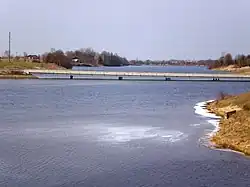
The Juodkiškiai Reservoir is an artificial lake in Kėdainiai District Municipality, central Lithuania. It is located 2 kilometres (1.2 mi) east from Kėdainiai, next to Taučiūnai village.[2] It was created in 1980, when a dam on the Obelis river was built next to Juodkiškiai hamlet.[1] In 1995, the dam was reconstructed and a small hydroelectric plant (of 510 kW) built.
Shores of the reservoir are low; agriculture lands stretch around the lake. The Bubliai Reservoir and some smaller reservoirs (the Koliupė Reservoir, the Malčius Reservoir) empty into the Juodkiškiai Reservoir. The A8 highway crosses the lake.