Partutovice
Partutovice | |
|---|---|
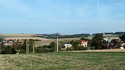 View from the south | |
 Flag  Coat of arms | |
 Partutovice Location in the Czech Republic | |
| Coordinates: 49°37′53″N 17°42′29″E / 49.63139°N 17.70806°E | |
| Country | |
| Region | Olomouc |
| District | Přerov |
| First mentioned | 1412 |
| Area | |
• Total | 10.08 km2 (3.89 sq mi) |
| Elevation | 410 m (1,350 ft) |
| Population (2025-01-01)[1] | |
• Total | 533 |
| • Density | 53/km2 (140/sq mi) |
| Time zone | UTC+1 (CET) |
| • Summer (DST) | UTC+2 (CEST) |
| Postal code | 753 01 |
| Website | www |
Partutovice (German: Bartelsdorf) is a municipality and village in Přerov District in the Olomouc Region of the Czech Republic. It has about 500 inhabitants.
Partutovice lies approximately 27 kilometres (17 mi) north-east of Přerov, 34 km (21 mi) east of Olomouc, and 242 km (150 mi) east of Prague.
History
The first written mention of Partutovice is from 1412.[2]
Demographics
| Year | Pop. | ±% |
|---|---|---|
| 1869 | 493 | — |
| 1880 | 458 | −7.1% |
| 1890 | 517 | +12.9% |
| 1900 | 500 | −3.3% |
| 1910 | 499 | −0.2% |
| 1921 | 504 | +1.0% |
| 1930 | 484 | −4.0% |
| 1950 | 406 | −16.1% |
| 1961 | 449 | +10.6% |
| 1970 | 419 | −6.7% |
| 1980 | 452 | +7.9% |
| 1991 | 476 | +5.3% |
| 2001 | 486 | +2.1% |
| 2011 | 496 | +2.1% |
| 2021 | 480 | −3.2% |
| Source: Censuses[3][4] | ||
Sights
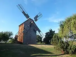
The main landmark of Partutovice is a wooden windmill built in 1837.[5]
References
- ^ "Population of Municipalities – 1 January 2025". Czech Statistical Office. 2025-05-16.
- ^ "O obci" (in Czech). Obec Partutovice. Retrieved 2022-02-03.
- ^ "Historický lexikon obcí České republiky 1869–2011" (in Czech). Czech Statistical Office. 2015-12-21.
- ^ "Population Census 2021: Population by sex". Public Database. Czech Statistical Office. 2021-03-27.
- ^ "Obec Partutovice" (in Czech). Obec Partutovice. Retrieved 2022-02-03.
External links
Wikimedia Commons has media related to Partutovice.