Vyklantice
Vyklantice | |
|---|---|
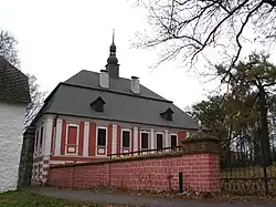 Vyklantice Castle | |
 Flag  Coat of arms | |
 Vyklantice Location in the Czech Republic | |
| Coordinates: 49°33′16″N 15°2′26″E / 49.55444°N 15.04056°E | |
| Country | |
| Region | Vysočina |
| District | Pelhřimov |
| First mentioned | 1410 |
| Area | |
• Total | 6.81 km2 (2.63 sq mi) |
| Elevation | 602 m (1,975 ft) |
| Population (2025-01-01)[1] | |
• Total | 147 |
| • Density | 22/km2 (56/sq mi) |
| Time zone | UTC+1 (CET) |
| • Summer (DST) | UTC+2 (CEST) |
| Postal codes | 394 27, 395 01 |
| Website | www |
Vyklantice is a municipality in Pelhřimov District in the Vysočina Region of the Czech Republic. It has about 100 inhabitants.
Vyklantice lies approximately 20 kilometres (12 mi) north-west of Pelhřimov, 44 km (27 mi) north-west of Jihlava, and 74 km (46 mi) south-east of Prague.
Administrative division
Vyklantice consists of six municipal parts (in brackets population according to the 2021 census):[2]
- Staré Vyklantice (76)
- Nové Vyklantice (13)
- Kateřinky (16)
- Nový Smrdov (11)
- Petrovsko (7)
- Starý Smrdov (17)
Demographics
| Year | Pop. | ±% |
|---|---|---|
| 1869 | 826 | — |
| 1880 | 772 | −6.5% |
| 1890 | 723 | −6.3% |
| 1900 | 735 | +1.7% |
| 1910 | 662 | −9.9% |
| 1921 | 670 | +1.2% |
| 1930 | 597 | −10.9% |
| 1950 | 433 | −27.5% |
| 1961 | 469 | +8.3% |
| 1970 | 380 | −19.0% |
| 1980 | 296 | −22.1% |
| 1991 | 225 | −24.0% |
| 2001 | 186 | −17.3% |
| 2011 | 163 | −12.4% |
| 2021 | 140 | −14.1% |
| Source: Censuses[3][4] | ||
References
- ^ "Population of Municipalities – 1 January 2025". Czech Statistical Office. 2025-05-16.
- ^ "Public Census 2021 – basic data". Public Database (in Czech). Czech Statistical Office. 2022.
- ^ "Historický lexikon obcí České republiky 1869–2011" (in Czech). Czech Statistical Office. 2015-12-21.
- ^ "Population Census 2021: Population by sex". Public Database. Czech Statistical Office. 2021-03-27.
External links
Wikimedia Commons has media related to Vyklantice.