Azopardo River
| Azopardo River | |
|---|---|
 | |
| Native name | Río Azopardo (Spanish) |
| Location | |
| Country | Chile |
| Physical characteristics | |
| Source | |
| • location | Cami Lake (also called Fagnano Lake) |
| • elevation | 140 m (460 ft) (see Cami Lake) |
| Mouth | |
• location | Almirantazgo Fjord (Pacific Ocean) |
• elevation | 0 m (0 ft) |
| Length | 11 km (6.8 mi)[1] |
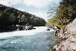
The Azopardo River (Spanish: Río Azopardo), is a river in Isla Grande de Tierra del Fuego, Chile at the southern tip of South America. It flows in a westerly direction and drains the waters of Fagnano Lake (also called Cami Lake) into Almirantazgo Fjord.
The Azopardo is the northern limit of Yendegaia National Park.
See also
References
- ^ river length Archived July 22, 2011, at the Wayback Machine
| Rivers | ||
|---|---|---|
| Waterfalls | ||
| Lakes | ||
| Glaciers | ||
54°28′26″S 68°58′23″W / 54.4739°S 68.9731°W