Beinn Dearg Mòr
| Beinn Dearg Mòr | |
|---|---|
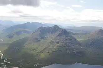 Beinn Dearg Mor from Sail Liath, August 2009 | |
| Highest point | |
| Elevation | 906.3 m (2,973 ft) |
| Prominence | 568 m (1,864 ft) |
| Listing | Corbett, Marilyn |
| Coordinates | 57°45′56″N 5°18′36″W / 57.7655°N 5.3099°W |
| Naming | |
| English translation | Big red mountain |
| Language of name | Gaelic |
| Pronunciation | Scottish Gaelic: [peɲ ˈtʲɛɾɛk moːɾ] |
| Geography | |
| Location | Dundonnell and Fisherfield Forest, Scotland |
| OS grid | NH03217993 |
| Topo map | OS Landranger 19 |
Beinn Dearg Mòr is a Corbett in the middle of the Fisherfield Forest, near Dundonnell and Northwest Highlands in Scotland. It rises to an elevation of 906 metres (2,972 ft) above sea level.[1]
Beinn Dearg Mòr and Beinn Dearg Bheag, its neighbour, sit across the Loch na Sealga (also referred to as na Sheallag) from An Teallach, "The Anvil."[2]
References
- ^ Rowan, Alan. "Peak of the Week: Beinn Dearg Mor is an exquisite mountain in a land of giants – Scotland Now". scotlandnow.dailyrecord.co.uk. Retrieved 21 October 2019.
- ^ "Beinn Dearg Mor and Beinn Dearg Bheag, from Gruinard". Walkhighlands. Retrieved 21 October 2019.
Wikimedia Commons has media related to Beinn Dearg Mòr.