Le Bicorne
| Le Bicorne | |
|---|---|
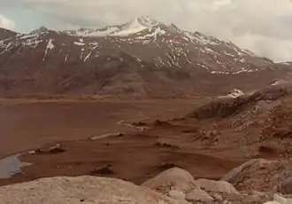 Le Bicorne rising in the background. | |
| Highest point | |
| Elevation | 1,202 m (3,944 ft)[1] |
| Prominence | 147 m (482 ft)[1] |
| Coordinates | 49°35′16″S 68°53′01″E / 49.58778°S 68.88361°E[1] |
| Geography | |
 Le Bicorne Location in Kerguelen | |
| Location | Grande Terre, Kerguelen Islands, French Southern and Antarctic Lands |
| Climbing | |
| First ascent | Unknown |
Le Bicorne is a mountain in the French Southern and Antarctic Lands. Located in the Rallier du Baty Peninsula, near the southwestern shore of Kerguelen, it rises to a height of 1,202 metres (3,944 ft) above sea level.[2]
This mountain is the highest point on the peninsula and a prominent landmark. It was first named by French polar explorer Albert Bauer during an exploration of the Cook Glacier in 1961-1962. Bauer deemed that the two peaks atop the mountain resembled the bicorne hat worn by the members of the École polytechnique to which he belonged.[3]
See also
References
- ^ a b c "Le Bicorne". PeakVisor.
- ^ Google Earth
- ^ Gracie Delépine, Toponymie des Terres Australes Archived 2016-03-06 at the Wayback Machine, éditions La Documentation française, Paris, 1973
External links
| Islands |
|  |
|---|---|---|
| Peninsulas and Presque-isles |
| |
| Mountains |
| |
| Glaciers |
| |
| Watercourses |
| |
| Principal Lakes |
| |
| Main gulfs, bays and fjords |
| |
| Locations |
| |