Charazani
Charazani Charasani | |
|---|---|
 Charazani | |
 Charazani Location in Bolivia | |
| Coordinates: 15°10′38″S 68°59′18″W / 15.17722°S 68.98833°W | |
| Country | |
| Department | La Paz Department |
| Province | Bautista Saavedra Province |
| Elevation | 10,500 ft (3,200 m) |
| Population (2001)census | |
• Total | 501 |
| Time zone | UTC-4 (BOT) |
| Climate | Cwb |
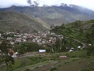
Charazani or Charasani is a small town in the South American Andes in Bolivia.
Location
Charazani is the capital of Bautista Saavedra Province and central town of the municipality. It is situated on a spur at an elevation of 3,200 m amsl between Cordillera Muñecas in the south and Cordillera Apolabamba in the north, on a Mapiri River tributary which itself flows towards Beni River.
Infrastructure
Charazani is located 254 km north-west of La Paz, the capital of La Paz Department. From La Paz, the asphaltic highway Ruta 2 goes 70 km north-west to Huarina, where the asphaltic Ruta 16 branches south-west for another 97 km along Lake Titicaca till Escoma. From Escoma a dirt road goes north and reaches Charazani after 87 km.
The weekly village market attracts vendors and visitors from a wide area. The market makes Charazani economically the most significant locality in the Charazani valley.[1]
Population
The population of Charazani has risen by 20% in the recent decade, from 501 inhabitants (2001 census)[2] to 604 inhabitants (2008 est.). Currently, La Paz's Gobernación shows that Charazani has 11 761 inhabitants in the whole municipality. Most inhabitants of the Charazani municipality live in poverty: 91,5% of the municipality are unable to suffice their basic needs.
It boasts of a population that speaks Quechua, which is also learned at school. About 76.5% of the municipality speak Quechua as a primary language followed by Aymara speakers, 13%.
Charazani is a major locality for the Kallawaya, a UNESCO Intangible Cultural Heritage culture of ritualistic healers.
Climate
| Climate data for Charazani | |||||||||||||
|---|---|---|---|---|---|---|---|---|---|---|---|---|---|
| Month | Jan | Feb | Mar | Apr | May | Jun | Jul | Aug | Sep | Oct | Nov | Dec | Year |
| Mean daily maximum °C (°F) | 18.1 (64.6) | 18.0 (64.4) | 18.2 (64.8) | 18.6 (65.5) | 17.9 (64.2) | 18.1 (64.6) | 18.3 (64.9) | 19.3 (66.7) | 19.3 (66.7) | 19.7 (67.5) | 20.0 (68.0) | 18.7 (65.7) | 18.7 (65.6) |
| Mean daily minimum °C (°F) | 8.3 (46.9) | 8.6 (47.5) | 8.4 (47.1) | 6.8 (44.2) | 4.6 (40.3) | 2.9 (37.2) | 3.6 (38.5) | 4.5 (40.1) | 6.1 (43.0) | 7.3 (45.1) | 7.9 (46.2) | 8.5 (47.3) | 6.5 (43.6) |
| Average precipitation mm (inches) | 76 (3.0) | 72 (2.8) | 50 (2.0) | 31 (1.2) | 13 (0.5) | 9 (0.4) | 8 (0.3) | 10 (0.4) | 26 (1.0) | 29 (1.1) | 30 (1.2) | 45 (1.8) | 399 (15.7) |
| Source 1: Dirección General de Riego Vice Ministerio de Desarrollo Rural y Riego[3] | |||||||||||||
| Source 2: National Meteorology and Hydrology Service of Peru (precipitation)[4] | |||||||||||||
References
- ^ Schoop, Wolfgang (1982). "Güteraustausch und regionale Mobilität im Kallawaya-Tal (Bolivien)". Erdkunde. 36 (4). doi:10.3112/erdkunde.1982.04.03. ISSN 0014-0015.
- ^ Observatorio Bolivia Democrática
- ^ "Abro Charazani PDF". Dirección General de Riego Vice Ministerio de Desarrollo Rural y Riego. Retrieved 11 June 2024.
- ^ "anexos atlas climatico" (PDF). National Meteorology and Hydrology Service of Peru. Retrieved 13 June 2024.
External links
15°10′38″S 68°59′18″W / 15.17722°S 68.98833°W
