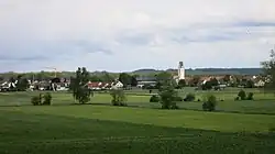
Dietenheim
Dietenheim | |
|---|---|
 | |
 Coat of arms | |
Location of Dietenheim within Alb-Donau-Kreis district  | |
 Dietenheim  Dietenheim | |
| Coordinates: 48°12′43″N 10°4′24″E / 48.21194°N 10.07333°E | |
| Country | Germany |
| State | Baden-Württemberg |
| Admin. region | Tübingen |
| District | Alb-Donau-Kreis |
| Government | |
| • Mayor (2020–28) | Christopher Eh[1] (Ind.) |
| Area | |
• Total | 18.75 km2 (7.24 sq mi) |
| Elevation | 513 m (1,683 ft) |
| Population (2023-12-31)[2] | |
• Total | 6,832 |
| • Density | 360/km2 (940/sq mi) |
| Time zone | UTC+01:00 (CET) |
| • Summer (DST) | UTC+02:00 (CEST) |
| Postal codes | 89165 |
| Dialling codes | 07347 |
| Vehicle registration | UL |
| Website | www.dietenheim.de |
Dietenheim (German pronunciation: [ˈdiːtn̩haɪm] ⓘ) is a town in the district of Alb-Donau in Baden-Württemberg in Germany. It is situated on the left bank of the Iller, 22 km (14 mi) south of Ulm.
References
- ^ Aktuelle Wahlergebnisse, Staatsanzeiger, accessed 11 September 2021.
- ^ "Bevölkerung nach Nationalität und Geschlecht am 31. Dezember 2023 (Fortschreibung auf Basis des Zensus 2022)" [Population by nationality and sex as of December 31, 2023 (updated based on the 2022 census)] (CSV) (in German). Statistisches Landesamt Baden-Württemberg.