Dudín
Dudín | |
|---|---|
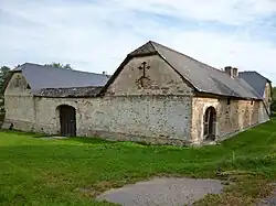 Former inn, a cultural monument | |
 Flag  Coat of arms | |
 Dudín Location in the Czech Republic | |
| Coordinates: 49°27′4″N 15°23′52″E / 49.45111°N 15.39778°E | |
| Country | |
| Region | Vysočina |
| District | Jihlava |
| First mentioned | 1226 |
| Area | |
• Total | 8.36 km2 (3.23 sq mi) |
| Elevation | 627 m (2,057 ft) |
| Population (2025-01-01)[1] | |
• Total | 198 |
| • Density | 24/km2 (61/sq mi) |
| Time zone | UTC+1 (CET) |
| • Summer (DST) | UTC+2 (CEST) |
| Postal code | 588 05 |
| Website | www |
Dudín (Czech pronunciation: [ˈduɟiːn]) is a municipality and village in Jihlava District in the Vysočina Region of the Czech Republic. It has about 200 inhabitants.
Dudín lies approximately 17 kilometres (11 mi) north-west of Jihlava and 99 km (62 mi) south-east of Prague.
Demographics
| Year | Pop. | ±% |
|---|---|---|
| 1869 | 482 | — |
| 1880 | 556 | +15.4% |
| 1890 | 522 | −6.1% |
| 1900 | 468 | −10.3% |
| 1910 | 460 | −1.7% |
| 1921 | 428 | −7.0% |
| 1930 | 374 | −12.6% |
| 1950 | 286 | −23.5% |
| 1961 | 238 | −16.8% |
| 1970 | 168 | −29.4% |
| 1980 | 150 | −10.7% |
| 1991 | 143 | −4.7% |
| 2001 | 148 | +3.5% |
| 2011 | 174 | +17.6% |
| 2021 | 175 | +0.6% |
| Source: Censuses[2][3] | ||
References
- ^ "Population of Municipalities – 1 January 2025". Czech Statistical Office. 2025-05-16.
- ^ "Historický lexikon obcí České republiky 1869–2011" (in Czech). Czech Statistical Office. 2015-12-21.
- ^ "Population Census 2021: Population by sex". Public Database. Czech Statistical Office. 2021-03-27.
External links
Wikimedia Commons has media related to Dudín.