Ferland-et-Boilleau
Ferland-et-Boilleau | |
|---|---|
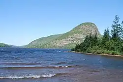 Lake Ha!Ha! in Ferland-et-Boilleau | |
 | |
 Ferland-et-Boilleau Location in Saguenay–Lac-Saint-Jean Quebec. | |
| Coordinates: 48°06′N 70°50′W / 48.100°N 70.833°W[1] | |
| Country | |
| Province | |
| Region | Saguenay–Lac-Saint-Jean |
| RCM | Le Fjord-du-Saguenay |
| Constituted | January 1, 1978 |
| Government | |
| • Mayor | Carmen Simard |
| • Federal riding | Chicoutimi—Le Fjord |
| • Prov. riding | Dubuc |
| Area | |
• Total | 407.30 km2 (157.26 sq mi) |
| • Land | 383.09 km2 (147.91 sq mi) |
| Population (2021)[3] | |
• Total | 632 |
| • Density | 1.6/km2 (4/sq mi) |
| • Pop (2016–21) | |
| • Dwellings | 319 |
| Time zone | UTC−5 (EST) |
| • Summer (DST) | UTC−4 (EDT) |
| Postal code(s) | |
| Area codes | 418 and 581 |
| Highways | |
| Website | www |
Ferland-et-Boilleau (French pronunciation: [fɛʁlɑ̃ e bwalo]) is a municipality in the Canadian province of Quebec, located in Le Fjord-du-Saguenay Regional County Municipality. This municipality is located on Route 381 relatively near Saguenay.
Climate
| Climate data for Ferland-et-Boilleau | |||||||||||||
|---|---|---|---|---|---|---|---|---|---|---|---|---|---|
| Month | Jan | Feb | Mar | Apr | May | Jun | Jul | Aug | Sep | Oct | Nov | Dec | Year |
| Record high °C (°F) | 16 (61) | 15 (59) | 24 (75) | 28.5 (83.3) | 33.9 (93.0) | 37 (99) | 36 (97) | 35 (95) | 32.2 (90.0) | 26 (79) | 20.6 (69.1) | 14 (57) | 37 (99) |
| Mean daily maximum °C (°F) | −9.7 (14.5) | −7.2 (19.0) | −0.1 (31.8) | 7.6 (45.7) | 16.5 (61.7) | 21.9 (71.4) | 24.2 (75.6) | 22.7 (72.9) | 16.8 (62.2) | 9.6 (49.3) | 1.7 (35.1) | −5.9 (21.4) | 8.2 (46.8) |
| Daily mean °C (°F) | −17.3 (0.9) | −14.7 (5.5) | −7 (19) | 1.5 (34.7) | 9.3 (48.7) | 14.6 (58.3) | 17.2 (63.0) | 15.8 (60.4) | 10.6 (51.1) | 4.4 (39.9) | −3.1 (26.4) | −12.1 (10.2) | 1.6 (34.9) |
| Mean daily minimum °C (°F) | −24.7 (−12.5) | −22.1 (−7.8) | −13.8 (7.2) | −4.6 (23.7) | 2 (36) | 7.4 (45.3) | 10.2 (50.4) | 9 (48) | 4.3 (39.7) | −0.9 (30.4) | −7.9 (17.8) | −18.4 (−1.1) | −5 (23) |
| Record low °C (°F) | −46.7 (−52.1) | −43.9 (−47.0) | −38.5 (−37.3) | −30.5 (−22.9) | −11.1 (12.0) | −5 (23) | 0 (32) | −2 (28) | −7.8 (18.0) | −13.9 (7.0) | −27.8 (−18.0) | −42.5 (−44.5) | −46.7 (−52.1) |
| Average precipitation mm (inches) | 52.8 (2.08) | 48.5 (1.91) | 46.7 (1.84) | 50.8 (2.00) | 83.7 (3.30) | 92.3 (3.63) | 109.2 (4.30) | 98.2 (3.87) | 89.9 (3.54) | 73.9 (2.91) | 72 (2.8) | 75.5 (2.97) | 893.5 (35.18) |
| Source: Environment Canada[4] | |||||||||||||
References
- ^ "Banque de noms de lieux du Québec: Reference number 92774". toponymie.gouv.qc.ca (in French). Commission de toponymie du Québec.
- ^ a b Ministère des Affaires municipales, des Régions et de l'Occupation du territoire - Répertoire des municipalités: Ferland-et-Boilleau Archived 2014-08-26 at the Wayback Machine
- ^ a b "Ferland-et-Boilleau census profile". 2021 Census data. Statistics Canada. Retrieved 2022-04-25.
- ^ Environment Canada Canadian Climate Normals 1971–2000, accessed 14 May 2010
External links
![]() Media related to Ferland-et-Boilleau at Wikimedia Commons
Media related to Ferland-et-Boilleau at Wikimedia Commons
Places adjacent to Ferland-et-Boilleau | ||||||||||||||||
|---|---|---|---|---|---|---|---|---|---|---|---|---|---|---|---|---|
| ||||||||||||||||