San Juan de Girón
Girón San Juan Girón | |
|---|---|
 Nieves Chapel | |
.svg.png) Flag  Coat of arms | |
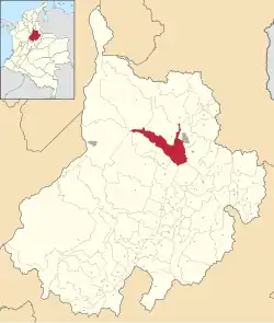 Location of the municipality and town of Girón in the Santander Department of Colombia | |
| Coordinates: 7°4′15″N 73°10′23″W / 7.07083°N 73.17306°W | |
| Country | Colombia |
| Department | Santander Department |
| Province | Soto |
| Founded | January 15, 1631 |
| Moved | December 30, 1968 |
| Founded by | Francisco Mantilla de los Ríos y Franco |
| Government | |
| • Mayor | Luis Alberto Quintero González |
| Area | |
| 493 km2 (190 sq mi) | |
| • Urban | 9.74 km2 (3.76 sq mi) |
| Elevation | 706 m (2,316 ft) |
| Population | |
| 206,005 | |
| • Density | 420/km2 (1,100/sq mi) |
| • Urban | 152,582 |
| • Urban density | 16,000/km2 (41,000/sq mi) |
| DANE | |
| Demonym | Gironés |
| Time zone | UTC-5 (Colombia Standard Time) |
| Area code | 57 + 7 |
| Website | Official website (in Spanish) |
San Juan de Girón (better known as Girón), formerly: Villa de los Caballeros de Girón,[3] is a municipality of the Santander Department, which is part of the Bucaramanga Metropolitan area in northeastern Colombia.[4]
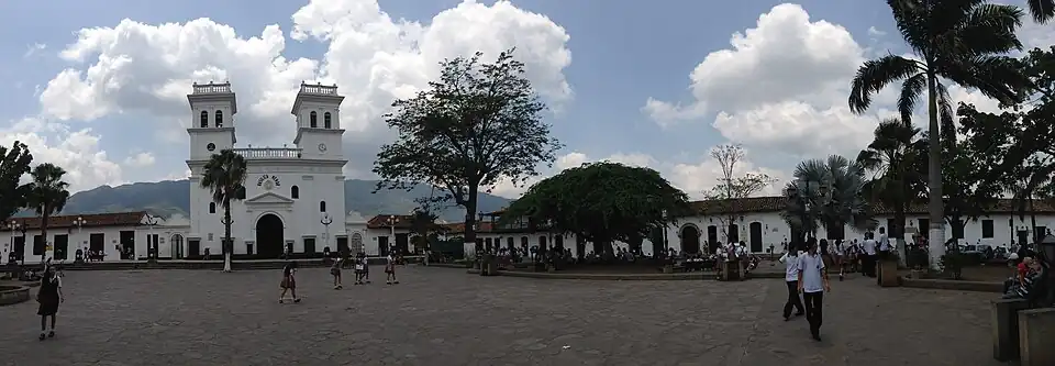
Pueblo Patrimonio
Girón was declared a Colombian Pueblo Patrimonio (heritage town) by the Colombian government in 2010.[5]
National Monument
The municipality is known National Monument of Colombia for its old sector characterized by its Spanish colonial architecture (cobblestone streets, houses with white walls, large dark brown and/or black doors, and clay tile roofs).[6]
Climate
| Climate data for San Juan de Girón (Llano Grande), elevation 777 m (2,549 ft), (1981–2010) | |||||||||||||
|---|---|---|---|---|---|---|---|---|---|---|---|---|---|
| Month | Jan | Feb | Mar | Apr | May | Jun | Jul | Aug | Sep | Oct | Nov | Dec | Year |
| Mean daily maximum °C (°F) | 30.9 (87.6) | 30.7 (87.3) | 30.7 (87.3) | 30.4 (86.7) | 30.8 (87.4) | 30.9 (87.6) | 31.0 (87.8) | 31.2 (88.2) | 31.2 (88.2) | 30.4 (86.7) | 30.4 (86.7) | 30.5 (86.9) | 30.8 (87.4) |
| Daily mean °C (°F) | 25.2 (77.4) | 25.4 (77.7) | 25.5 (77.9) | 25.3 (77.5) | 25.3 (77.5) | 25.2 (77.4) | 25.2 (77.4) | 25.3 (77.5) | 25.2 (77.4) | 25.1 (77.2) | 25.0 (77.0) | 25.1 (77.2) | 25.2 (77.4) |
| Mean daily minimum °C (°F) | 19.1 (66.4) | 19.5 (67.1) | 19.9 (67.8) | 20.0 (68.0) | 20.1 (68.2) | 19.6 (67.3) | 19.2 (66.6) | 19.4 (66.9) | 19.4 (66.9) | 19.6 (67.3) | 19.6 (67.3) | 19.2 (66.6) | 19.5 (67.1) |
| Average precipitation mm (inches) | 38.5 (1.52) | 70.8 (2.79) | 105.5 (4.15) | 95.0 (3.74) | 102.1 (4.02) | 71.7 (2.82) | 71.3 (2.81) | 75.7 (2.98) | 90.7 (3.57) | 119.6 (4.71) | 82.6 (3.25) | 25.1 (0.99) | 936.3 (36.86) |
| Average precipitation days | 6 | 7 | 11 | 14 | 15 | 13 | 14 | 15 | 15 | 15 | 10 | 5 | 139 |
| Average relative humidity (%) | 75 | 74 | 76 | 77 | 78 | 78 | 77 | 76 | 76 | 77 | 77 | 76 | 77 |
| Source: Instituto de Hidrologia Meteorologia y Estudios Ambientales[7] | |||||||||||||
References
- ^ "Resultados y proyecciones (2005-2020) del censo 2005". Retrieved 12 April 2020.
- ^ Citypopulation.de
- ^ Municipality Identification http://www.giron-santander.gov.co/nuestromunicipio.shtml?apc=mIxx-1-&m=f
- ^ "Información general". Nuestro Municipio (in Spanish). Alcaldía de Girón. Retrieved June 1, 2009.
- ^ "GUÍA: Red Turística de Pueblos Patrimonio de Colombia" (PDF). Fondo Nacional de Turismo de la República de Colombia - FONTUR. Dec 2020. Retrieved 29 Mar 2021.
- ^ "Girón - Mi municipio - Pasado, presente y futuro (in Spanish)". Alcaldía de Girón, Colombia. Retrieved 19 April 2024.
- ^ "Promedios Climatológicos 1981–2010" (in Spanish). Instituto de Hidrologia Meteorologia y Estudios Ambientales. Archived from the original on 15 August 2016. Retrieved 17 June 2024.