Grade II* listed buildings in Lancashire

There are over 20,000 Grade II* listed buildings in England. This page is a list of these buildings in the county of Lancashire by district.
Blackburn with Darwen


.jpg)


.jpg)

.jpg)

Blackpool
| Name | Location | Type | Completed [note 1] | Date designated | Grid ref.[note 2] Geo-coordinates | Entry number [note 3] | Image |
|---|---|---|---|---|---|---|---|
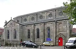
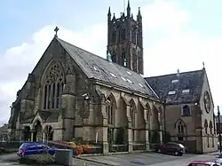
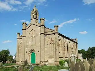
| Church of the Sacred Heart | Blackpool | Church | 1857 | 20 October 1983 | SD3072636433 53°49′10″N 3°03′13″W / 53.819537°N 3.053742°W | 1072015 | 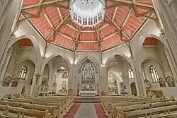 |
| Blackpool Grand Theatre | Blackpool | Theatre | 1894 | 26 January 1972 | SD3074936175 53°49′02″N 3°03′12″W / 53.817222°N 3.053334°W | 1280615 | 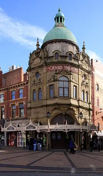 |
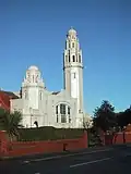
| Thanksgiving Shrine of Our Lady of Lourdes | Blackpool | Chapel | 1955–57 | 30 June 1999 | SD3318436774 53°49′23″N 3°00′59″W / 53.822924°N 3.016486°W | 1387319 |  |
| The Winter Gardens | Blackpool | Conservatory | 1875–78 | 10 October 1973 | SD3089236162 53°49′02″N 3°03′04″W / 53.817124°N 3.05116°W | 1072007 |  |
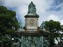
| Blackpool war memorial | Blackpool | War memorial | 1923 | 20 October 1983 | SD3057436469 53°49′11″N 3°03′22″W / 53.819843°N 3.0560634°W | 1072010 | .jpg) |
Burnley
| Name | Location | Type | Completed [note 1] | Date designated | Grid ref.[note 2] Geo-coordinates | Entry number [note 3] | Image |
|---|---|---|---|---|---|---|---|
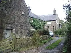
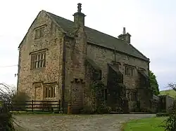
| Burwains | Briercliffe | Farmhouse | 1642 | 1 April 1953 | SD8873535779 53°49′05″N 2°10′21″W / 53.818165°N 2.172587°W | 1072659 | .jpg) |
| Extwistle Hall and attached garden wall | Briercliffe | Farmhouse | 16th to 17th century | 1 April 1953 | SD8760533800 53°48′01″N 2°11′23″W / 53.800352°N 2.18967°W | 1072655 | 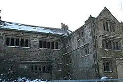 |
| Barcroft Hall with attached garden wall and entrance gateway | Cliviger | House | 16th to 17th century | 1 April 1953 | SD8656230417 53°46′12″N 2°12′19″W / 53.76992°N 2.205357°W | 1072668 |  |
| The Holme | Cliviger | House | Early 17th century | 1 April 1953 | SD8782428361 53°45′05″N 2°11′10″W / 53.751472°N 2.186128°W | 1362053 |  |
| Arched gateway and garden wall attached to south front of Shuttleworth Hall | Hapton | Gate | 17th century | 12 February 1985 | SD7838032229 53°47′09″N 2°19′47″W / 53.785928°N 2.329617°W | 1222599 | .jpg) |
| Hargrove Farmhouse | Padiham | Farmhouse | Early to mid-17th century | 28 August 1953 | SD7967234845 53°48′34″N 2°18′37″W / 53.809493°N 2.310182°W | 1237631 |  |
| Stockbridge House | Padiham | House | Mid-17th century | 28 August 1953 | SD7984633574 53°47′53″N 2°18′27″W / 53.798076°N 2.307456°W | 1274125 |  |
| The Great Barn | Hurstwood, Worsthorne-with-Hurstwood | Aisled barn | Late 16th century | 17 December 1968 | SD8814531368 53°46′43″N 2°10′53″W / 53.778506°N 2.181377°W | 1072638 |  |
| Hurstwood Hall | Hurstwood, Worsthorne-with-Hurstwood | Farmhouse | Post 1579 | 1 April 1953 | SD8812031340 53°46′42″N 2°10′54″W / 53.778254°N 2.181755°W | 1205736 |  |
| Burnley war memorial | Towneley Park | War memorial | 1926 | 19 November 1997 | SD8554630858 53°46′26″N 2°13′15″W / 53.773856°N 2.220792°W | 1247303 | 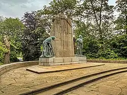 |
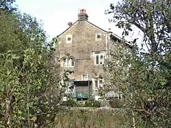
| Jackson's Farmhouse and cottage adjoining Jackson's Farmhouse and attached garden wall | Worsthorne-with-Hurstwood | Farmhouse | c. 1600 | 1 April 1953 | SD8765932442 53°47′17″N 2°11′20″W / 53.788148°N 2.188795°W | 1280581 | Feb2007.jpg) |
| Spenser House | Worsthorne-with-Hurstwood | Farmhouse | Mid-16th century | 1 April 1952 | SD8808531352 53°46′42″N 2°10′56″W / 53.778361°N 2.182287°W | 1280543 |  |
| Burnley Mechanics | Burnley | Mechanics institute | 1854–55 | 29 September 1977 | SD8398932409 53°47′16″N 2°14′40″W / 53.78775°N 2.244497°W | 1244905 |  |
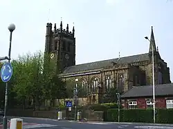
| Church of St Peter | Burnley | Church | 1791 | 10 November 1951 | SD8429632957 53°47′34″N 2°14′24″W / 53.792685°N 2.239866°W | 1022640 |  |
Chorley


Fylde


.jpg)
Hyndburn


Lancaster
.jpg)


.jpg)


.jpg)
.jpg)


.jpg)


Pendle
| Name | Location | Type | Completed [note 1] | Date designated | Grid ref.[note 2] Geo-coordinates | Entry number [note 3] | Image |
|---|---|---|---|---|---|---|---|
| Coates Hall | Barnoldswick | Apartment | Early 18th century | 5 July 1950 | SD8845647409 53°55′22″N 2°10′38″W / 53.922687°N 2.177267°W | 1258915 |  |
| Independent Methodist Church including steps and railings to street | Barnoldswick | Gate | 1892 | 29 January 1988 | SD8759146519 53°54′53″N 2°11′25″W / 53.914668°N 2.190402°W | 1273192 |  |
| Higherford Old Bridge | Barrowford | Packhorse bridge | 16th to 17th century | 6 June 1952 | SD8625240182 53°51′28″N 2°12′38″W / 53.857678°N 2.2105°W | 1273194 |  |
| Lamb Working Men's Club | Barrowford | House | 1696 | 6 June 1952 | SD8586139620 53°51′09″N 2°12′59″W / 53.852616°N 2.216418°W | 1073429 |  |
| Garden entrance to Hobstones Farmhouse | Colne | Wall | 1704 | 29 January 1988 | SD8821441682 53°52′16″N 2°10′51″W / 53.871208°N 2.180729°W | 1361721 |  Upload Photo |
| Hobstones Cottages, Hobstones Farmhouse | Colne | Farmhouse | Early 18th century | 29 January 1953 | SD8819541695 53°52′17″N 2°10′52″W / 53.871325°N 2.181019°W | 1272929 | Upload Photo |
| The Grammar School | Earby | School | 17th century | 18 May 1950 | SD9068546968 53°55′08″N 2°08′36″W / 53.918769°N 2.143312°W | 1272938 |  |
| Accornlee Hall Farmhouse | Foulridge | House | Late 17th century | 1 April 1953 | SD8942643011 53°52′59″N 2°09′44″W / 53.88318°N 2.162343°W | 1361742 |  |
| Ball House | Foulridge | House | 1627 | 1 April 1953 | SD8784142364 53°52′38″N 2°11′11″W / 53.877329°N 2.186429°W | 1073357 | Upload Photo |
| Church of St Mary, Newchurch in Pendle | Goldshaw Booth | Church | 1718 | 29 January 1988 | SD8230439373 53°51′01″N 2°16′14″W / 53.850286°N 2.270475°W | 1361745 |  |
| Sabden Great Hall | Goldshaw Booth | House | Early 17th century | 1 April 1953 | SD8105738352 53°50′28″N 2°17′22″W / 53.841066°N 2.289367°W | 1361707 | .jpg) |
| Ashlar Cottage, Ashlar House | Higham-with-West Close Booth | House | 1594 | 29 January 1988 | SD8217736995 53°49′44″N 2°16′20″W / 53.828909°N 2.272267°W | 1243453 |  |
| Lower Town House | Nelson | House | 17th century | 5 March 1952 | SD8777037457 53°50′00″N 2°11′14″W / 53.833224°N 2.187312°W | 1073369 |  |
| Greenhead Farmhouse | Reedley Hallows | House | Mid-17th century | 1 April 1953 | SD8292036059 53°49′14″N 2°15′39″W / 53.820522°N 2.260926°W | 1272792 |  |
| Wood End Farmhouse | Salterforth | Farmhouse | 1686 | 29 January 1988 | SD8817543786 53°53′24″N 2°10′53″W / 53.890118°N 2.181404°W | 1073353 | Upload Photo |
| Bank House Bridge | Trawden Forest | Clapper bridge | Undateable | 26 October 1964 | SD9359038905 53°50′47″N 2°05′56″W / 53.846345°N 2.098911°W | 1243830 | 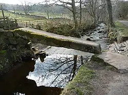 |
| Clapper Bridge | Wycoller, Trawden Forest | Bridge | Undateable | 23 April 1952 | SD9323739198 53°50′56″N 2°06′15″W / 53.848973°N 2.104282°W | 1243829 |  |
| Grain kiln with stable to rear of no. 39 | Winewall, Trawden Forest | Corn drying kiln | c. 1700 | 25 February 1970 | SD9121639969 53°51′21″N 2°08′06″W / 53.855872°N 2.135024°W | 1243705 |  |
| Pack Horse Bridge | Wycoller, Trawden Forest | Packhorse bridge | 17th century or earlier | 23 April 1952 | SD9323439248 53°50′58″N 2°06′16″W / 53.849423°N 2.104329°W | 1243828 | 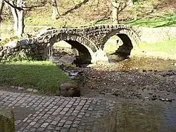 |
| Pierson's Farmhouse | Trawden Forest | Farmhouse | Late 17th century | 23 April 1952 | SD9318639271 53°50′59″N 2°06′18″W / 53.849629°N 2.105059°W | 1073327 |  |
| Remains of Wycoller Hall, including boundary wall to river | Trawden Forest | House | 1596 | 23 April 1952 | SD9327039207 53°50′57″N 2°06′14″W / 53.849055°N 2.103781°W | 1073331 |  |
Preston


.jpg)

.jpg)


Ribble Valley
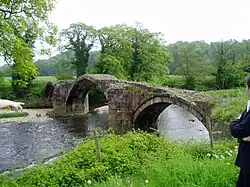
_-_geograph.org.uk_-_115680.jpg)


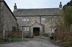
.jpg)

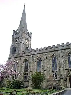
.jpg)


Rossendale


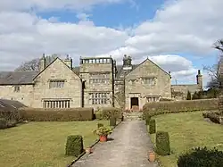
_-_geograph.org.uk_-_462467.jpg)


South Ribble


West Lancashire


Wyre


See also
- Category:Grade II* listed buildings in Lancashire
- Scheduled monuments in Lancashire
Notes
- ^ a b c d e f g h i j k l m n The date given is the date used by Historic England as significant for the initial building or that of an important part in the structure's description.
- ^ a b c d e f g h i j k l m n Sometimes known as OSGB36, the grid reference is based on the British national grid reference system used by the Ordnance Survey.
- ^ a b c d e f g h i j k l m n The "List Entry Number" is a unique number assigned to each listed building and scheduled monument by Historic England.
References
National Heritage List for England
External links
![]() Media related to Grade II* listed buildings in Lancashire at Wikimedia Commons
Media related to Grade II* listed buildings in Lancashire at Wikimedia Commons