Hoornsterzwaag
Hoornsterzwaag Hoarnstersweach | |
|---|---|
Village | |
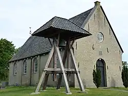 Hoornsterzwaag church and bell tower | |
 Location in the Heerenveen municipality | |
 Hoornsterzwaag Location in the Netherlands  Hoornsterzwaag Hoornsterzwaag (Netherlands) | |
| Coordinates: 52°59′54″N 6°10′21″E / 52.99833°N 6.17250°E | |
| Country | |
| Province | |
| Municipality | |
| Area | |
• Total | 19.90 km2 (7.68 sq mi) |
| Elevation | 4 m (13 ft) |
| Population (2021)[1] | |
• Total | 810 |
| • Density | 41/km2 (110/sq mi) |
| Postal code | 8412[1] |
| Dialing code | 0513 |
Hoornsterzwaag (West Frisian: Hoarnstersweach) is a small village in Heerenveen in the province of Friesland, the Netherlands. It had a population of around 830 in January 2017.[3]
History
The village was first mentioned in 1408 as Suage, and means "cattle field belonging to Oudehorne".[4] The church dates from 1621 and was extensively restored in 1856. The current bell tower dates from 2007. In 1840, Hoornsterzwaag was home to 151 people.[5]
Before 1934, Hoornsterzwaag was part of the Schoterland municipality.[5]
Gallery
-
 Little house in Hoornsterzwaag
 -
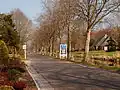 End of Jubbega, start of Hoornsterzwaag
 -
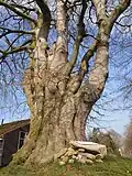 The poppebeam van Jobbega
References
- ^ a b c "Kerncijfers wijken en buurten 2021". Central Bureau of Statistics. Retrieved 30 March 2022.
- ^ "Postcodetool for 8412CA". Actueel Hoogtebestand Nederland (in Dutch). Het Waterschapshuis. Archived from the original on 21 September 2013. Retrieved 30 March 2022.
- ^ Kerncijfers wijken en buurten 2017 - CBS Statline
- ^ "Hoornsterzwaag - (geografische naam)". Etymologiebank (in Dutch). Retrieved 30 March 2022.
- ^ a b "Hoornsterzwaag". Plaatsengids (in Dutch). Retrieved 30 March 2022.
External links
![]() Media related to Hoornsterzwaag at Wikimedia Commons
Media related to Hoornsterzwaag at Wikimedia Commons