Jõelähtme (river)
| Jõelähtme River Raasiku jõgi, Jõelehtme jõgi | |
|---|---|
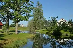 The Jõelähtme River at Kiviloo | |
| Native name | Jõelähtme jõgi (Estonian) |
| Physical characteristics | |
| Source | |
| • location | Rasivere (Anija Parish) |
| • coordinates | 59°11′59″N 25°20′11″E / 59.19984497827661°N 25.33646285533905°E |
| Mouth | |
• location | Jõelähtme Parish, flows into Jägala River |
• coordinates | 59°27′01″N 25°10′26″E / 59.450277962843735°N 25.173819065093994°E |
| Length | 49.2 km (30.6 mi) |
The Jõelähtme River (Estonian: Raasiku jõgi or Jõelehtme jõgi) is an Estonian river in Harju County.[1] The river starts in Rasivere (Anija Parish) and discharges into the Jägala River in Jõelähtme Parish, only 100 m (330 ft) after Jägala Falls. The length of the river is 49.2 km.[1]
The Jõelähtme River is one of the most significant subterranean rivers in Estonia; it flows underground through the Kostivere karst area for 2.5 km.[2]
References
- ^ a b "EELIS Infoleht". eelis.ee. Retrieved 20 January 2022.
- ^ "Ask a Researcher". tlu.ee. Retrieved 4 November 2022.