Latulipe-et-Gaboury
Latulipe-et-Gaboury | |
|---|---|
 Latulipe | |
 Location within Témiscamingue RCM | |
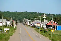
 Latulipe-et-Gaboury Location in western Quebec | |
| Coordinates: 47°25′38″N 79°01′56″W / 47.42722°N 79.03222°W[1] | |
| Country | Canada |
| Province | Quebec |
| Region | Abitibi-Témiscamingue |
| RCM | Témiscamingue |
| Settled | 1909 |
| Constituted | November 18, 1924 |
| Named after | Élie-Anicet Latulipe, Tancrède-Charles Gaboury[1] |
| Government | |
| • Mayor | Vincent Gingras |
| • Federal riding | Abitibi—Témiscamingue |
| • Prov. riding | Rouyn-Noranda–Témiscamingue |
| Area | |
• Total | 300.00 km2 (115.83 sq mi) |
| • Land | 270.11 km2 (104.29 sq mi) |
| Population (2021)[4] | |
• Total | 320 |
| • Density | 1.2/km2 (3/sq mi) |
| • Pop (2016–21) | |
| • Dwellings | 225 |
| Time zone | UTC−05:00 (EST) |
| • Summer (DST) | UTC−04:00 (EDT) |
| Postal code(s) | |
| Area code | 819 |
| Highways | |
| Website | www |
Latulipe-et-Gaboury (French pronunciation: [latylip e ɡabuʁi]) is a united township municipality in northwestern Quebec, Canada, in the Témiscamingue Regional County Municipality. The only other remaining united township municipality in Quebec is Stoneham-et-Tewkesbury.
The only population centre in the united township is the village of Latulipe.[5]
History
In 1909, the geographic township of Latulipe was proclaimed, named after Élie-Anicet Latulipe (1859-1922), first bishop of Haileybury. That same year, the first settlers arrived. And in 1919, the geographic township of Gaboury was proclaimed, named after Tancrède-Charles Gaboury (1851-1937). In November 1924, the United Township Municipality of Latulipe-et-Gaboury was established.[1]
Geography
Climate
| Climate data for Latulipe-et-Gaboury | |||||||||||||
|---|---|---|---|---|---|---|---|---|---|---|---|---|---|
| Month | Jan | Feb | Mar | Apr | May | Jun | Jul | Aug | Sep | Oct | Nov | Dec | Year |
| Record high °C (°F) | 13.3 (55.9) | 13.5 (56.3) | 21.1 (70.0) | 31.7 (89.1) | 34.4 (93.9) | 38.9 (102.0) | 39.4 (102.9) | 38.9 (102.0) | 32.8 (91.0) | 30 (86) | 21.1 (70.0) | 17.2 (63.0) | 39.4 (102.9) |
| Mean daily maximum °C (°F) | −9.5 (14.9) | −6.9 (19.6) | −0.5 (31.1) | 7.9 (46.2) | 16.2 (61.2) | 21.4 (70.5) | 24.2 (75.6) | 22.5 (72.5) | 16.7 (62.1) | 9.9 (49.8) | 1.4 (34.5) | −5.9 (21.4) | 8.1 (46.6) |
| Daily mean °C (°F) | −15 (5) | −12.7 (9.1) | −6.2 (20.8) | 2.5 (36.5) | 10.4 (50.7) | 15.7 (60.3) | 18.8 (65.8) | 17.4 (63.3) | 12.2 (54.0) | 6 (43) | −1.9 (28.6) | −10.4 (13.3) | 3.1 (37.6) |
| Mean daily minimum °C (°F) | −20.5 (−4.9) | −18.5 (−1.3) | −11.9 (10.6) | −2.9 (26.8) | 4.4 (39.9) | 10 (50) | 13.3 (55.9) | 12.3 (54.1) | 7.6 (45.7) | 2.1 (35.8) | −5.3 (22.5) | −14.9 (5.2) | −2 (28) |
| Record low °C (°F) | −43 (−45) | −43 (−45) | −37.8 (−36.0) | −24 (−11) | −10 (14) | −2.2 (28.0) | 2 (36) | −1.7 (28.9) | −6.1 (21.0) | −13.3 (8.1) | −27.8 (−18.0) | −42.8 (−45.0) | −43 (−45) |
| Average precipitation mm (inches) | 61 (2.4) | 45.7 (1.80) | 57.1 (2.25) | 74.6 (2.94) | 89.4 (3.52) | 88.6 (3.49) | 94.9 (3.74) | 106.6 (4.20) | 93.6 (3.69) | 99.9 (3.93) | 83.5 (3.29) | 72 (2.8) | 966.9 (38.07) |
| Source: Environment Canada[6] | |||||||||||||
Demographics
In the 2021 Census of Population conducted by Statistics Canada, Latulipe-et-Gaboury had a population of 320 living in 159 of its 225 total private dwellings, a change of 8.5% from its 2016 population of 295. With a land area of 270.11 km2 (104.29 sq mi), it had a population density of 1.2/km2 (3.1/sq mi) in 2021.[4]
|
|
| ||||||||||||||||||||||||||||||||||||||||||||||||||||||||||||
| Population counts are not adjusted for boundary changes. Source: Statistics Canada[4][7] | ||||||||||||||||||||||||||||||||||||||||||||||||||||||||||||||
Mother tongue (2021):[4]
- English as first language: 1.6%
- French as first language: 98.4%
- English and French as first language: 0%
- Other as first language: 0%
Sister cities
- Brocas les Forges (France)[8]
See also
References
- ^ a b c "Banque de noms de lieux du Québec: Reference number 34616". toponymie.gouv.qc.ca (in French). Commission de toponymie du Québec.
- ^ a b "Répertoire des municipalités: Geographic code 85060". www.mamh.gouv.qc.ca (in French). Ministère des Affaires municipales et de l'Habitation. Retrieved 2023-12-12.
- ^ Tanya Neveu (20 December 2021). "Latulipe-et-Gaboury pourvoit son poste de maire". ICI.Radio-Canada.ca (in French). Radio-Canada. Retrieved 12 December 2023.
- ^ a b c d e "Latulipe-et-Gaboury census profile". 2021 Census data. Statistics Canada. Retrieved 2022-05-05.
- ^ "Banque de noms de lieux du Québec: Latulipe (village)". toponymie.gouv.qc.ca (in French). Commission de toponymie du Québec. Retrieved 2023-12-12.
- ^ Environment Canada, Based from the Laverlochère-Angliers Weather Station https://climate.weather.gc.ca/climate_normals/results_1981_2010_e.html?searchType=stnProx&txtRadius=200&selCity=&selPark=&optProxType=custom&txtCentralLatDeg=47&txtCentralLatMin=25&txtCentralLatSec=38&txtCentralLongDeg=79&txtCentralLongMin=01&txtCentralLongSec=56&txtLatDecDeg=&txtLongDecDeg=&stnID=5976&dispBack=0 Canadian Climate Normals 1981–2010], accessed 6 March 2025
- ^ 1996, 2001, 2006, 2011, 2016 census
- ^ "Municipalite". latulipeetgaboury.net (in French). Municipalité de cantons unis de Latulipe-et-Gaboury. 2023. Retrieved 11 December 2023.
External links
Adjacent Municipal Subdivisions | ||||||||||||||||
|---|---|---|---|---|---|---|---|---|---|---|---|---|---|---|---|---|
| ||||||||||||||||
| Cities | |
|---|---|
| Municipalities | |
| Townships | |
| Parishes | |
| United townships | |
| Unorganized territories | |
| |