Les Infournas
Les Infournas | |
|---|---|
Part of Saint-Bonnet-en-Champsaur | |
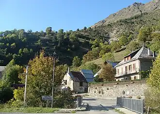 The hamlet of Infournas-hauts, seen from the access road | |
Location of Les Infournas | |
 Les Infournas  Les Infournas | |
| Coordinates: 44°42′57″N 6°05′40″E / 44.7158°N 6.0944°E | |
| Country | France |
| Region | Provence-Alpes-Côte d'Azur |
| Department | Hautes-Alpes |
| Arrondissement | Gap |
| Canton | Saint-Bonnet-en-Champsaur |
| Commune | Saint-Bonnet-en-Champsaur |
Area 1 | 8.69 km2 (3.36 sq mi) |
| Population (2021)[1] | 29 |
| • Density | 3.3/km2 (8.6/sq mi) |
| Time zone | UTC+01:00 (CET) |
| • Summer (DST) | UTC+02:00 (CEST) |
| Postal code | 05500 |
| Elevation | 1,158–2,442 m (3,799–8,012 ft) (avg. 1,235 m or 4,052 ft) |
| 1 French Land Register data, which excludes lakes, ponds, glaciers > 1 km2 (0.386 sq mi or 247 acres) and river estuaries. | |
Les Infournas (Vivaro-Alpine: Infornats) is a former commune in the Hautes-Alpes department in southeastern France. Since 2013 it is part of the commune Saint-Bonnet-en-Champsaur.
Population
| Year | Pop. | ±% |
|---|---|---|
| 1962 | 53 | — |
| 1968 | 56 | +5.7% |
| 1975 | 43 | −23.2% |
| 1982 | 36 | −16.3% |
| 1990 | 29 | −19.4% |
| 1999 | 24 | −17.2% |
| 2008 | 26 | +8.3% |
See also
References
- ^ "Populations légales 2021" [Legal populations 2021] (PDF) (in French). INSEE. December 2023.
Wikimedia Commons has media related to Les Infournas.