| River order | Name | Image | From /To
Coordinates | Carries | Date | Heritage
status | Notes & refs |
| 1 | Footbridge | .jpg) | Sharnford
52°31′27″N 1°16′55″W / 52.52412°N 1.28196°W / 52.52412; -1.28196 (Footbridge) | Footpath | | | Footbridge downstream of Soar Brook confluence. |
| 2 | Road Bridge |  | Sapcote
52°31′29″N 1°16′50″W / 52.52461°N 1.28064°W / 52.52461; -1.28064 (Road Bridge) | Main Street | | | Road to Frolesworth. |
| 3 | Stoney Bridge | .jpg) | Sapcote
52°31′56″N 1°15′33″W / 52.53219°N 1.25908°W / 52.53219; -1.25908 (Stoney Bridge) | Fosse Way | | | First named bridge. |
| 4 | Road Bridge |  | Broughton Astley
52°32′25″N 1°14′53″W / 52.54030°N 1.24810°W / 52.54030; -1.24810 (Road Bridge) | B581 | | | Coventry Road. |
| 5 | Sutton Hill Bridge | | Broughton Astley
52°32′31″N 1°14′52″W / 52.54199°N 1.24790°W / 52.54199; -1.24790 (Sutton Hill Bridge) | B4114 | | | Coventry Road. |
| 6 | Sopers Bridge & Footbridge | 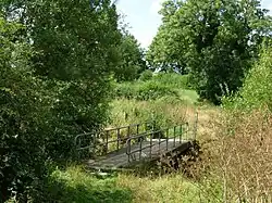 | Croft
52°32′52″N 1°15′27″W / 52.54778°N 1.25741°W / 52.54778; -1.25741 (Sopers Bridge & Footbridge) | Footpath | | II | Sopers Bridge is located on an old course of the river.[8] |
| 7 | Railway bridge | | Croft
52°33′24″N 1°15′03″W / 52.55671°N 1.25097°W / 52.55671; -1.25097 (Railway bridge) | Birmingham to Peterborough Line | | | Stoney Stanton to Croft. |
| 8 | Croft Bridge | 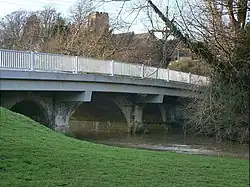 | Croft
52°33′31″N 1°14′49″W / 52.55864°N 1.24698°W / 52.55864; -1.24698 (Croft Bridge) | Station Road | | | Modern road bridge. |
| 9 | Footbridge | 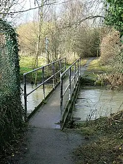 | Croft
52°33′30″N 1°14′31″W / 52.55835°N 1.24202°W / 52.55835; -1.24202 (Footbridge) | Footpath | | | Near Croft Quarry. |
| 10 | Langham Bridge | .jpg) | Narborough
52°34′06″N 1°13′00″W / 52.56825°N 1.21669°W / 52.56825; -1.21669 (Langham Bridge) | Coventry Road | | | Historic bridging point of Fosse Way. |
| 11 | Railway bridge | | Narborough
52°34′05″N 1°12′42″W / 52.56800°N 1.21168°W / 52.56800; -1.21168 (Railway bridge) | Birmingham to Peterborough Line | | | Upstream from Narborough station. |
| 12 | Station Road Bridge | .jpg) | Littlethorpe
52°34′15″N 1°12′12″W / 52.57081°N 1.20342°W / 52.57081; -1.20342 (Station Road Bridge) | Station Road | | | Near Narborough Station. |
| 13 | M1 Bridge |  | Narborough
52°34′17″N 1°11′36″W / 52.57136°N 1.19342°W / 52.57136; -1.19342 (M1 Bridge) | M1 Motorway | | | Motorway bridge. |
| 14 | Railway bridge | | Enderby
52°34′33″N 1°11′19″W / 52.57592°N 1.18856°W / 52.57592; -1.18856 (Railway bridge) | Birmingham to Peterborough Line | | | Downstream of M1. |
| 15 | Enderby Mill Bridge | .jpg) | Enderby
52°34′50″N 1°11′23″W / 52.58069°N 1.18962°W / 52.58069; -1.18962 (Enderby Mill Bridge) | Footpath | 15th century | SM | Scheduled bridge with adjacent footbridge.[11] |
| 16 | Enderby Bridge | .jpg) | Enderby
52°34′53″N 1°11′19″W / 52.58145°N 1.18858°W / 52.58145; -1.18858 (Enderby Bridge) | Enderby Rd | | | Modern road bridge. |
| 17 | Soar Valley Way | 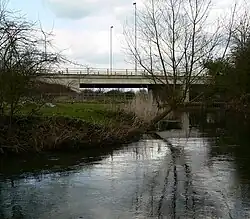 | Enderby
52°35′45″N 1°10′12″W / 52.59594°N 1.17007°W / 52.59594; -1.17007 (Soar Valley Way) | A563 | | | Dual carriageway. |
| 18 | Aylestone Packhorse Bridge |  | Aylestone
52°36′12″N 1°09′46″W / 52.60326°N 1.16288°W / 52.60326; -1.16288 (Aylestone Packhorse Bridge) | Footpath | 15th century | II & SM | Scheduled packhorse bridge.[13] |
| 19 | Footbridge | .jpg) | Aylestone
52°36′12″N 1°09′44″W / 52.60338°N 1.16229°W / 52.60338; -1.16229 (Footbridge) | Towpath | | | Crosses Soar where it joins with canal. |
| 20 | Footbridge |  | Aylestone
52°36′14″N 1°09′40″W / 52.60383°N 1.16117°W / 52.60383; -1.16117 (Footbridge) | Grand Central Way | | | Former Great Central Railway. |
| 21 | Freestone Bridge |  | Aylestone
52°36′17″N 1°09′34″W / 52.60466°N 1.15944°W / 52.60466; -1.15944 (Freestone Bridge) | Braunstone Lane East | | | Braunstone Lane East. |
| 22 | Parsons Bridge | 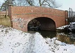 | Aylestone
52°36′25″N 1°09′13″W / 52.60698°N 1.15359°W / 52.60698; -1.15359 (Parsons Bridge) | Canal Street | | | Access road to Aylestone Meadows. |
| 23 | Aylestone Mill | .jpg) | Aylestone
52°36′36″N 1°08′47″W / 52.60995°N 1.14646°W / 52.60995; -1.14646 (Aylestone Mill) | Aylestone Mill | | | Access road to Aylestone Meadows. |
| 24 | Access bridge | .jpg) | Aylestone
52°36′40″N 1°08′36″W / 52.61101°N 1.14346°W / 52.61101; -1.14346 (Access bridge) | Access road | | | Access road to industrial estate. |
| 25 | Twelve Arches railway viaduct |  | Westcotes
52°37′12″N 1°08′48″W / 52.61987°N 1.14656°W / 52.61987; -1.14656 (Twelve Arches railway viaduct) | Leicester–Burton upon Trent line | | | Upstream of Freemans Weir. |
| 26 | Footbridge across Old Soar | .jpg) | Bede Island
52°37′28″N 1°08′37″W / 52.62435°N 1.14354°W / 52.62435; -1.14354 (Footbridge across Old Soar) | Towpath | | | Old River Soar - first crossing. |
| 27 | Watkin Road Bridge | .jpg) | Bede Island
52°37′31″N 1°08′41″W / 52.62534°N 1.14485°W / 52.62534; -1.14485 (Watkin Road Bridge) | Access road | | | Old River Soar. |
| 28 | Upperton Road Bridge | .jpg) | Bede Island
52°37′33″N 1°08′43″W / 52.62572°N 1.14532°W / 52.62572; -1.14532 (Upperton Road Bridge) | Upperton Road | | | Old River Soar. |
| 29 | Great Central Way footbridge | .jpg) | Bede Island
52°37′36″N 1°08′47″W / 52.62661°N 1.14641°W / 52.62661; -1.14641 (Great Central Way footbridge) | Great Central Way | | | Former railway bridge over the Old River Soar - a disused bridge is adjacent. |
| 30 | Footbridge | | Bede Island
52°37′41″N 1°08′47″W / 52.62816°N 1.14639°W / 52.62816; -1.14639 (Footbridge) | Footpath | | | Old Soar - Modern Footbridge. |
| 31 | Western Boulevard | .jpg) | Bede Island
52°37′55″N 1°08′39″W / 52.63194°N 1.14426°W / 52.63194; -1.14426 (Western Boulevard) | Road | | | Old Soar, site of demolished Braunstone Gate Bridge. |
| 32 | Bow Bridge | .jpg) | Bede Island
52°38′02″N 1°08′39″W / 52.63397°N 1.14425°W / 52.63397; -1.14425 (Bow Bridge) | A47 | 1863 | | Old Soar-St Augustine Road bridge. |
| 33 | Upperton Road Bridge | .jpg) | Mile Straight
52°37′32″N 1°08′35″W / 52.62562°N 1.14310°W / 52.62562; -1.14310 (Upperton Road Bridge) | Upperton Road | 1890 | II | One of four listed bridges on the Mile Straight.[17] |
| 34 | Swan Bridge | .jpg) | Mile Straight
52°37′34″N 1°08′35″W / 52.62604°N 1.14302°W / 52.62604; -1.14302 (Swan Bridge) | Upperton Road | | | 109A Eastbound Modern bridge. |
| 35 | Mill Lane bridge | .jpg) | Mile Straight
52°37′44″N 1°08′33″W / 52.62875°N 1.14260°W / 52.62875; -1.14260 (Mill Lane bridge) | Mill Lane | 1890 | II | One of four listed bridges on the Mile Straight.[18] |
| 36 | Newarke Bridge | .jpg) | Mile Straight
52°37′52″N 1°08′32″W / 52.63110°N 1.14226°W / 52.63110; -1.14226 (Newarke Bridge) | The Newarke | 1898 | II | One of four listed bridges on the Mile Straight.[19] |
| 37 | Footbridge | .jpg) | Mile Straight
52°37′57″N 1°08′31″W / 52.63262°N 1.14205°W / 52.63262; -1.14205 (Footbridge) | Footpath | | | Bridge 2A. |
| 38 | West Bridge | .jpg) | Mile Straight
52°38′01″N 1°08′32″W / 52.63362°N 1.14219°W / 52.63362; -1.14219 (West Bridge) | A47 | 1891 | II | Historic bridging point, one of four listed bridges on the Mile Straight.[20] |
| 39 | West Bridge | .jpg) | Mile Straight
52°38′02″N 1°08′33″W / 52.63380°N 1.14239°W / 52.63380; -1.14239 (West Bridge) | A47 | | | Eastbound Modern. |
| 40 | Footbridge |  | Westcotes
52°38′15″N 1°08′42″W / 52.63761°N 1.14498°W / 52.63761; -1.14498 (Footbridge) | Footpath | | | Evans Weir. |
| 41 | Soar Lane bridge | .jpg) | Westcotes
52°38′18″N 1°08′44″W / 52.63821°N 1.14546°W / 52.63821; -1.14546 (Soar Lane bridge) | Soar Lane | | | West side of Soar island. |
| 42 | Footbridge |  | Soar Island
52°38′23″N 1°08′44″W / 52.63979°N 1.14566°W / 52.63979; -1.14566 (Footbridge) | Towpath | | | Between Soar and Frog Island. |
| 43 | North Bridge | .jpg) | Frog Island
52°38′35″N 1°08′39″W / 52.64293°N 1.14414°W / 52.64293; -1.14414 (North Bridge) | A50 | | | Links Woodgate to Frog Island. |
| 44 | St Margarets Way | .jpg) | Frog Island
52°38′39″N 1°08′26″W / 52.64421°N 1.14053°W / 52.64421; -1.14053 (St Margarets Way) | A6 | | | Dual bridges. |
| 45 | Footbridge | .jpg) | Abbey Park
52°38′40″N 1°08′23″W / 52.64456°N 1.13973°W / 52.64456; -1.13973 (Footbridge) | Footpath | | | Concrete footbridge. |
| 46 | Abbey Park Bridge | .jpg) | Abbey Park
52°38′49″N 1°08′13″W / 52.64688°N 1.13685°W / 52.64688; -1.13685 (Abbey Park Bridge) | Footpath | | | Ornamental footbridge. |
| 47 | Abbey Corner Bridge |  | Abbey Park
52°38′57″N 1°08′03″W / 52.64904°N 1.13423°W / 52.64904; -1.13423 (Abbey Corner Bridge) | Abbey Park Road | 1878 | II | Abbey Park Road Bridge.[23] |
| 48 | Abbey Meadows footbridge | _(geograph_3757586).jpg) | Abbey Meadows
52°39′10″N 1°07′57″W / 52.65265°N 1.13237°W / 52.65265; -1.13237 (Abbey Meadows footbridge) | Footpath | 2013 | | Wolsey Point to National Space Centre |
| 49 | Holden Street footbridge | .jpg) | Belgrave
52°39′20″N 1°07′32″W / 52.65551°N 1.12563°W / 52.65551; -1.12563 (Holden Street footbridge) | Footpath | 1985 | | Refurbished in 2015. |
| 50 | Belgrave Bridge | 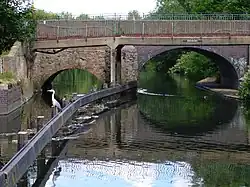 | Belgrave
52°39′39″N 1°07′42″W / 52.66082°N 1.12833°W / 52.66082; -1.12833 (Belgrave Bridge) | Thurcaston Road | Probable 15th century | II | Thurcaston Road Bridge (Old Bridge).[24] |
| 51 | New Bridge | 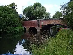 | Belgrave
52°39′47″N 1°07′37″W / 52.66297°N 1.12685°W / 52.66297; -1.12685 (New Bridge) | Loughborough Road | 1834 | II | Loughborough Road Bridge.[25] |
| 52 | Watermead Bridge |  | Rushey Mead
52°40′00″N 1°07′06″W / 52.66664°N 1.11827°W / 52.66664; -1.11827 (Watermead Bridge) | Watermead Way | | | A563. |
| 53 | Birstall weir footbridge | .jpg) | Rushey Mead
52°40′20″N 1°06′51″W / 52.67210°N 1.11430°W / 52.67210; -1.11430 (Birstall weir footbridge) | Towpath | | | Curved weir and footbridge. |
| 54 | Footbridge | | Birstall
52°40′22″N 1°06′50″W / 52.67265°N 1.11380°W / 52.67265; -1.11380 (Footbridge) | Footpath | | | Near Birstall Lock. |
| 55 | Birstall Lock footbridge | .jpg) | Birstall
52°40′26″N 1°06′58″W / 52.67378°N 1.11620°W / 52.67378; -1.11620 (Birstall Lock footbridge) | Footpath | | | One of a number of bridges at Birstall Lock. |
| 56 | Birstall Lock footbridge | .jpg) | Birstall
52°40′26″N 1°06′57″W / 52.67381°N 1.11596°W / 52.67381; -1.11596 (Birstall Lock footbridge) | Footpath | | | Bridge 14c. |
| 57 | Footbridge | .jpg) | Birstall
52°40′29″N 1°07′01″W / 52.67459°N 1.11690°W / 52.67459; -1.11690 (Footbridge) | Towpath | | | White Horse Lane. |
| 58 | Footbridge | .jpg) | Watermead Country Park
52°40′43″N 1°06′09″W / 52.67865°N 1.10240°W / 52.67865; -1.10240 (Footbridge) | Towpath | | | Bridge 16B, Thurmaston Weir. |
| 59 | Footbridge | .jpg) | Watermead Country Park
52°40′47″N 1°06′07″W / 52.67968°N 1.10195°W / 52.67968; -1.10195 (Footbridge) | Towpath | | | Downstream of Thurmaston Lock. |
| 60 | Footbridge | .jpg) | Watermead Country Park
52°41′01″N 1°06′04″W / 52.68362°N 1.10116°W / 52.68362; -1.10116 (Footbridge) | Towpath | | | Crosses Soar where it splits with canal. |
| 61 | Footbridge |  | Watermead Country Park
52°41′08″N 1°06′21″W / 52.68564°N 1.10588°W / 52.68564; -1.10588 (Footbridge) | Footpath | | | King Lears Lake. |
| 62 | Pochin Bridge |  | Wanlip
52°41′48″N 1°06′30″W / 52.69668°N 1.10837°W / 52.69668; -1.10837 (Pochin Bridge) | A46 | | | Leicester Western Bypass. |
| 63 | Cossington footbridge | .jpg) | Cossington
52°42′34″N 1°07′12″W / 52.70954°N 1.12005°W / 52.70954; -1.12005 (Cossington footbridge) | Towpath | | | Above Cossington Lock.[2] |
| 64 | Cossington Bridge | 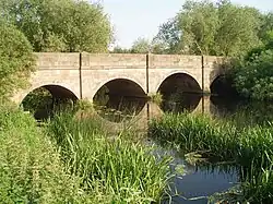 | Cossington
52°42′41″N 1°07′15″W / 52.71130°N 1.12090°W / 52.71130; -1.12090 (Cossington Bridge) | Cossington Lane | c. 1800 | II | Listed bridge.[29] |
| 65 | Sileby Lock footbridges | .jpg) | Sileby
52°43′38″N 1°07′26″W / 52.72724°N 1.12400°W / 52.72724; -1.12400 (Sileby Lock footbridges) | Towpath | | | Series of three footbridges.[2] |
| 66 | Sileby Mill footbridge | 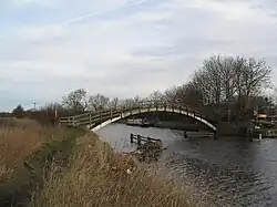 | Sileby
52°43′42″N 1°07′32″W / 52.72832°N 1.12547°W / 52.72832; -1.12547 (Sileby Mill footbridge) | Towpath | | | Sileby Mill.[2] |
| 67 | A6 bridge | .jpg) | Mountsorrel
52°43′56″N 1°08′04″W / 52.73220°N 1.13450°W / 52.73220; -1.13450 (A6 bridge) | A6 | | | One of four A6 crossings.[2] |
| 68 | Sileby Lane bridge | .jpg) | Mountsorrel
52°43′52″N 1°08′25″W / 52.73119°N 1.14021°W / 52.73119; -1.14021 (Sileby Lane bridge) | Sileby Lane | | | East of Mountsorrel.[2] |
| 69 | Mountsorrel mineral railway bridge | .jpg) | Mountsorrel
52°43′59″N 1°08′35″W / 52.73294°N 1.14292°W / 52.73294; -1.14292 (Mountsorrel mineral railway bridge) | Conveyor | 1860 | II | 1860 bridge - Brick bridge.[5] |
| 70 | Mountsorrel turnover Bridge 26 |  | Mountsorrel
52°44′07″N 1°08′40″W / 52.73541°N 1.14451°W / 52.73541; -1.14451 (Mountsorrel turnover Bridge 26) | Towpath | | | Carries towpath from one bank to the other.[2] |
| 71 | A6 bridge | 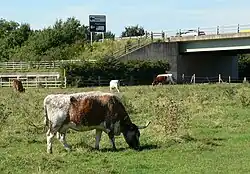 | Mountsorrel
52°44′22″N 1°08′33″W / 52.73934°N 1.14263°W / 52.73934; -1.14263 (A6 bridge) | A6 | | | One of four A6 crossings.[2] |
| 72 | Footbridge | .jpg) | Barrow upon Soar
52°44′45″N 1°08′40″W / 52.74573°N 1.14457°W / 52.74573; -1.14457 (Footbridge) | Towpath | | | Crosses over weir.[2] |
| 73 | Footbridge | | Barrow upon Soar
52°44′37″N 1°08′47″W / 52.74367°N 1.14652°W / 52.74367; -1.14652 (Footbridge) | Footpath | | | Between Barrow and A6.[2] |
| 74 | A6 bridge | .jpg) | Barrow upon Soar
52°44′33″N 1°08′52″W / 52.74240°N 1.14790°W / 52.74240; -1.14790 (A6 bridge) | A6 | | | One of four A6 crossings.[2] |
| 75 | A6 bridge | | Quorn
52°44′54″N 1°09′31″W / 52.74830°N 1.15861°W / 52.74830; -1.15861 (A6 bridge) | A6 | | | One of four A6 crossings.[2] |
| 76 | Mill Lane bridge | 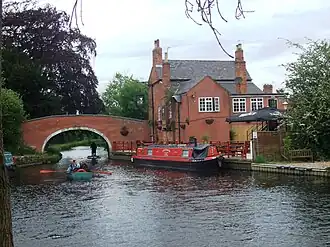 | Barrow upon Soar
52°44′45″N 1°08′50″W / 52.74590°N 1.14733°W / 52.74590; -1.14733 (Mill Lane bridge) | Mill Lane | | | Navigation Inn.[2] |
| 77 | Barrow Lock bdg | 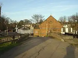 | Barrow upon Soar
52°44′59″N 1°09′10″W / 52.74981°N 1.15265°W / 52.74981; -1.15265 (Barrow Lock bdg) | Proctors Park Road | | | Minor road.[2] |
| 78 | Barrow Road Bridge | 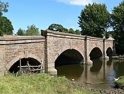 | Barrow upon Soar
52°45′03″N 1°09′11″W / 52.75081°N 1.15303°W / 52.75081; -1.15303 (Barrow Road Bridge) | Bridge Street | 1845 | II | Listed bridge.[30] |
| 79 | Pillings Lock rail bdg |  | Barrow upon Soar
52°45′35″N 1°09′49″W / 52.75970°N 1.16350°W / 52.75970; -1.16350 (Pillings Lock rail bdg) | Midland Main Line | | | Railway bridge.[2] |
| 80 | Cotes Bridge | 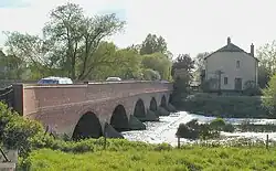 | Cotes
52°46′49″N 1°10′49″W / 52.78026°N 1.18025°W / 52.78026; -1.18025 (Cotes Bridge) | A60 | 18th century | II | Nottingham Road.[31] |
| 81 | Footbridge |  | Cotes
52°47′22″N 1°11′41″W / 52.78939°N 1.19466°W / 52.78939; -1.19466 (Footbridge) | Footpath | | | One of two footbridges at this point.[2] |
| 82 | Footbridge |  | Cotes
52°47′19″N 1°11′43″W / 52.78857°N 1.19518°W / 52.78857; -1.19518 (Footbridge) | Footpath | | | One of two footbridges at this point.[2] |
| 83 | Stanford Viaduct |  | Stanford on Soar
52°47′25″N 1°11′51″W / 52.79030°N 1.19740°W / 52.79030; -1.19740 (Stanford Viaduct) | Great Central Railway (heritage railway) | 1899 | | Skewed central arches.[2] |
| 84 | Meadow Lane Bridge | .jpg) | Stanford on Soar
52°47′26″N 1°11′55″W / 52.79063°N 1.19849°W / 52.79063; -1.19849 (Meadow Lane Bridge) | Meadow Lane | | | Minor road.[2] |
| 85 | Railway bridge | .jpg) | Stanford on Soar
52°47′37″N 1°12′59″W / 52.79370°N 1.21650°W / 52.79370; -1.21650 (Railway bridge) | Midland Main Line | | | Major rail bridge.[2] |
| 86 | Zouch footbridges |  | Zouch
52°48′22″N 1°14′45″W / 52.80618°N 1.24575°W / 52.80618; -1.24575 (Zouch footbridges) | Footpath | | | A series of three footbridges over the weirs at Zouch.[2] |
| 87 | Zouch Bridge | .jpg) | Zouch
52°48′16″N 1°15′22″W / 52.80448°N 1.25606°W / 52.80448; -1.25606 (Zouch Bridge) | A6006 | | | County Bridge, due for replacement.[2] |
| 88 | Kegworth Bridge |  | Kegworth
52°50′25″N 1°16′09″W / 52.84034°N 1.26906°W / 52.84034; -1.26906 (Kegworth Bridge) | Station Road | 1785 | II | Grade II bridge, widened in 1937.[32] |
| 89 | Kegworth footbridge |  | Kegworth
52°50′31″N 1°16′01″W / 52.84183°N 1.26706°W / 52.84183; -1.26706 (Kegworth footbridge) | Towpath | | | Carries towpath across the river.[2] |
| 90 | A453 Bridge |  | Ratcliffe-on-Soar
52°51′28″N 1°15′53″W / 52.85784°N 1.26459°W / 52.85784; -1.26459 (A453 Bridge) | A453 | | | Remembrance Way.[2] |
| 91 | Ratcliffe on Soar Ford | .jpg) | Ratcliffe-on-Soar
52°51′33″N 1°15′55″W / 52.85903°N 1.26538°W / 52.85903; -1.26538 (Ratcliffe on Soar Ford) | Bridleway | | | Ford across the Soar.[2] |
| 92 | Soar Mouth |  | Ratcliffe-on-Soar
52°52′23″N 1°16′06″W / 52.87313°N 1.26829°W / 52.87313; -1.26829 (Soar Mouth) | Trent Lock ferry | | | In the 1900s a ferry crossed from the Soar to Trent Lock at the Trent confluence, carrying horses and passengers.[33][2] |
.jpg)