The Irish state has officially approved the following list of national monuments in County Wicklow. In the Republic of Ireland, a structure or site may be deemed to be a "national monument", and therefore worthy of state protection, if it is of national importance. If the land adjoining the monument is essential to protect it, this land may also be protected.
National Monuments
| NM# | Monument name | Description | Image | Townland | Location |
| 137 | Aghowle Church | Church & Cross | 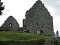 | Aghowle Lower (Shillelagh | 52°46′04″N 6°37′13″W / 52.767899°N 6.620402°W / 52.767899; -6.620402 (Aghowle Church) |
| 416 | Piper's Stones | Stone Circle |  | Athgreany | 53°04′19″N 6°36′46″W / 53.071899°N 6.612791°W / 53.071899; -6.612791 (Piper's Stones) |
| 203 | Baltinglass Abbey | Abbey (Cistercian) |  | Baltinglass | 52°56′38″N 6°42′35″W / 52.943886°N 6.709747°W / 52.943886; -6.709747 (Baltinglass Abbey) |
| 418 | Crossoona Rath | Ringfort & Ogham Stone | | Boleycarrigeen | 52°56′39″N 6°36′51″W / 52.944262°N 6.614062°W / 52.944262; -6.614062 (Crossoona Rath) |
| 134 | Glendalough | Cathedral, Round Tower, Churches, Priory (Augustinian), Crosses, ringfort, hut site & cave |  | Glendalough | 53°00′37″N 6°19′39″W / 53.010278°N 6.3275°W / 53.010278; -6.3275 (Glendalough) |
| 280 | St. Mark's Cross | High Cross | 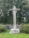 | Burgage More | 53°09′41″N 6°32′29″W / 53.161499°N 6.54141°W / 53.161499; -6.54141 (St. Mark's Cross) |
| 442 | Castleruddery Motte | Motte | | Castleruddery Lower | 52°59′34″N 6°38′40″W / 52.992817°N 6.644379°W / 52.992817; -6.644379 (Castleruddery Motte) |
| 441 | Castleruddery Stone Circle | Stone Circle | 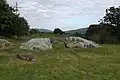 | Castleruddery Lower | 52°59′28″N 6°38′12″W / 52.991092°N 6.636715°W / 52.991092; -6.636715 (Castleruddery Stone Circle) |
| 304 | Castletimon Ogham Stone | Ogham Stone | | Castletimon | 52°54′16″N 6°04′13″W / 52.904307°N 6.070199°W / 52.904307; -6.070199 (Castletimon Ogham Stone) |
| 662 | Rath Turtle Moat | Ringfort |  | Deerpark | 53°10′46″N 6°33′28″W / 53.179395°N 6.557808°W / 53.179395; -6.557808 (Rath Turtle Moat) |
| 449 | Dwyer–McAllister Cottage | House with historical associations |  | Derrynamuck (Donard) | 52°57′44″N 6°33′53″W / 52.962126°N 6.564607°W / 52.962126; -6.564607 (Dwyer–McAllister Cottage) |
| 337 | Fassaroe Cross | Cross |  | Fassaroe, Bray | 53°11′46″N 6°08′26″W / 53.19598°N 6.14051°W / 53.19598; -6.14051 (Fassaroe Cross) |
| 267 | Kilcoole Church | Church |  | Kilcoole | 53°06′25″N 6°03′46″W / 53.10708°N 6.06278°W / 53.10708; -6.06278 (Kilcoole Church) |
| 417 | Kilcroney Church | Church |  | Kilcroney | 53°11′10″N 6°08′20″W / 53.186146°N 6.138794°W / 53.186146; -6.138794 (Kilcroney Church) |
| 323 | Kindlestown Castle | Castle |  | Kindlestown Upper | 53°08′28″N 6°05′20″W / 53.141190°N 6.089022°W / 53.141190; -6.089022 (Kindlestown Castle) |
| 419 | Lemonstown Motte | Motte |  | Lemonstown | 53°05′07″N 6°39′27″W / 53.085262°N 6.657435°W / 53.085262; -6.657435 (Lemonstown Motte) |
| 368 | Moylisha Wedge Tomb | Wedge Tomb |  | Moylisha | 52°45′05″N 6°37′20″W / 52.751400°N 6.622294°W / 52.751400; -6.622294 (Moylisha Wedge Tomb) |
| 262 | Raheenachluig Church | Church |  | Newcourt | 53°11′38″N 6°05′26″W / 53.19379°N 6.090503°W / 53.19379; -6.090503 (Raheenachluig Church) |
| 328 | Rathcoran | Passage Tomb & Hillfort | | Coolinarrig Upper, Pinnacle, Tuckmill Hill | 52°56′49″N 6°41′00″W / 52.946997°N 6.683220°W / 52.946997; -6.683220 (Rathcoran) |
| 422 | Rathgall | Hill Fort |  | Rath | 52°48′08″N 6°39′47″W / 52.80224°N 6.663131°W / 52.80224; -6.663131 (Rathgall) |
| 317 | Seefin Passage Tomb | Passage Tomb |  | Scurlocksleap | 53°11′10″N 6°23′42″W / 53.186168°N 6.394889°W / 53.186168; -6.394889 (Seefin Passage Tomb) |
| 491 | Threecastles Castle | Castle |  | Threecastles | 53°10′54″N 6°29′14″W / 53.181654°N 6.487324°W / 53.181654; -6.487324 (Threecastles Castle) |
| 531 | Tornant Moat | Ringfort & Barrows | | Tornant Lower | 53°02′43″N 6°42′04″W / 53.045350°N 6.701020°W / 53.045350; -6.701020 (Tornant Moat) |
| 135 | St. Mary's Church, Downsmill | Church (11th century) |  | Woodlands | 53°07′47″N 6°06′38″W / 53.129729°N 6.110652°W / 53.129729; -6.110652 (St. Mary's Church, Downsmill) |
Sources
