Listed buildings in Aylesford
Aylesford is village and a civil parish in the Tonbridge and Malling district of Kent, England. It contains 77 listed buildings that are recorded in the National Heritage List for England. Of these four are grade I, five are grade II* and 68 are grade II.
This list is based on the information retrieved online from Historic England.[1][2][3]
Listing
| Name | Grade | Location | Type | Completed [note 1] | Date designated | Grid ref.[note 2] Geo-coordinates | Entry number [note 3] | Image | Wikidata |
|---|---|---|---|---|---|---|---|---|---|
| Barn | II | Aylesford, Bull Lane, 50 Yards East of Court Lodge Farmhouse | Bartn | 25 February 1987 | TQ7237759074 51°18′17″N 0°28′17″E / 51.304684°N 0.47151638°E | 1337004 |  Upload Photo | ||
| Court Farmhouse | II* | Aylesford, Bull Lane | Farmhouse | 1 August 1952 | TQ7279159047 51°18′16″N 0°28′39″E / 51.304316°N 0.47743656°E | 1070571 | Upload Photo | ||
| Court Lodge Farmhouse | II | Aylesford, Bull Lane | Farmhouse | 25 February 1987 | TQ7235859091 51°18′17″N 0°28′17″E / 51.304842°N 0.47125228°E | 1363082 | Upload Photo | ||
| Eccles War Memorial Clock Tower | II | Aylesford, Bull Lane | War Memorial | 30 August 2019 | TQ7284060552 51°19′04″N 0°28′44″E / 51.317821°N 0.47886755°E | 1464868 | Upload Photo | ||
| Gatehouse and Walls to the North and East of the Friars | I | Aylesford, Bull Lane | Gatehouse | 25 February 1987 | TQ7240358930 51°18′12″N 0°28′19″E / 51.303382°N 0.47181948°E | 1111775 | 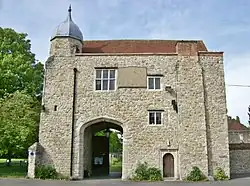 | ||
| The Friars, Main Block | I | Aylesford, Bull Lane | 25 August 1959 | TQ7239658860 51°18′10″N 0°28′18″E / 51.302756°N 0.47168537°E | 1070570 |  | Q17530220 | ||
| Shrine of Our Lady of Mount Carmel and St Simon Stock | II* | Aylesford, Aylesford Priory | 23 September 2016 | TQ7243858895 51°18′11″N 0°28′20″E / 51.303057°N 0.47230417°E | 1437906 | .jpg) | |||
| Granary | II | Aylesford, Bull Lane, 10 Yards East of Court Farmhouse | Granary | 25 February 1987 | TQ7279159060 51°18′16″N 0°28′39″E / 51.304433°N 0.47744285°E | 1111780 | Upload Photo | ||
| The Cedars and Wall to North | II | Aylesford, Bull Lane | 1 August 1952 | TQ7279858996 51°18′14″N 0°28′39″E / 51.303856°N 0.47751220°E | 1070572 | Upload Photo | |||
| Church of St Peter and St Paul | I | Aylesford, Church Walk | Church | 25 August 1959 | TQ7293959032 51°18′15″N 0°28′46″E / 51.304136°N 0.47955034°E | 1337029 | .JPG) | Q17530296 | |
| Brassey tomb monument approximately 36 metres north west of Church of St Peter and St Paul | II | Aylesford, Church Walk | 25 February 1987 | TQ7289959063 51°18′16″N 0°28′44″E / 51.304427°N 0.47899210°E | 1070537 | Upload Photo | |||
| Chest tomb approximately 13 metres south east of Church of St Peter and St Paul | II | Aylesford, Church Walk | 25 February 1987 | TQ7296959022 51°18′15″N 0°28′48″E / 51.304037°N 0.47997543°E | 1070575 | Upload Photo | |||
| Chest tomb approximately 14 metres south of chancel of Church of St Peter and St Paul | II | Aylesford, Church Walk | 25 February 1987 | TQ7295759016 51°18′14″N 0°28′47″E / 51.303987°N 0.47980055°E | 1322400 | Upload Photo | |||
| Chest tomb approximately 18 metres south east of Church of St Peter and St Paul | II | Aylesford, Church Walk | 25 February 1987 | TQ7296659016 51°18′14″N 0°28′48″E / 51.303984°N 0.47992953°E | 1363085 | Upload Photo | |||
| Chest tomb approximately 3 metres east of Church of St Peter and St Paul | II | Aylesford, Church Walk | 25 February 1987 | TQ7296059036 51°18′15″N 0°28′47″E / 51.304166°N 0.47985323°E | 1112546 | Upload Photo | |||
| Chest tomb approximately 3 metres east of Church of St Peter and St Paul | II | Aylesford, Church Walk | 25 February 1987 | TQ7296059030 51°18′15″N 0°28′47″E / 51.304112°N 0.47985033°E | 1070576 | Upload Photo | |||
| Chest tomb approximately 3 metres north east of Church of St Peter and St Paul | II | Aylesford, Church Walk | 25 February 1987 | TQ7295859042 51°18′15″N 0°28′47″E / 51.304220°N 0.47982748°E | 1363086 | Upload Photo | |||
| Chest tomb approximately 4 metres south of Church of St Peter and St Paul | II | Aylesford, Church Walk | 25 February 1987 | TQ7294759019 51°18′14″N 0°28′47″E / 51.304017°N 0.47965869°E | 1111754 | Upload Photo | |||
| Chest tomb approximately 4 metres south of Church of St Peter and St Paul | II | Aylesford, Church Walk | 25 February 1987 | TQ7294359019 51°18′14″N 0°28′47″E / 51.304018°N 0.47960137°E | 1337031 | Upload Photo | |||
| Chest tomb approximately 4 metres south of Church of St Peter and St Paul | II | Aylesford, Church Walk | 25 February 1987 | TQ7294059018 51°18′14″N 0°28′46″E / 51.304010°N 0.47955789°E | 1363083 | Upload Photo | |||
| Chest tomb approximately 4 metres south of west tower of Church of St Peter and St Paul | II | Aylesford, Church Walk | 25 February 1987 | TQ7292359016 51°18′14″N 0°28′46″E / 51.303997°N 0.47931329°E | 1070574 | Upload Photo | |||
| Chest tomb approximately 6 metres east of Church of St Peter and St Paul | II | Aylesford, Church Walk | 25 February 1987 | TQ7296659039 51°18′15″N 0°28′48″E / 51.304191°N 0.47994068°E | 1322403 | Upload Photo | |||
| Chest tomb approximately 6 metres south of Church of St Peter and St Paul | II | Aylesford, Church Walk | 25 February 1987 | TQ7294559015 51°18′14″N 0°28′47″E / 51.303982°N 0.47962809°E | 1070573 | Upload Photo | |||
| Chest tomb approximately 6 metres south of west tower of Church of St Peter and St Paul | II | Aylesford, Church Walk | 25 February 1987 | TQ7292259010 51°18′14″N 0°28′45″E / 51.303944°N 0.47929605°E | 1070538 | Upload Photo | |||
| Chest tomb approximately 6 metres south of west tower of Church of St Peter and St Paul | II | Aylesford, Church Walk | 25 February 1987 | TQ7292459010 51°18′14″N 0°28′46″E / 51.303943°N 0.47932472°E | 1336968 | Upload Photo | |||
| Spong tomb monument approximately 14 metres south of Church of St Peter and St Paul | II | Aylesford, Church Walk | 25 February 1987 | TQ7294159014 51°18′14″N 0°28′46″E / 51.303974°N 0.47957028°E | 1363084 | Upload Photo | |||
| Table tomb approximately 3 metres east of Church of St Peter and St Paul | II | Aylesford, Church Walk | 25 February 1987 | TQ7296059028 51°18′15″N 0°28′47″E / 51.304094°N 0.47984936°E | 1322401 | Upload Photo | |||
| Fountain 30 Yards North of Preston Hall | II | Aylesford, Culpeper Road | 19 January 1989 | TQ7279958104 51°17′45″N 0°28′38″E / 51.295842°N 0.47709499°E | 1290321 | Upload Photo | |||
| Preston Hall | II | Aylesford, Culpeper Road | 19 January 1989 | TQ7278658064 51°17′44″N 0°28′37″E / 51.295487°N 0.47688937°E | 1070492 | Upload Photo | |||
| Statues Flanking Entrance 50 Yards South of Preston Hall | II | Aylesford, Culpeper Road | 19 January 1989 | TQ7277957992 51°17′41″N 0°28′36″E / 51.294842°N 0.47675425°E | 1363122 | Upload Photo | |||
| Wall and Gates to Courtyard at Front of Preston Hall | II | Aylesford, Culpeper Road | 19 January 1989 | TQ7280358025 51°17′42″N 0°28′38″E / 51.295131°N 0.47711409°E | 1210705 | Upload Photo | |||
| 1, High Street | II | Aylesford, 1 High Street | 25 February 1987 | TQ7309058969 51°18′13″N 0°28′54″E / 51.303524°N 0.48168383°E | 1070540 | Upload Photo | |||
| 11 and 13, High Street | II | Aylesford, 11 High Street | 25 February 1987 | TQ7304858965 51°18′13″N 0°28′52″E / 51.303501°N 0.48107998°E | 1070542 | Upload Photo | |||
| 15, High Street | II | Aylesford, 15 High Street | 25 February 1987 | TQ7304158965 51°18′13″N 0°28′52″E / 51.303503°N 0.48097966°E | 1070543 | Upload Photo | |||
| Aylesford Village Shop | II | Aylesford, 21 High Street | 25 February 1987 | TQ7301758964 51°18′13″N 0°28′50″E / 51.303502°N 0.48063523°E | 1070544 | Upload Photo | |||
| 23 and 25, High Street | II | Aylesford, 23 and 25 High Street | 25 February 1987 | TQ7301058964 51°18′13″N 0°28′50″E / 51.303504°N 0.48053492°E | 1363108 | Upload Photo | |||
| 24 and 26, High Street | II | Aylesford, 24 and 26 High Street | 25 February 1987 | TQ7300759000 51°18′14″N 0°28′50″E / 51.303828°N 0.48050936°E | 1111805 | Upload Photo | |||
| 27, High Street | II | Aylesford, 27 High Street | 25 February 1987 | TQ7300158965 51°18′13″N 0°28′49″E / 51.303516°N 0.48040642°E | 1336990 | Upload Photo | |||
| 41-55, High Street | II | Aylesford, 41-55 High Street | 1 August 1952 | TQ7294058975 51°18′13″N 0°28′46″E / 51.303624°N 0.47953707°E | 1111801 | Upload Photo | |||
| 44-48, High Street | II | Aylesford, 44-48 High Street | 25 February 1987 | TQ7296658988 51°18′13″N 0°28′48″E / 51.303733°N 0.47991597°E | 1070547 | Upload Photo | |||
| 54-62, High Street | II | Aylesford, 54-62 High Street | 25 February 1987 | TQ7294058989 51°18′14″N 0°28′46″E / 51.303750°N 0.47954385°E | 1336979 | Upload Photo | |||
| 57 and 59, High Street | II | Aylesford, 57 and 59 High Street | 1 August 1952 | TQ7292058970 51°18′13″N 0°28′45″E / 51.303585°N 0.47924802°E | 1363109 | Upload Photo | |||
| 67, High Street | II | Aylesford, 67 High Street | 1 August 1952 | TQ7289958978 51°18′13″N 0°28′44″E / 51.303663°N 0.47895094°E | 1363076 | Upload Photo | |||
| 73, High Street | II | Aylesford, 73 High Street | 1 August 1952 | TQ7286658981 51°18′13″N 0°28′43″E / 51.303700°N 0.47847946°E | 1081537 | Upload Photo | |||
| 75, High Street | II | Aylesford, 75 High Street | 25 February 1987 | TQ7287758984 51°18′13″N 0°28′43″E / 51.303724°N 0.47863856°E | 1070555 | Upload Photo | |||
| 77, 79 and 81 High Street | II | Aylesford, 77, 79 and 81 High Street | 25 February 1987 | TQ7288458986 51°18′13″N 0°28′43″E / 51.303740°N 0.47873985°E | 1081539 | Upload Photo | |||
| 83, High Street | II | Aylesford, 83 High Street | 25 February 1987 | TQ7289458988 51°18′14″N 0°28′44″E / 51.303755°N 0.47888413°E | 1070546 | Upload Photo | |||
| Hengist Restaurant | II | Aylesford, High Street | 25 February 1987 | TQ7305858968 51°18′13″N 0°28′52″E / 51.303525°N 0.48122475°E | 1070541 | Upload Photo | |||
| The Chequers Public House | II* | Aylesford, High Street | 1 August 1952 | TQ7291258977 51°18′13″N 0°28′45″E / 51.303650°N 0.47913676°E | 1111803 | Upload Photo | |||
| The George House | II* | Aylesford, High Street | 1 August 1952 | TQ7297358967 51°18′13″N 0°28′48″E / 51.303542°N 0.48000612°E | 1070545 | Upload Photo | |||
| The Little Gem Public House | II | Aylesford, High Street | 25 August 1959 | TQ7302558963 51°18′13″N 0°28′51″E / 51.303490°N 0.48074940°E | 1363107 | Upload Photo | |||
| Ivy Cottage | II | Aylesford, 290 London Road | 10 April 1974 | TQ7242657937 51°17′40″N 0°28′18″E / 51.294455°N 0.47166975°E | 1070539 | Upload Photo | |||
| 29 and 31 Mackenders Lane | II | Aylesford, 29 and 31 Mackenders Lane | 2 May 1980 | TQ7314260704 51°19′09″N 0°29′00″E / 51.319095°N 0.48327064°E | 1070548 | Upload Photo | |||
| The Red Bull Public House | II | Aylesford, Mackenders Lane | 25 February 1987 | TQ7303660795 51°19′12″N 0°28′54″E / 51.319944°N 0.48179517°E | 1363110 | Upload Photo | |||
| 5, Mill Hall | II | Aylesford, 5 Mill Hall | 25 February 1987 | TQ7205858696 51°18′05″N 0°28′00″E / 51.301385°N 0.46676247°E | 1336981 | Upload Photo | |||
| Aylesford Goods Shed | II | Aylesford, Mill Hall | 8 February 2022 | TQ7195958743 51°18′07″N 0°27′55″E / 51.301837°N 0.46536637°E | 1479200 | Upload Photo | |||
| 22-32, Mount Pleasant | II | Aylesford, 22-32 Mount Pleasant | 25 February 1987 | TQ7309359067 51°18′16″N 0°28′54″E / 51.304404°N 0.48177432°E | 1111809 | Upload Photo | |||
| Arch and Wall to the North of Trinity Court | II | Aylesford, Mount Pleasant | 25 February 1987 | TQ7311759069 51°18′16″N 0°28′56″E / 51.304415°N 0.48211925°E | 1070549 | Upload Photo | |||
| 280, Pratling Street | II | Aylesford, 280 Pralling Street | 25 February 1987 | TQ7430759685 51°18′35″N 0°29′58″E / 51.309585°N 0.49947413°E | 1070550 | Upload Photo | |||
| 300, Pratling Street | II | Aylesford, 300 Pratling Street | 25 February 1987 | TQ7432259788 51°18′38″N 0°29′59″E / 51.310506°N 0.49973943°E | 1186853 | Upload Photo | |||
| 301 and 303, Pratling Street | II | Aylesford, 301 and 303 Pratling Street | 25 February 1987 | TQ7429359773 51°18′37″N 0°29′58″E / 51.310380°N 0.49931644°E | 1363111 | Upload Photo | |||
| Ruins of Great Cossington at Cossington Farm | II | Aylesford, Pratling Street | 25 February 1987 | TQ7476659756 51°18′36″N 0°30′22″E / 51.310083°N 0.50608762°E | 1186850 | Upload Photo | |||
| Former Methodist Church including Sunday School | II | Aylesford, 31 Rochester Road | 2 April 1990 | TQ7319559036 51°18′15″N 0°29′00″E / 51.304094°N 0.48322109°E | 1363141 | Upload Photo | |||
| Anchor Farmhouse | II | Aylesford, Rochester Road | 25 February 1987 | TQ7356759530 51°18′30″N 0°29′20″E / 51.308419°N 0.48879244°E | 1186862 | Upload Photo | |||
| Anchor Oast, Tottington Farm | II | Aylesford, Rochester Road | 20 November 1995 | TQ7355859577 51°18′32″N 0°29′19″E / 51.308844°N 0.48868630°E | 1242668 | Upload Photo | |||
| Barn 150 Yards South of Little Tottington Farmhouse | II | Aylesford, Rochester Road | 25 February 1987 | TQ7396959974 51°18′44″N 0°29′41″E / 51.312285°N 0.49477049°E | 1186864 | Upload Photo | |||
| Cowleaze Farmhouse | II | Aylesford, Rochester Road | 25 February 1987 | TQ7366759850 51°18′41″N 0°29′25″E / 51.311263°N 0.49038137°E | 1363112 | Upload Photo | |||
| Hale Close | II | Aylesford, Rochester Road | 25 February 1987 | TQ7357760932 51°19′16″N 0°29′23″E / 51.321010°N 0.48961768°E | 1070552 | Upload Photo | |||
| Little Culand Farmhouse | II | Aylesford, Rochester Road | 25 February 1987 | TQ7323161301 51°19′28″N 0°29′05″E / 51.324431°N 0.48483645°E | 1070553 | Upload Photo | |||
| Old Mill House | II | Aylesford, Rochester Road | 31 January 2005 | TQ7336259363 51°18′25″N 0°29′09″E / 51.306981°N 0.48577317°E | 1391221 | Upload Photo | |||
| Trinity Court | II* | Aylesford, Rochester Road | 1 August 1952 | TQ7312159048 51°18′15″N 0°28′56″E / 51.304225°N 0.48216639°E | 1298997 | Upload Photo | |||
| Village Pump 10 Yards East of Trinity Court | II | Aylesford, Rochester Road | 25 February 1987 | TQ7313559046 51°18′15″N 0°28′57″E / 51.304203°N 0.48236606°E | 1070551 | Upload Photo | |||
| 460, Station Road | II | Aylesford, 460 Station Road | 25 February 1987 | TQ7284858791 51°18′07″N 0°28′41″E / 51.301999°N 0.47812954°E | 1070554 | Upload Photo | |||
| Aylesford Bridge | I | Aylesford, Station Road | 25 August 1959 | TQ7294158927 51°18′11″N 0°28′46″E / 51.303192°N 0.47952815°E | 1363113 |  | Q17530328 | ||
| Aylesford railway station | II | Aylesford, Station Road | 25 February 1987 | TQ7201158690 51°18′05″N 0°27′58″E / 51.301345°N 0.46608605°E | 1186882 |  | Q2578339 | ||
| Aylesford Signal Box | II | Aylesford, Aylesford Station | Railway station | 12 July 2013 | TQ7205658680 51°18′04″N 0°28′00″E / 51.301241°N 0.46672610°E | 1415110 | Upload Photo | ||
| Former Village School and Rosalind's Cottage | II | Aylesford, Station Road | 25 February 1987 | TQ7289758816 51°18′08″N 0°28′44″E / 51.302209°N 0.47884385°E | 1186870 | Upload Photo |
See also
Notes
- ^ The date given is the date used by Historic England as significant for the initial building or that of an important part in the structure's description.
- ^ Sometimes known as OSGB36, the grid reference is based on the British national grid reference system used by the Ordnance Survey.
- ^ The "List Entry Number" is a unique number assigned to each listed building and scheduled monument by Historic England.