Listed buildings in Hadlow
Hadlow is village and civil parish in Kent, England. It contains 115 listed buildings that are recorded in the National Heritage List for England. Of these two are grade I, nine are grade II* and 111 are grade II.
This list is based on the information retrieved online from Historic England [1] [2] [3].
Listing
| Name | Grade | Location | Type | Completed [note 1] | Date designated | Grid ref.[note 2] Geo-coordinates | Entry number [note 3] | Image | Wikidata |
|---|---|---|---|---|---|---|---|---|---|
| Hadlow War Memorial | II | 13 May 1998 | TQ6398650361 51°13′44″N 0°20′50″E / 51.228881°N 0.34725862°E | 1119743 |  Upload Photo | ||||
| 1 and 2 Easterfield Cottages | II | 1 and 2, Easterfield Cottages | 19 February 1990 | TQ6327848439 51°12′43″N 0°20′11″E / 51.211816°N 0.33625296°E | 1247909 | Upload Photo | |||
| Barn Approximately 30 Metres North of the Poult House | II | Ashes Lane | 19 February 1990 | TQ6117849704 51°13′26″N 0°18′24″E / 51.223778°N 0.30678191°E | 1070462 | Upload Photo | |||
| Farmbuildings Adjoining to North of North Frith Farmhouse Including Long Barn | II | Ashes Lane | 19 February 1990 | TQ6120050523 51°13′52″N 0°18′27″E / 51.231130°N 0.30746478°E | 1070460 | Upload Photo | |||
| Granary Approximately 250 Metres West of North Frith Farmhouse | II | Ashes Lane | 19 February 1990 | TQ6116350546 51°13′53″N 0°18′25″E / 51.231347°N 0.30694563°E | 1236762 | Upload Photo | |||
| Grimbles | II | Ashes Lane | 3 March 1976 | TQ6215649549 51°13′20″N 0°19′15″E / 51.222108°N 0.32070510°E | 1248626 | Upload Photo | |||
| North Frith Farm Oast | II | Ashes Lane | 19 June 1986 | TQ6114650512 51°13′52″N 0°18′24″E / 51.231046°N 0.30668707°E | 1070461 | Upload Photo | |||
| North Frith Farmhouse | II | Ashes Lane | 19 February 1990 | TQ6122150495 51°13′51″N 0°18′28″E / 51.230873°N 0.30775271°E | 1363143 | Upload Photo | |||
| North Frith House | II | Ashes Lane | 17 May 1996 | TQ6083050243 51°13′43″N 0°18′07″E / 51.228719°N 0.30204433°E | 1268478 | Upload Photo | |||
| North Frith House, Gentlemens Bathing Box | II | Ashes Lane | 17 May 1996 | TQ6099650225 51°13′43″N 0°18′16″E / 51.228510°N 0.30441166°E | 1268479 | Upload Photo | |||
| North Frith House, Ladies Bathing Box | II | Ashes Lane | 17 May 1996 | TQ6097550228 51°13′43″N 0°18′15″E / 51.228543°N 0.30411251°E | 1268480 | Upload Photo | |||
| Old Chegs | II | Ashes Lane | 19 February 1990 | TQ6222149579 51°13′20″N 0°19′18″E / 51.222360°N 0.32164866°E | 1070459 | Upload Photo | |||
| The Poult House | II | Ashes Lane | 19 February 1990 | TQ6117449650 51°13′24″N 0°18′24″E / 51.223294°N 0.30670041°E | 1363144 | Upload Photo | |||
| The Rose Revived | II | Ashes Lane | 19 February 1990 | TQ6242949383 51°13′14″N 0°19′28″E / 51.220540°N 0.32453589°E | 1363142 | Upload Photo | |||
| Bournside Farmhouse | II | Blackmans Lane | 19 February 1990 | TQ6318548952 51°12′59″N 0°20′07″E / 51.216452°N 0.33515590°E | 1236784 | Upload Photo | |||
| Oasthouse Approximately 80 Metres North of Bournside Farmhouse | II | Blackmans Lane | 19 February 1990 | TQ6311448993 51°13′01″N 0°20′03″E / 51.216840°N 0.33415883°E | 1363145 | Upload Photo | |||
| Bourne Mill Cottage | II | Carpenters Lane | 23 September 1974 | TQ6274850263 51°13′42″N 0°19′46″E / 51.228355°N 0.32949904°E | 1236788 | Upload Photo | |||
| Costens Park End Cottages | II | Carpenters Lane | 19 February 1990 | TQ6292150947 51°14′04″N 0°19′56″E / 51.234451°N 0.33228532°E | 1363146 | Upload Photo | |||
| Hoath Cottage | II | Carpenters Lane | 19 February 1990 | TQ6296550454 51°13′48″N 0°19′58″E / 51.230009°N 0.33269095°E | 1264431 | Upload Photo | |||
| Hope Farmhouse | II | Carpenters Lane | 20 October 1954 | TQ6285750304 51°13′43″N 0°19′52″E / 51.228692°N 0.33107737°E | 1070463 | Upload Photo | |||
| Spring Place | II* | Carpenters Lane | 20 October 1954 | TQ6279251063 51°14′08″N 0°19′50″E / 51.235530°N 0.33049184°E | 1236819 | Upload Photo | |||
| The Close | II | Carpenters Lane | 19 February 1990 | TQ6327949749 51°13′25″N 0°20′13″E / 51.223586°N 0.33686329°E | 1070464 | Upload Photo | |||
| Bailiffs Cottage | II | Cemetery Lane | 4 February 1992 | TQ6419949881 51°13′28″N 0°21′00″E / 51.224508°N 0.35008677°E | 1248611 | Upload Photo | |||
| 1 Church Street | II | 1, Church Street | 20 October 1954 | TQ6344249788 51°13′26″N 0°20′21″E / 51.223889°N 0.33921322°E | 1070465 |  | |||
| The Old Red House and 2 Church Street | II | Church Street | 20 October 1954 | TQ6342849786 51°13′26″N 0°20′20″E / 51.223875°N 0.33901200°E | 1237321 | Upload Photo | |||
| Church of St Mary | II* | Church Street | 20 October 1954 | TQ6345449714 51°13′24″N 0°20′22″E / 51.223221°N 0.33935120°E | 1070466 |  | Q7590167 | ||
| Balcombe headstone approximately 10 metres south of the nave of the Church of St Mary | II | Church Street | 19 February 1990 | TQ6344649692 51°13′23″N 0°20′21″E / 51.223026°N 0.33922672°E | 1264340 | Upload Photo | |||
| Barton headstone approximately 1 metre south of the nave of the Church of St Mary | II | Church Street | 19 February 1990 | TQ6345949700 51°13′23″N 0°20′22″E / 51.223094°N 0.33941636°E | 1070470 | Upload Photo | |||
| Beeke headstone approximately 17 metres south of the nave of the Church of St Mary | II | Church Street | 19 February 1990 | TQ6344849686 51°13′23″N 0°20′21″E / 51.222971°N 0.33925260°E | 1070471 | Upload Photo | |||
| Carnel chest tomb approximately 2 metres north of the organ loft of the Church of St Mary | II | Church Street | 19 February 1990 | TQ6346649723 51°13′24″N 0°20′22″E / 51.223298°N 0.33952699°E | 1264365 | Upload Photo | |||
| Carnell chest tomb approximately 3.5 metres north of the organ loft of the Church of St Mary | II | Church Street | 19 February 1990 | TQ6346649727 51°13′24″N 0°20′22″E / 51.223334°N 0.33952881°E | 1070468 | Upload Photo | |||
| Carrol headstone approximately 2.5 metres south of the chancel of the Church of St Mary | II | Church Street | 19 February 1990 | TQ6347049696 51°13′23″N 0°20′22″E / 51.223055°N 0.33957192°E | 1070472 | Upload Photo | |||
| Golding chest tomb approximately 2 metres north of the vestry of the Church of St Mary | II | Church Street | 19 February 1990 | TQ6347149719 51°13′24″N 0°20′23″E / 51.223261°N 0.33959671°E | 1264370 | Upload Photo | |||
| Group of six Kipping headstones approximately 4 metres south of the nave of the Church of St Mary | II | Church Street | 19 February 1990 | TQ6344949700 51°13′23″N 0°20′21″E / 51.223097°N 0.33927328°E | 1070437 | Upload Photo | |||
| Hodg headstone approximately 9 metres east of the chancel of the Church of St Mary | II | Church Street | 19 February 1990 | TQ6349349702 51°13′23″N 0°20′24″E / 51.223102°N 0.33990373°E | 1264279 | Upload Photo | |||
| Hoppers Memorial approximately 20 metres east south east of the chancel of Church of St Mary | II | Church Street | 19 February 1990 | TQ6350049686 51°13′23″N 0°20′24″E / 51.222956°N 0.33999659°E | 1236918 | Upload Photo | |||
| Illegible chest tomb approximately 17 metres west south west of the tower of the Church of St Mary | II | Church Street | 19 February 1990 | TQ6342349708 51°13′23″N 0°20′20″E / 51.223176°N 0.33890493°E | 1363150 | Upload Photo | |||
| Illegible headstone approximately 15 metres north west of the tower of the Church of St Mary | II | Church Street | 19 February 1990 | TQ6342449734 51°13′24″N 0°20′20″E / 51.223409°N 0.33893108°E | 1070442 | Upload Photo | |||
| Iron railings to north of the churchyard of the Church of St Mary | II | Church Street | 19 February 1990 | TQ6345349735 51°13′24″N 0°20′22″E / 51.223410°N 0.33934646°E | 1264261 | Upload Photo | |||
| Jeke headstone adjacent to south porch of the Church of St Mary | II | Church Street | 19 February 1990 | TQ6344449704 51°13′23″N 0°20′21″E / 51.223134°N 0.33920357°E | 1070475 | Upload Photo | |||
| Lick headstone approximately 10 metres south of the nave of the Church of St Mary | II | Church Street | 19 February 1990 | TQ6345849686 51°13′23″N 0°20′22″E / 51.222968°N 0.33939567°E | 1363169 | Upload Photo | |||
| Lomas headstone approximately 8 metres south of the tower of the Church of St Mary | II | Church Street | 19 February 1990 | TQ6342949698 51°13′23″N 0°20′20″E / 51.223084°N 0.33898622°E | 1070438 | Upload Photo | |||
| Maltings Approximately 10 Metres South West of the Old Farmhouse, Style Place | II | Church Street | 19 February 1990 | TQ6460049003 51°12′59″N 0°21′20″E / 51.216504°N 0.35542146°E | 1237143 | Upload Photo | |||
| May Family vault approximately 26 metres south west of the tower of the Church of St Mary | II | Church Street | 19 February 1990 | TQ6341249701 51°13′23″N 0°20′19″E / 51.223116°N 0.33874436°E | 1363148 | Upload Photo | |||
| Pair of Barton headstones approximately 18 metres south west of the tower of the Church of St Mary | II | Church Street | 19 February 1990 | TQ6341449704 51°13′23″N 0°20′20″E / 51.223143°N 0.33877434°E | 1237035 | Upload Photo | |||
| Pair of Cheesman headstones approximately 2.5 metres north of the organ loft of the Church of St Mary | II | Church Street | 19 February 1990 | TQ6346749722 51°13′24″N 0°20′22″E / 51.223289°N 0.33954084°E | 1070473 | Upload Photo | |||
| Pair of Kibble chest tombs approximately 3 metres west of the tower of the Church of St Mary | II | Church Street | 19 February 1990 | TQ6342749718 51°13′24″N 0°20′20″E / 51.223265°N 0.33896672°E | 1363149 | Upload Photo | |||
| Pair of Wells headstones approximately 2 metres north east of the vestry of the Church of St Mary | II | Church Street | 19 February 1990 | TQ6347949716 51°13′24″N 0°20′23″E / 51.223232°N 0.33970980°E | 1363132 | Upload Photo | |||
| Porter chest tomb approximately 20 metres south south west of the tower of the Church of St Mary | II | Church Street | 19 February 1990 | TQ6341749701 51°13′23″N 0°20′20″E / 51.223115°N 0.33881590°E | 1236945 | Upload Photo | |||
| Rodger chest tomb approximately 2 metres west of the tower of the Church of St Mary | II | Church Street | 19 February 1990 | TQ6342849710 51°13′23″N 0°20′20″E / 51.223193°N 0.33897738°E | 1070469 | Upload Photo | |||
| Row of four James headstones approximately 3.5 metres south of the chancel of the Church of St Mary | II | Church Street | 19 February 1990 | TQ6346949691 51°13′23″N 0°20′22″E / 51.223010°N 0.33955533°E | 1264280 | Upload Photo | |||
| Row of Hodsoll headstones approximately 400mm east of the chancel of the Church of St Mary | II | Church Street | 19 February 1990 | TQ6347549704 51°13′23″N 0°20′23″E / 51.223125°N 0.33964710°E | 1070474 | Upload Photo | |||
| Saxby headstone approximately 3 metres south east of the chancel of the Church of St Mary | II | Church Street | 19 February 1990 | TQ6347749696 51°13′23″N 0°20′23″E / 51.223053°N 0.33967207°E | 1363170 | Upload Photo | |||
| Simmons chest tomb approximately 2.5 metres south of the chancel of the Church of St Mary | II | Church Street | 19 February 1990 | TQ6346249698 51°13′23″N 0°20′22″E / 51.223075°N 0.33945837°E | 1264339 | Upload Photo | |||
| Simmons headstone approximately 17 metres south of the nave of the Church of St Mary | II | Church Street | 19 February 1990 | TQ6344249687 51°13′23″N 0°20′21″E / 51.222982°N 0.33916721°E | 1070440 | Upload Photo | |||
| Cheesman headstone approximately 7 metres east north east of the chancel of the Church of St Mary | II | Church Street | 19 February 1990 | TQ6348949711 51°13′23″N 0°20′23″E / 51.223184°N 0.33985060°E | 1237051 | Upload Photo | |||
| Three Porter headstones approximately 19 metres west of the tower of the Church of St Mary | II | Church Street | 19 February 1990 | TQ6341449715 51°13′24″N 0°20′20″E / 51.223241°N 0.33877935°E | 1070439 | Upload Photo | |||
| Wickersham headstone approximately 17 metres west of the tower of the Church of St Mary | II | Church Street | 19 February 1990 | TQ6342149721 51°13′24″N 0°20′20″E / 51.223293°N 0.33888224°E | 1070441 | Upload Photo | |||
| Yardley Memorial approximately 2.5 metres west of the tower of the Church of St Mary | II | Church Street | 19 February 1990 | TQ6342849714 51°13′24″N 0°20′20″E / 51.223228°N 0.33897920°E | 1070467 | Upload Photo | |||
| South wall to churchyard of the Church of St Mary | II | Church Street | 19 February 1990 | TQ6343149690 51°13′23″N 0°20′20″E / 51.223012°N 0.33901119°E | 1363133 | Upload Photo | |||
| Chancel House and Church House | II | Church Street | 20 October 1954 | TQ6341549757 51°13′25″N 0°20′20″E / 51.223619°N 0.33881279°E | 1236882 | Upload Photo | |||
| Church Place | II | Church Street | 20 October 1954 | TQ6343849764 51°13′25″N 0°20′21″E / 51.223675°N 0.33914506°E | 1363147 | Upload Photo | |||
| Cobblestones | II | Church Street | 20 October 1954 | TQ6344649776 51°13′26″N 0°20′21″E / 51.223780°N 0.33926499°E | 1264412 | Upload Photo | |||
| Goldhill House | II | Court Lane | 19 February 1990 | TQ6359548027 51°12′29″N 0°20′26″E / 51.208024°N 0.34059963°E | 1363135 | Upload Photo | |||
| Stables Approximately 45 Metres West of the Old Farmhouse | II | Court Lane | 19 February 1990 | TQ6455049001 51°12′59″N 0°21′17″E / 51.216501°N 0.35470527°E | 1070445 | Upload Photo | |||
| The Hermitage | II | Court Lane | 20 October 1954 | TQ6270449431 51°13′15″N 0°19′43″E / 51.220893°N 0.32849206°E | 1247971 | Upload Photo | |||
| The Old Farmhouse | II* | Court Lane | 20 October 1954 | TQ6342848035 51°12′29″N 0°20′18″E / 51.208144°N 0.33821468°E | 1237176 | Upload Photo | |||
| The Old Farmhouse, Style Place Farm (also known as Caxton Place) | II | Gardeners Cottage and The Gables | 19 February 1990 | TQ6460349040 51°13′01″N 0°21′20″E / 51.216836°N 0.35548134°E | 1237130 | Upload Photo | |||
| Hartlake Barn | II | Hartlake Road | 20 September 1976 | TQ6321247499 51°12′12″N 0°20′06″E / 51.203390°N 0.33488162°E | 1363136 | Upload Photo | |||
| Hartlake Cottage Hartlake Farmhouse | II | Hartlake Road | 20 September 1976 | TQ6325447488 51°12′12″N 0°20′08″E / 51.203279°N 0.33547729°E | 1264221 | Upload Photo | |||
| Hartlake Oasthouse and Hartlake Roundels | II | Hartlake Road | 19 February 1990 | TQ6322147612 51°12′16″N 0°20′06″E / 51.204402°N 0.33506169°E | 1237184 | Upload Photo | |||
| The Maltings I and II | II | Hartlake Road | 25 July 1979 | TQ6321749761 51°13′25″N 0°20′10″E / 51.223711°N 0.33598166°E | 1070448 | Upload Photo | |||
| Thompsons Oast and Thompson Roundels | II | Hartlake Road | 19 February 1990 | TQ6337748048 51°12′30″N 0°20′15″E / 51.208275°N 0.33749114°E | 1070446 | Upload Photo | |||
| Commercial House | II | High Street | 20 October 1954 | TQ6336549799 51°13′26″N 0°20′17″E / 51.224010°N 0.33811653°E | 1363137 | Upload Photo | |||
| Corneys | II | High Street | 20 October 1954 | TQ6344649814 51°13′27″N 0°20′21″E / 51.224122°N 0.33928230°E | 1070453 | Upload Photo | |||
| Former Prince of Wales Public House | II | High Street | 19 February 1990 | TQ6320749688 51°13′23″N 0°20′09″E / 51.223058°N 0.33580538°E | 1363138 | Upload Photo | |||
| Gateway to Hadlow Castle | II* | High Street | 20 October 1954 | TQ6335149741 51°13′25″N 0°20′16″E / 51.223493°N 0.33788981°E | 1363139 |  | |||
| Grays House Hadlow Bakery | II | High Street | 20 October 1954 | TQ6332049725 51°13′24″N 0°20′15″E / 51.223358°N 0.33743898°E | 1070450 | Upload Photo | |||
| Hadlow Tower, Hadlow Castle | I | High Street | 17 April 1951 | TQ6341949639 51°13′21″N 0°20′20″E / 51.222557°N 0.33881627°E | 1070451 | 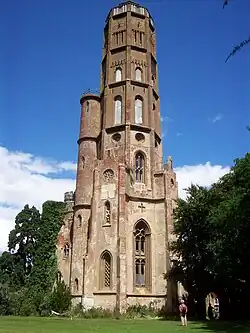 | Q5638005 | ||
| Lime Tree House | II | High Street | 20 October 1954 | TQ6338049803 51°13′27″N 0°20′18″E / 51.224042°N 0.33833297°E | 1237199 | Upload Photo | |||
| Little Corneys | II | High Street | 20 October 1954 | TQ6344549808 51°13′27″N 0°20′21″E / 51.224068°N 0.33926526°E | 1070454 | Upload Photo | |||
| Natal House | II | High Street | 20 October 1954 | TQ6328349703 51°13′23″N 0°20′13″E / 51.223171°N 0.33689958°E | 1237241 | Upload Photo | |||
| North Lodge | II* | High Street | 20 October 1954 | TQ6336049750 51°13′25″N 0°20′17″E / 51.223571°N 0.33802267°E | 1237277 | Upload Photo | |||
| Oasthouse Approximately 8 Metres North West of Spring House | II | High Street | 19 February 1990 | TQ6316049729 51°13′24″N 0°20′07″E / 51.223440°N 0.33515156°E | 1264209 | Upload Photo | |||
| Ranges Round the Stable Yard West of Hadlow Tower, Hadlow Castle | II* | High Street | 19 February 1990 | TQ6343649674 51°13′22″N 0°20′21″E / 51.222867°N 0.33907544°E | 1237300 | Upload Photo | |||
| South Lodge | II* | High Street | 20 October 1954 | TQ6334049733 51°13′24″N 0°20′16″E / 51.223424°N 0.33772878°E | 1237249 | Upload Photo | |||
| Spring Cottage | II | High Street | 19 February 1990 | TQ6318349716 51°13′24″N 0°20′08″E / 51.223316°N 0.33547473°E | 1264196 | Upload Photo | |||
| Spring House | II | High Street | 19 February 1990 | TQ6317549714 51°13′24″N 0°20′07″E / 51.223301°N 0.33535936°E | 1070449 | Upload Photo | |||
| The High House | II | High Street | 19 February 1990 | TQ6499849341 51°13′10″N 0°21′41″E / 51.219426°N 0.36127039°E | 1070443 | Upload Photo | |||
| The Pharmacy | II | High Street | 20 October 1954 | TQ6341449790 51°13′26″N 0°20′20″E / 51.223915°N 0.33881351°E | 1070452 | Upload Photo | |||
| Walnut Tree Cottage | II | High Street | 19 February 1990 | TQ6341049841 51°13′28″N 0°20′20″E / 51.224375°N 0.33877951°E | 1070447 | Upload Photo | |||
| The Terrace | II | 5, Maidstone Road | 19 February 1990 | TQ6348549870 51°13′29″N 0°20′24″E / 51.224614°N 0.33986583°E | 1247881 | Upload Photo | |||
| Appledale Cottage and wall to left | II | Maidstone Road | 19 April 1985 | TQ6413650999 51°14′04″N 0°20′59″E / 51.234570°N 0.34969705°E | 1070697 | Upload Photo | |||
| Former barn 18 metres to the south-west of Goose Green Farmhouse | II | Maidstone Road | 19 April 1985 | TQ6460050962 51°14′03″N 0°21′23″E / 51.234104°N 0.35632037°E | 1363035 | Upload Photo | |||
| Former oast house and granary 45 metres north-east of Goose Green Farmhouse | II | Maidstone Road | 19 April 1985 | TQ6468650995 51°14′04″N 0°21′27″E / 51.234376°N 0.35756626°E | 1070694 | Upload Photo | |||
| Goose Green Farmhouse | II | Maidstone Road | 1 August 1952 | TQ6464150981 51°14′03″N 0°21′25″E / 51.234263°N 0.35691584°E | 1070695 | Upload Photo | |||
| Hadlow Manor Hotel | II | Maidstone Road | 19 April 1985 | TQ6449150945 51°14′02″N 0°21′17″E / 51.233983°N 0.35475269°E | 1070698 | Upload Photo | |||
| Hazel House | II | Maidstone Road | 19 April 1985 | TQ6435851060 51°14′06″N 0°21′10″E / 51.235055°N 0.35290207°E | 1070696 | Upload Photo | |||
| James House Including Garden Walls Adjoining to Rear | II | Maidstone Road | 20 October 1954 | TQ6360050252 51°13′41″N 0°20′30″E / 51.228013°N 0.34168549°E | 1070455 | Upload Photo | |||
| Paris Farmhouse | II | Maidstone Road | 19 April 1985 | TQ6411351010 51°14′05″N 0°20′58″E / 51.234676°N 0.34937293°E | 1363036 | Upload Photo | |||
| North Lodge | II | Shipbourne Road | 18 May 1987 | TQ5982150733 51°14′00″N 0°17′16″E / 51.233404°N 0.28782409°E | 1247885 | Upload Photo | |||
| The Thatch Cottage | II | Shipbourne Road | 19 February 1990 | TQ5976550423 51°13′50″N 0°17′13″E / 51.230635°N 0.28688453°E | 1070456 | Upload Photo | |||
| Animal House and Stables Approximately 35 Metres West of the Old Farmhouse | II | Style Place, Court Lane | 19 February 1990 | TQ6455949022 51°13′00″N 0°21′17″E / 51.216687°N 0.35484365°E | 1264249 | Upload Photo | |||
| Barn Approximately 35 Metres North West of the Old Farmhouse, Style Place | II | Style Place, Court Lane | 19 February 1990 | TQ6455549040 51°13′01″N 0°21′17″E / 51.216850°N 0.35479468°E | 1237154 | Upload Photo | |||
| Outbuilding Approximately 40 Metres South West of the Old Farmhouse | II | Style Place, Court Lane | 19 February 1990 | TQ6460048985 51°12′59″N 0°21′19″E / 51.216342°N 0.35541320°E | 1070444 | Upload Photo | |||
| Pump House Approximately 25 Metres South East of the Old Farmhouse | II | Style Place, Court Lane | 19 February 1990 | TQ6463549023 51°13′00″N 0°21′21″E / 51.216674°N 0.35593132°E | 1363134 | Upload Photo | |||
| Barn Approximately 4 Metres South of Tithe Ward Farmhouse | II | Three Elm Lane | 19 February 1990 | TQ6339248359 51°12′40″N 0°20′16″E / 51.211065°N 0.33784722°E | 1363158 | Upload Photo | |||
| Barnes Place | I | Three Elm Lane | 20 October 1954 | TQ6459248116 51°12′31″N 0°21′18″E / 51.208537°N 0.35490032°E | 1363161 | Upload Photo | |||
| Barnes Street Farmhouse | II | Three Elm Lane | 19 February 1990 | TQ6470848111 51°12′30″N 0°21′24″E / 51.208459°N 0.35655716°E | 1070421 | Upload Photo | |||
| Cartshed and Stables Approximately 15 Metres West of Goldhill Mill | II | Three Elm Lane | 19 February 1990 | TQ6360848458 51°12′43″N 0°20′28″E / 51.211893°N 0.34098197°E | 1363159 | Upload Photo | |||
| Easterfield Farmhouse | II | Three Elm Lane | 19 February 1990 | TQ6334048453 51°12′43″N 0°20′14″E / 51.211924°N 0.33714618°E | 1363140 | Upload Photo | |||
| Golden Green Mission Church | II | Three Elm Lane | 19 February 1990 | TQ6376448252 51°12′36″N 0°20′35″E / 51.209997°N 0.34311944°E | 1070418 | Upload Photo | |||
| Goldhill Mill | II | Three Elm Lane | 20 October 1954 | TQ6363548457 51°12′43″N 0°20′29″E / 51.211876°N 0.34136772°E | 1070417 | Upload Photo | |||
| Hadlow Place | II* | Three Elm Lane | 20 October 1954 | TQ6293748218 51°12′36″N 0°19′53″E / 51.209928°N 0.33127493°E | 1070457 | Upload Photo | |||
| Hadlow Place Farmhouse | II | Three Elm Lane | 19 February 1990 | TQ6240148103 51°12′33″N 0°19′25″E / 51.209047°N 0.32355615°E | 1247903 | Upload Photo | |||
| Poplar Court | II* | Three Elm Lane | 20 October 1954 | TQ6457348176 51°12′33″N 0°21′17″E / 51.209082°N 0.35465606°E | 1070420 | Upload Photo | |||
| Poplar Farm Oast | II | Three Elm Lane | 19 February 1990 | TQ6453448205 51°12′34″N 0°21′15″E / 51.209354°N 0.35411153°E | 1070419 | Upload Photo | |||
| The Barn | II | Three Elm Lane | 19 February 1990 | TQ6455048162 51°12′32″N 0°21′16″E / 51.208963°N 0.35432068°E | 1363160 | Upload Photo | |||
| The Bell Public House | II | Three Elm Lane | 29 January 1990 | TQ6374148290 51°12′37″N 0°20′34″E / 51.210345°N 0.34280779°E | 1070422 | Upload Photo | |||
| Tithe Ward Farmhouse | II | Three Elm Lane | 19 February 1990 | TQ6338948377 51°12′40″N 0°20′16″E / 51.211227°N 0.33781250°E | 1070416 | Upload Photo | |||
| Faulkners Oast | II | Tonbridge Road | 11 May 1973 | TQ6222148908 51°12′59″N 0°19′17″E / 51.216331°N 0.32134531°E | 1263865 | Upload Photo | |||
| Garden Walls Approximately 17 Metres South East of the Hermitage | II | Tonbridge Road | 19 February 1990 | TQ6275349410 51°13′14″N 0°19′45″E / 51.220690°N 0.32918358°E | 1363162 | Upload Photo |
See also
- Grade I listed buildings in Tonbridge and Malling
- Grade II* listed buildings in Tonbridge and Malling
Notes
- ^ The date given is the date used by Historic England as significant for the initial building or that of an important part in the structure's description.
- ^ Sometimes known as OSGB36, the grid reference is based on the British national grid reference system used by the Ordnance Survey.
- ^ The "List Entry Number" is a unique number assigned to each listed building and scheduled monument by Historic England.