Mount Grono
| Mount Grono | |
|---|---|
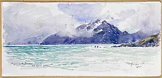 Approach to Doubtful Sound with Mount Grosnez (1875) by W. M. Hodgkins | |
| Highest point | |
| Elevation | 1,196 m (3,924 ft) |
| Coordinates | 45°15′54″S 166°57′06″E / 45.26500°S 166.95167°E |
| Naming | |
| Etymology | Named for John Grono |
| Native name | Te Paparoa-o-Tū (Māori) |
| Defining authority | New Zealand Geographic Board |
| Geography | |
.png) Mount Grono Location in New Zealand | |
| Country | New Zealand |
| Region | Southland Region |
| District | Southland District |
Mount Grono (Māori: Te Paparoa-o-Tū), previously spelled Mount Groznoz,[1] is a 1,196-metre (3,924 ft) peak on Secretary Island,[2] part of New Zealand's Fiordland National Park. It was named for early 19th century sealer John Grono.[3]
Mount Grono is the highest peak in New Zealand's main island chain outside of the North and South Islands.
References
- ^ "Mount Grono". NZ Gazetteer. LINZ. Retrieved 1 April 2024.
- ^ "Mount Grono, Southland – NZ Topo Map". NZ Topo Map. Land Information New Zealand. Retrieved 30 March 2024.
- ^ Owen, Rhodri (1 March 2013). "Wales and the Welsh on the world map after the age of expansion". BBC News. Retrieved 30 March 2024.