Sant'Arsenio
Sant'Arsenio | |
|---|---|
| Comune di Sant'Arsenio | |
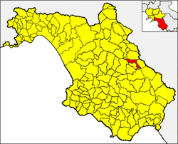 Sant'Arsenio within the Province of Salerno | |
Location of Sant'Arsenio | |
 Sant'Arsenio Location of Sant'Arsenio in Italy  Sant'Arsenio Sant'Arsenio (Campania) | |
| Coordinates: 40°28′14″N 15°28′59″E / 40.47056°N 15.48306°E | |
| Country | Italy |
| Region | Campania |
| Province | Province of Salerno (SA) |
| Area | |
• Total | 20 km2 (8 sq mi) |
| Elevation | 448 m (1,470 ft) |
| Population (June 2006)[2] | |
• Total | 2,714 |
| • Density | 140/km2 (350/sq mi) |
| Demonym | Santarsenesi |
| Time zone | UTC+1 (CET) |
| • Summer (DST) | UTC+2 (CEST) |
| Postal code | 84037 |
| Dialing code | 0975 |
| Patron saint | Sant'Arsenio |
| Saint day | 19 Luglio |
| Website | Official website |
Sant'Arsenio is a town and comune in the Province of Salerno in the Campania region of south-western Italy, located about 180 km southeast of Naples and about 76 km southeast of Salerno. As of 30 June 2006, it had a population of 2,714 (1,309 men and 1,405 women) and an area of 20 km2.[3]
Geography
Sant'Arsenio borders the following municipalities: Atena Lucana (SA), Corleto Monforte (SA), Polla (SA), San Pietro al Tanagro (SA), San Rufo (SA) and Teggiano (SA).
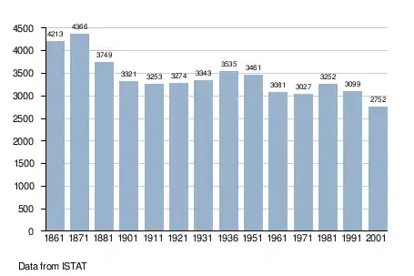
Demographic evolution
See also
References
- ^ "Superficie di Comuni Province e Regioni italiane al 9 ottobre 2011". Italian National Institute of Statistics. Retrieved 16 March 2019.
- ^ "Popolazione Residente al 1° Gennaio 2018". Italian National Institute of Statistics. Retrieved 16 March 2019.
- ^ All demographics and other statistics: Italian statistical institute Istat.
External links
![]() Media related to Sant'Arsenio at Wikimedia Commons
Media related to Sant'Arsenio at Wikimedia Commons
- (in Italian) Sant'Arsenio official website