Santa Rosa Department, Guatemala
Santa Rosa Department Departmento de Santa Rosa | |
|---|---|
  Dock in La Avellana  Central park | |
 Flag  Coat of arms | |
 Santa Rosa | |
| Coordinates: 14°16′42″N 90°18′00″W / 14.27833°N 90.30000°W | |
| Country | |
| Capital | Cuilapa |
| Largest settlement | Chiquimulilla |
| Municipalities | 14 |
| Government | |
| • Type | Departmental |
| Area | |
| 2,295 km2 (886 sq mi) | |
| Highest elevation | 1,330 m (4,360 ft) |
| Lowest elevation | 214 m (702 ft) |
| Population (2018)[1] | |
| 396,607 | |
| • Density | 170/km2 (450/sq mi) |
| • Urban | 184,212 |
| • Ethnicities | Ladino Xinca |
| • Religions | Roman Catholicism Evangelicalism |
| Time zone | UTC-6 |
| ISO 3166 code | GT-SR |


Santa Rosa (Spanish pronunciation: [ˈsanta ˈrosa]) is a department in Guatemala. The capital is Cuilapa.
History
1913 earthquake
On Saturday 8 March 1913, a magnitude 6.4 earthquake hit Santa Rosa, destroying its department capital, Cuilapa.[2] Both the initial quake and the after shocks destroyed a lot of private homes, and also the cathedral and the prison, leaving behind significant human losses; similar destruction occurred at Barberena, Cerro Redondo, Llano Grande and El Zapote.[2] Fraijanes, Pueblo Nuevo Viñas, Coatepeque and Jalpatagua were also affected.[2] Around Cuilapa, there were landslides and road blockades, and even a long crack was reported at Los Esclavos hill.[2]
Municipalities
- Barberena
- Casillas
- Chiquimulilla
- Cuilapa
- Guazacapán
- Nueva Santa Rosa
- Oratorio
- Pueblo Nuevo Viñas
- San Juan Tecuaco
- San Rafael Las Flores
- Santa Cruz Naranjo
- Santa María Ixhuatán
- Santa Rosa de Lima
- Taxisco[3]
Geography
| Type | Name | Location |
|---|---|---|
| Rivers | Negro, Los Achiotes, Tapalapa, Los Vados, San Antonio, Las Cañas, La Plata, Utapa, Amapa, El Panal, Las Marías, El Amarillo, Aguacinapa, Las Margaritas, Utema, Urayala | Santa Rosa Department |
| Paso Hondo River | ||
| María Linda | Border with Escuintla Department | |
| Los Esclavos River | Cuilapa, Mataquescuintla | |
| Canal de Chiquimulilla | Chiquimulillal| | |
| Ojiveros creek | ||
| Paso Caballos creek | ||
| Ponds | Ayarza | Casillas and San Rafael Las Flores |
| Ixpaco | Ixpaco Village, Pueblo Nuevo Viñas | |
| Ojo de Agua | Nueva Santa Rosa | |
| Laguna Pereira | Santa Rosa de Lima | |
| Laguna El Pino | Barberena and Santa Cruz Naranjo | |
| La Palmilla | Taxisco | |
| Tamarindo Viejo | La Avellana, Taxisco |
Culture
Municipal fairs
| Municipality | Days | In honor of |
|---|---|---|
| Barberena | 1 to 6 January | Virgen de la Merced |
| Casillas | 12 to 16 January | Esquipulas Black Christ |
| Chiquimulilla | 30 April to 4 May | Holy Cross |
| Cuilapa | 24 to 25 December | Baby Jesus |
| 1 to 8 de August | Señor de los Portentos | |
| Guazacapán | 6 to 11 December | Immaculate Conception of the Blessed Virgin Mary |
| Nueva Santa Rosa | 12 to 18 November,(variable) | Cristo Rey |
| Oratorio | 28 February to 3 Marzo | Holy Family |
| Pueblo Nuevo Viñas | 18 to 23 January | Esquipulas Black Christ |
| San Juan Tecuaco | 22 to 26 January | Saint John the Baptist |
| San Rafael Las Flores | 22 to 26 October | Saint Raphael Archangel |
| Santa Cruz Naranjo | 1 to 5 May | Holy Cross |
| Santa María Ixhuatán | 13 to 17 December | Virgin Mary |
| Santa Rosa de Lima | 27 to 31 August | Santa Rosa de Lima |
| Taxisco | 12 to 18 January | Esquipulas Black Christ |
Tourism
| Attraction | Name | Location |
|---|---|---|
| Ponds | Ayarza | Casillas and San Rafael Las Flores |
| El Pino | Cerinal, Barberena and Santa Cruz Naranjo | |
| Ixpaco | Tecuamburro, Pueblo Nuevo Viñas | |
| Tamarindo Viejo | La Avellana, Taxisco | |
| Volcanoes | Tecuamburro | Tecuamburro |
| Jumaytepeqe | Nueva Santa Rosa | |
| Cruz Quemada | Ixhuatán | |
| Cerro Redondo | Cerinal and Santa Cruz Naranjo | |
| Colonial monuments | "Los Esclavos" colonial bridge | Cuilapa |
| Colonial parish and Santa Rosa de Lima Temple | Cuilapa | |
| Jumaytepeqe Colonial Catholic Church | Nueva Santa Rosa | |
| La Ermita worship center | Nueva Santa Rosa | |
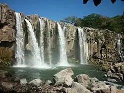
| Waterfalls | Los Chorritos | Espitia Real, Nueva Santa Rosa |
| El Inamo | Estanzuelas, Nueva Santa Rosa | |
| Las Margaritas Falls | Tecuaco, Oratorio and Ixhuatán | |
| Osmawal warefal | Tecuamburro | |
| Caves | Los Serafines Cave | Santa Cruz Naranjo |
| Cave of El Común | Jumaytepeqe, Nueva Santa Rosa | |
| La Eduvijes Cave | Santa Rosa de Lima | |
| Beaches | Las Lisas, La Bocabarra and Chapetón | Chiquimulilla |
| Hawaii and Monterrico | Monterrico, Guatemala | |
| Archeological sites | ||
| Casas Viejas, Los Cerritos, Santa María Los Ujuxtales, Colinas de San Osmardín and Santa Clara | Chiquimulilla | |
| Ixpaco | Pueblo Nuevo Viñas | |
| Arada Nueva | Oratorio | |
| El Jobo y Tacuilula | Taxisco |
Geographic location
Places adjacent to Santa Rosa Department, Guatemala | ||||||||||||||||
|---|---|---|---|---|---|---|---|---|---|---|---|---|---|---|---|---|
| ||||||||||||||||
See also
Notes and references
References
- ^ Citypopulation.de Population of departments in Guatemala
- ^ a b c d Ambraseys & Adams 2001, pp. 72–73
- ^ a b c d SEGEPLAN n.d.
Bibliography
- Ambraseys, Nicholas; Adams, Robin A. (2001). The Seismicity of Central America; a descriptive catalogue 1898-1995. World Scientific. p. 309. ISBN 9781860942440.
- SEGEPLAN (n.d.). "Municipios del departamento de Santa Rosa". SEGEPLAN (in Spanish). Guatemala. Archived from the original on July 7, 2015. Retrieved 30 October 2015.
