Tennie
Tennie | |
|---|---|
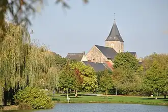 The lake and the church of Sainte-Corneille and Saint-Cyprien | |
Location of Tennie | |
 Tennie  Tennie | |
| Coordinates: 48°06′29″N 0°04′29″W / 48.1081°N 0.0747°W | |
| Country | France |
| Region | Pays de la Loire |
| Department | Sarthe |
| Arrondissement | Mamers |
| Canton | Loué |
| Intercommunality | Champagne Conlinoise et Pays de Sillé |
| Government | |
| • Mayor (2020–2026) | Michel Patry[1] |
Area 1 | 33.13 km2 (12.79 sq mi) |
| Population (2022)[2] | 1,017 |
| • Density | 31/km2 (80/sq mi) |
| Demonym(s) | Tennisien, Tennisienne |
| Time zone | UTC+01:00 (CET) |
| • Summer (DST) | UTC+02:00 (CEST) |
| INSEE/Postal code | 72351 /72240 |
| Elevation | 84–189 m (276–620 ft) |
| 1 French Land Register data, which excludes lakes, ponds, glaciers > 1 km2 (0.386 sq mi or 247 acres) and river estuaries. | |
Tennie (French pronunciation: [teni]) is a commune in the Sarthe department in the region of Pays de la Loire in north-western France.
Geography
The village lies in the middle of the commune, on the left bank of the Vègre, which flows southwestward through the commune.
See also
References
- ^ "Répertoire national des élus: les maires". data.gouv.fr, Plateforme ouverte des données publiques françaises (in French). 2 December 2020.
- ^ "Populations de référence 2022" (in French). The National Institute of Statistics and Economic Studies. 19 December 2024.
Wikimedia Commons has media related to Tennie.