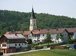
Thurmansbang
Thurmansbang | |
|---|---|
 Thurmansbang | |
 Coat of arms | |
Location of Thurmansbang within Freyung-Grafenau district  | |
 Thurmansbang  Thurmansbang | |
| Coordinates: 48°46′N 13°19′E / 48.767°N 13.317°E | |
| Country | Germany |
| State | Bavaria |
| Admin. region | Niederbayern |
| District | Freyung-Grafenau |
| Municipal assoc. | |
| Government | |
| • Mayor (2024–30) | Stefan Wagner[1] (CSU) |
| Area | |
• Total | 32.95 km2 (12.72 sq mi) |
| Elevation | 494 m (1,621 ft) |
| Population (2024-12-31)[2] | |
• Total | 2,570 |
| • Density | 78/km2 (200/sq mi) |
| Time zone | UTC+01:00 (CET) |
| • Summer (DST) | UTC+02:00 (CEST) |
| Postal codes | 94169 |
| Dialling codes | 08504 |
| Vehicle registration | FRG |
| Website | Offizielle Homepage |
Thurmansbang is a municipality in the district of Freyung-Grafenau in Bavaria in Germany.
References
- ^ Liste der ersten Bürgermeister/Oberbürgermeister in kreisangehörigen Gemeinden, Bayerisches Landesamt für Statistik. Retrieved 13 June 2024.
- ^ "Gemeinden, Kreise und Regierungsbezirke in Bayern, Einwohnerzahlen am 31. Dezember 2024; Basis Zensus 2022" [Municipalities, counties, and administrative districts in Bavaria; Based on the 2022 Census] (CSV) (in German). Bayerisches Landesamt für Statistik.
Towns and municipalities in Freyung-Grafenau | ||
|---|---|---|