Windberg (Freital)
| Windberg | |
|---|---|
 | |
| Highest point | |
| Elevation | 353 m (1,158 ft) |
| Coordinates | 50°59′49″N 13°39′39″E / 50.99694°N 13.66083°E |
| Geography | |
| Parent range | Döhlen Basin |
| Geology | |
| Rock age | Rotliegendes |
| Mountain type | conglomerate with hard coal seams |

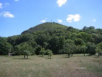
The Windberg (353 m above NN) is a hill in the borough of Freital near Dresden in the German federal state of Saxony. It is the town's Hausberg or local hill.
Geomorphology and natural features
The Windberg has a striking silhouette, visible from afar. Its narrow northwestern slope opens out into a long, broad and thickly wooded plateau. The hill has been designated as a nature reserve and protected area since 1967 due to its near-natural woodland and rich flora and fauna. Its tectonic cleft cavern, known as the Windbergspalte,[1] is the deepest cave in Saxony with a depth of 44 metres (144 ft).
Gallery
-
 Section of an 1895 overview map with the Windberg
 -
 1930 topographical map of the Windberg with contours
 -
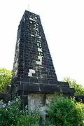 King Albert Monument on the Windberg
 -
 View from Freital-Wurgwitz of the Windberg
References
- ^ Sächsischer Höhlenkataster Nr. 5047/EG-12
Sources
- Haus der Heimat Freital (Hg.): Der Windberg, Freital 1986
External links
Wikimedia Commons has media related to Naturschutzgebiet Windberg.