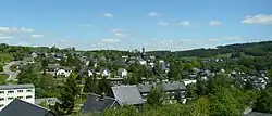
Wurzbach
Wurzbach | |
|---|---|
 | |
 Coat of arms | |
Location of Wurzbach within Saale-Orla-Kreis district  | |
 Wurzbach  Wurzbach | |
| Coordinates: 50°27′50″N 11°32′12″E / 50.46389°N 11.53667°E | |
| Country | Germany |
| State | Thuringia |
| District | Saale-Orla-Kreis |
| Subdivisions | 7 |
| Government | |
| • Mayor (2023–29) | Guido Kant-von der Recke[1] |
| Area | |
• Total | 72.32 km2 (27.92 sq mi) |
| Elevation | 525 m (1,722 ft) |
| Population (2024-12-31)[2] | |
• Total | 2,864 |
| • Density | 40/km2 (100/sq mi) |
| Time zone | UTC+01:00 (CET) |
| • Summer (DST) | UTC+02:00 (CEST) |
| Postal codes | 07343 |
| Dialling codes | 036652 |
| Vehicle registration | SOK |
| Website | www.wurzbach.de |
Wurzbach (German pronunciation: [ˈvʊʁt͡sˌbax] ⓘ) is a town in the Saale-Orla-Kreis district, in southern Thuringia, Germany. It is situated 33 kilometres (21 mi) southeast of Saalfeld, and 45 kilometres (28 mi) northwest of Hof.
History
Within the German Empire (1871-1918), Wurzbach was part of the Principality of Reuss-Gera.
Photos
-
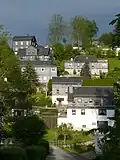 Homes "An der Sormitz"
 -
 Town park
 -
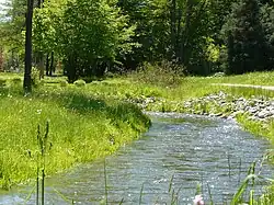 Sormitz (town park)
 -
 WurzBachHaus
 -
 Church and houses, slate-faced.
 -
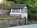 "Garden shed"
 -
 Tower (painted by Michael Fischer-Art)
 -
 Station
References
- ^ Gewählte Bürgermeister - aktuelle Landesübersicht, Freistaat Thüringen. Retrieved 25 June 2024.
- ^ "Bevölkerung der Gemeinden vom Thüringer Landesamt für Statistik" (in German). Thüringer Landesamt für Statistik.
External links
Wikimedia Commons has media related to Wurzbach.
- Official website
 (in German)
