Skály (Strakonice District)
Skály | |
|---|---|
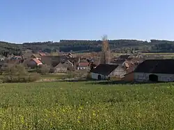 View from the north | |
_Flag.jpg) Flag _CoA.png) Coat of arms | |
 Skály Location in the Czech Republic | |
| Coordinates: 49°11′0″N 13°59′34″E / 49.18333°N 13.99278°E | |
| Country | |
| Region | South Bohemian |
| District | Strakonice |
| First mentioned | 1334 |
| Area | |
• Total | 5.06 km2 (1.95 sq mi) |
| Elevation | 498 m (1,634 ft) |
| Population (2025-01-01)[1] | |
• Total | 77 |
| • Density | 15/km2 (39/sq mi) |
| Time zone | UTC+1 (CET) |
| • Summer (DST) | UTC+2 (CEST) |
| Postal code | 386 01 |
| Website | www |
Skály is a municipality and village in Strakonice District in the South Bohemian Region of the Czech Republic. It has about 80 inhabitants.
Skály lies approximately 12 kilometres (7 mi) south-east of Strakonice, 42 km (26 mi) north-west of České Budějovice, and 106 km (66 mi) south of Prague.
Demographics
| Year | Pop. | ±% |
|---|---|---|
| 1869 | 211 | — |
| 1880 | 260 | +23.2% |
| 1890 | 223 | −14.2% |
| 1900 | 184 | −17.5% |
| 1910 | 200 | +8.7% |
| 1921 | 199 | −0.5% |
| 1930 | 191 | −4.0% |
| 1950 | 153 | −19.9% |
| 1961 | 145 | −5.2% |
| 1970 | 109 | −24.8% |
| 1980 | 100 | −8.3% |
| 1991 | 77 | −23.0% |
| 2001 | 81 | +5.2% |
| 2011 | 66 | −18.5% |
| 2021 | 70 | +6.1% |
| Source: Censuses[2][3] | ||
References
- ^ "Population of Municipalities – 1 January 2025". Czech Statistical Office. 2025-05-16.
- ^ "Historický lexikon obcí České republiky 1869–2011" (in Czech). Czech Statistical Office. 2015-12-21.
- ^ "Population Census 2021: Population by sex". Public Database. Czech Statistical Office. 2021-03-27.
External links
Wikimedia Commons has media related to Skály (Strakonice District).