Le Boupère
Le Boupère | |
|---|---|
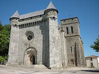 Fortified church of Saint-Pierre, in Le Boupère | |
.svg.png) Coat of arms | |
Location of Le Boupère | |
 Le Boupère  Le Boupère | |
| Coordinates: 46°47′44″N 0°55′31″W / 46.7956°N 0.9253°W | |
| Country | France |
| Region | Pays de la Loire |
| Department | Vendée |
| Arrondissement | Fontenay-le-Comte |
| Canton | Chantonnay |
| Intercommunality | Pays de Pouzauges |
| Government | |
| • Mayor (2020–2026) | Anne Bizon[1] |
Area 1 | 43.48 km2 (16.79 sq mi) |
| Population (2022)[2] | 3,170 |
| • Density | 73/km2 (190/sq mi) |
| Time zone | UTC+01:00 (CET) |
| • Summer (DST) | UTC+02:00 (CEST) |
| INSEE/Postal code | 85031 /85510 |
| Elevation | 67–155 m (220–509 ft) |
| 1 French Land Register data, which excludes lakes, ponds, glaciers > 1 km2 (0.386 sq mi or 247 acres) and river estuaries. | |
Le Boupère (French pronunciation: [lə bupɛʁ]) is a commune in the Vendée department in the Pays de la Loire region in western France.
Geography
The river Lay forms all of the commune's southern border.
Population
| Year | Pop. | ±% p.a. |
|---|---|---|
| 1968 | 2,523 | — |
| 1975 | 2,762 | +1.30% |
| 1982 | 2,892 | +0.66% |
| 1990 | 2,832 | −0.26% |
| 1999 | 2,764 | −0.27% |
| 2007 | 2,856 | +0.41% |
| 2012 | 3,070 | +1.46% |
| 2017 | 3,150 | +0.52% |
| Source: INSEE[3] | ||
See also
References
- ^ "Répertoire national des élus: les maires". data.gouv.fr, Plateforme ouverte des données publiques françaises (in French). 9 August 2021.
- ^ "Populations de référence 2022" (in French). The National Institute of Statistics and Economic Studies. 19 December 2024.
- ^ Population en historique depuis 1968, INSEE
Wikimedia Commons has media related to Le Boupère.