Saint-Cyr-des-Gâts
Saint-Cyr-des-Gâts | |
|---|---|
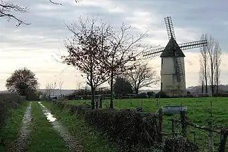 The windmill in Saint-Cyr-des-Gâts | |
Location of Saint-Cyr-des-Gâts | |
 Saint-Cyr-des-Gâts  Saint-Cyr-des-Gâts | |
| Coordinates: 46°34′12″N 0°53′00″W / 46.57°N 0.8833°W | |
| Country | France |
| Region | Pays de la Loire |
| Department | Vendée |
| Arrondissement | Fontenay-le-Comte |
| Canton | La Châtaigneraie |
| Intercommunality | Pays de Fontenay-Vendée |
| Government | |
| • Mayor (2020–2026) | Francis Riviere[1] |
Area 1 | 21.08 km2 (8.14 sq mi) |
| Population (2022)[2] | 543 |
| • Density | 26/km2 (67/sq mi) |
| Time zone | UTC+01:00 (CET) |
| • Summer (DST) | UTC+02:00 (CEST) |
| INSEE/Postal code | 85205 /85410 |
| Elevation | 49–132 m (161–433 ft) |
| 1 French Land Register data, which excludes lakes, ponds, glaciers > 1 km2 (0.386 sq mi or 247 acres) and river estuaries. | |
Saint-Cyr-des-Gâts (French pronunciation: [sɛ̃ siʁ de ɡa]) is a commune in the Vendée department in the Pays de la Loire region in western France.
Geography
The river Smagne forms all of the commune's southern border.
See also
References
- ^ "Répertoire national des élus: les maires". data.gouv.fr, Plateforme ouverte des données publiques françaises (in French). 9 August 2021.
- ^ "Populations de référence 2022" (in French). The National Institute of Statistics and Economic Studies. 19 December 2024.
Wikimedia Commons has media related to Saint-Cyr-des-Gâts.