Pellefigue
Pellefigue | |
|---|---|
 The road into Pellefigue | |
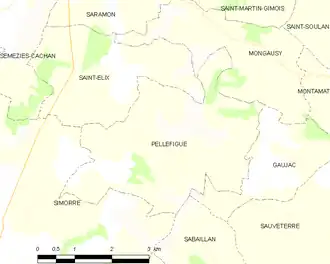
Location of Pellefigue | |
 Pellefigue  Pellefigue | |
| Coordinates: 43°28′31″N 0°47′37″E / 43.4753°N 0.7936°E | |
| Country | France |
| Region | Occitania |
| Department | Gers |
| Arrondissement | Auch |
| Canton | Val de Save |
| Government | |
| • Mayor (2022–2026) | Evelyne Bouas[1] |
Area 1 | 12.81 km2 (4.95 sq mi) |
| Population (2022)[2] | 107 |
| • Density | 8.4/km2 (22/sq mi) |
| Time zone | UTC+01:00 (CET) |
| • Summer (DST) | UTC+02:00 (CEST) |
| INSEE/Postal code | 32309 /32420 |
| Elevation | 182–308 m (597–1,010 ft) (avg. 200 m or 660 ft) |
| 1 French Land Register data, which excludes lakes, ponds, glaciers > 1 km2 (0.386 sq mi or 247 acres) and river estuaries. | |
Pellefigue (French pronunciation: [pɛlfiɡ]; Occitan: Pelahiga) is a commune in the Gers department in southwestern France.
Geography
Population
| Year | Pop. | ±% |
|---|---|---|
| 1962 | 181 | — |
| 1968 | 183 | +1.1% |
| 1975 | 148 | −19.1% |
| 1982 | 129 | −12.8% |
| 1990 | 88 | −31.8% |
| 1999 | 102 | +15.9% |
| 2008 | 120 | +17.6% |
See also
References
- ^ "Répertoire national des élus: les maires" (in French). data.gouv.fr, Plateforme ouverte des données publiques françaises. 4 May 2022.
- ^ "Populations de référence 2022" (in French). The National Institute of Statistics and Economic Studies. 19 December 2024.
Wikimedia Commons has media related to Pellefigue.