Borovnice (Trutnov District)
Borovnice | |
|---|---|
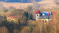 Church of Saint Vitus | |
_Flag.jpg) Flag 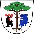 Coat of arms | |
 Borovnice Location in the Czech Republic | |
| Coordinates: 50°30′33″N 15°37′2″E / 50.50917°N 15.61722°E | |
| Country | |
| Region | Hradec Králové |
| District | Trutnov |
| First mentioned | 1382 |
| Area | |
• Total | 9.77 km2 (3.77 sq mi) |
| Elevation | 481 m (1,578 ft) |
| Population (2025-01-01)[1] | |
• Total | 369 |
| • Density | 38/km2 (98/sq mi) |
| Time zone | UTC+1 (CET) |
| • Summer (DST) | UTC+2 (CEST) |
| Postal code | 544 77 |
| Website | www |
Borovnice (Czech pronunciation: [ˈborovɲɪtsɛ]; German: Groß Borowitz) is a municipality and village in Trutnov District in the Hradec Králové Region of the Czech Republic. It has about 400 inhabitants.
Demographics
| Year | Pop. | ±% |
|---|---|---|
| 1869 | 1,443 | — |
| 1880 | 1,305 | −9.6% |
| 1890 | 1,356 | +3.9% |
| 1900 | 1,247 | −8.0% |
| 1910 | 1,210 | −3.0% |
| 1921 | 1,155 | −4.5% |
| 1930 | 1,181 | +2.3% |
| 1950 | 716 | −39.4% |
| 1961 | 723 | +1.0% |
| 1970 | 635 | −12.2% |
| 1980 | 555 | −12.6% |
| 1991 | 439 | −20.9% |
| 2001 | 445 | +1.4% |
| 2011 | 378 | −15.1% |
| 2021 | 342 | −9.5% |
| Source: Censuses[2][3] | ||
References
- ^ "Population of Municipalities – 1 January 2025". Czech Statistical Office. 2025-05-16.
- ^ "Historický lexikon obcí České republiky 1869–2011" (in Czech). Czech Statistical Office. 2015-12-21.
- ^ "Population Census 2021: Population by sex". Public Database. Czech Statistical Office. 2021-03-27.
External links
Wikimedia Commons has media related to Borovnice (Trutnov District).