Longevilles-Mont-d'Or
Longevilles-Mont-d'Or | |
|---|---|
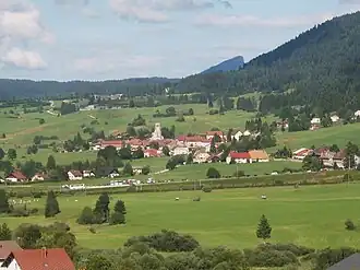 A general view of Longevilles-Mont-d'Or | |
Location of Longevilles-Mont-d'Or | |
 Longevilles-Mont-d'Or  Longevilles-Mont-d'Or | |
| Coordinates: 46°45′16″N 6°19′02″E / 46.7544°N 6.3172°E | |
| Country | France |
| Region | Bourgogne-Franche-Comté |
| Department | Doubs |
| Arrondissement | Pontarlier |
| Canton | Frasne |
| Government | |
| • Mayor (2020–2026) | Claude Jacquemin-Verguet[1] |
Area 1 | 13.25 km2 (5.12 sq mi) |
| Population (2022)[2] | 615 |
| • Density | 46/km2 (120/sq mi) |
| Time zone | UTC+01:00 (CET) |
| • Summer (DST) | UTC+02:00 (CEST) |
| INSEE/Postal code | 25348 /25370 |
| Elevation | 890–1,463 m (2,920–4,800 ft) |
| 1 French Land Register data, which excludes lakes, ponds, glaciers > 1 km2 (0.386 sq mi or 247 acres) and river estuaries. | |
Longevilles-Mont-d'Or (French pronunciation: [lɔ̃ʒvil mɔ̃ dɔʁ]; unofficial also Les Longevilles) is a commune in the Doubs department in the Bourgogne-Franche-Comté region in eastern France.
Geography
The commune is located 10 km (6.2 mi) northeast of Mouthe. The village lies in a valley at the foot of the Mont d'Or, a massif that covers 90% of the territory of the commune.
The commune has views of the Alps and the Swiss plain.
Climate
| Climate data for Longevilles, 1193m (1981−2010 normals, 1992−2015 extremes) | |||||||||||||
|---|---|---|---|---|---|---|---|---|---|---|---|---|---|
| Month | Jan | Feb | Mar | Apr | May | Jun | Jul | Aug | Sep | Oct | Nov | Dec | Year |
| Record high °C (°F) | 16.8 (62.2) | 15.7 (60.3) | 19.8 (67.6) | 22.1 (71.8) | 28.6 (83.5) | 30.8 (87.4) | 30.2 (86.4) | 32.4 (90.3) | 26.7 (80.1) | 26.2 (79.2) | 18.0 (64.4) | 14.6 (58.3) | 32.4 (90.3) |
| Mean daily maximum °C (°F) | 2.2 (36.0) | 3.0 (37.4) | 5.8 (42.4) | 9.4 (48.9) | 14.6 (58.3) | 18.3 (64.9) | 20.1 (68.2) | 19.7 (67.5) | 15.2 (59.4) | 12.1 (53.8) | 5.6 (42.1) | 2.5 (36.5) | 10.7 (51.3) |
| Daily mean °C (°F) | −0.7 (30.7) | −0.3 (31.5) | 2.1 (35.8) | 5.3 (41.5) | 10.2 (50.4) | 13.5 (56.3) | 15.3 (59.5) | 15.1 (59.2) | 11.1 (52.0) | 8.2 (46.8) | 2.5 (36.5) | −0.3 (31.5) | 6.8 (44.3) |
| Mean daily minimum °C (°F) | −3.6 (25.5) | −3.6 (25.5) | −1.6 (29.1) | 1.3 (34.3) | 5.9 (42.6) | 8.7 (47.7) | 10.5 (50.9) | 10.5 (50.9) | 7.0 (44.6) | 4.5 (40.1) | −0.5 (31.1) | −3.1 (26.4) | 3.0 (37.4) |
| Record low °C (°F) | −18.3 (−0.9) | −18.6 (−1.5) | −17.2 (1.0) | −9.6 (14.7) | −3.7 (25.3) | −2.1 (28.2) | 2.4 (36.3) | 1.7 (35.1) | −2.7 (27.1) | −10.2 (13.6) | −13.1 (8.4) | −19.3 (−2.7) | −19.3 (−2.7) |
| Average precipitation mm (inches) | 115.2 (4.54) | 110.6 (4.35) | 112.0 (4.41) | 115.0 (4.53) | 150.7 (5.93) | 130.3 (5.13) | 149.3 (5.88) | 148.7 (5.85) | 133.7 (5.26) | 137.3 (5.41) | 132.7 (5.22) | 140.2 (5.52) | 1,575.7 (62.03) |
| Source: Meteociel[3] | |||||||||||||
Population
| Year | Pop. | ±% |
|---|---|---|
| 1962 | 215 | — |
| 1968 | 248 | +15.3% |
| 1975 | 253 | +2.0% |
| 1982 | 272 | +7.5% |
| 1990 | 323 | +18.8% |
| 1999 | 368 | +13.9% |
| 2008 | 405 | +10.1% |
| 2012 | 445 | +9.9% |
Economy
Winter sports and tourism dominate the economy of the commune. It is one of the six communes that have operated the Métabief Mont-d'Or ski resort since 1970.
See also
References
- ^ "Répertoire national des élus: les maires". data.gouv.fr, Plateforme ouverte des données publiques françaises (in French). 2 December 2020.
- ^ "Populations de référence 2022" (in French). The National Institute of Statistics and Economic Studies. 19 December 2024.
- ^ "Normales et records pour Longevilles (25)". Meteociel. Retrieved 17 April 2024.
External links
Wikimedia Commons has media related to Longevilles-Mont-d'Or.