List of Monuments of National Importance in Chhattisgarh

This is a list of Monuments of National Importance (Asian ) as officially recognized by and available through the website of the Archaeological Survey of India in the state of Chhattisgarh.[1]The monument identifier is a combination of the abbreviation of the subdivision of the list (state, ASI circle) and the numbering as published on the website of the ASI. 46 Monuments of National Importance have been recognized by the ASI in Chhattisgarh.[2] Subsequently one monument from previous list was substituted by another.[3]


List of monuments of national importance
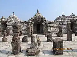
SL. No. Description Location Address District Coordinates Image
N-CT-1 Mahadev Temple including math of Bairagi and Mandapa Narainpur Balodabazar Bhatapara 21°34′34″N 82°22′14″E / 21.57615°N 82.37044°E / 21.57615; 82.37044 (SL. No. N-CT-1)
Mahadev Temple including math of Bairagi and Mandapa

Upload file
N-CT-2 The temple belonging to Mahant Laldass of Sheorinarayan Narainpur Balodabazar Bhatapara 21°34′34″N 82°22′13″E / 21.57621°N 82.3704°E / 21.57621; 82.3704 (SL. No. N-CT-2)
The temple belonging to Mahant Laldass of Sheorinarayan

Upload file
N-CT-3 Mahadeo Temple Bastar Bastar 19°12′44″N 81°55′58″E / 19.21225°N 81.93272°E / 19.21225; 81.93272 (SL. No. N-CT-3)
Mahadeo Temple
Mahadeo Temple

Upload file
N-CT-4 Narayan Temple Narayanpal Bastar 19°11′34″N 81°44′40″E / 19.19277°N 81.74445°E / 19.19277; 81.74445 (SL. No. N-CT-4)
Narayan Temple
Narayan Temple

Upload file
N-CT-5 Old temple of Sita Devi and Sati pillar Deorbija Bemetara 21°40′11″N 81°24′22″E / 21.66974°N 81.40609°E / 21.66974; 81.40609 (SL. No. N-CT-5)
Old temple of Sita Devi and Sati pillar

Upload file
N-CT-6 Ardhanariswara Image Bhairam Deo Gudi Bijapur 18°59′43″N 81°03′27″E / 18.99522°N 81.05763°E / 18.99522; 81.05763 (SL. No. N-CT-6)
Upload Photo
N-CT-7 Bhima-kichak temple[3] Malhar Gaurela-Pendra-Marwahi 22°42′23″N 81°47′02″E / 22.70643°N 81.78381°E / 22.70643; 81.78381 (SL. No. N-CT-7)
Bhima-kichak temple[3]

Upload file
N-CT-8 Narmadeshwar Mahadev Temple Belpan Bilaspur 22°12′41″N 81°52′22″E / 22.2115°N 81.87272°E / 22.2115; 81.87272 (SL. No. N-CT-8)
Upload Photo
N-CT-9 Shiv Temple Gatoura Bilaspur 22°04′08″N 82°15′30″E / 22.06901°N 82.2583°E / 22.06901; 82.2583 (SL. No. N-CT-9)
Upload Photo
N-CT-10 Malhar Fort Malhar Bilaspur 21°53′50″N 82°16′37″E / 21.89726°N 82.27703°E / 21.89726; 82.27703 (SL. No. N-CT-10)
Upload Photo
N-CT-11 Pateleswar Mahadev temple including all ancient remains of other temples close by, together with various sculptures of Brahmanical, Buddhist and Jain pantheons and inscriptions, carved and uncarved stones discovered Malhar Bilaspur 21°53′43″N 82°16′48″E / 21.8954°N 82.28012°E / 21.8954; 82.28012 (SL. No. N-CT-11)
Pateleswar Mahadev temple including all ancient remains of other temples close by, together with various sculptures of Brahmanical, Buddhist and Jain pantheons and inscriptions, carved and uncarved stones discovered

Upload file
N-CT-12 Kanthi Dewal Temple Ratanpur Bilaspur 22°17′20″N 82°09′36″E / 22.28902°N 82.16001°E / 22.28902; 82.16001 (SL. No. N-CT-12)
Kanthi Dewal Temple
Kanthi Dewal Temple

Upload file
N-CT-13 The fine doorway built into the ruined wall beside the north gateway to the fort and the carved stones and images lying about within the boundaries of the village Ratanpur Bilaspur 22°17′07″N 82°10′02″E / 22.28526°N 82.16718°E / 22.28526; 82.16718 (SL. No. N-CT-13)
The fine doorway built into the ruined wall beside the north gateway to the fort and the carved stones and images lying about within the boundaries of the village

Upload file
More images
N-CT-14 Sandstone Shiva temple Deobaloda Durg 21°13′08″N 81°28′25″E / 21.21878°N 81.47348°E / 21.21878; 81.47348 (SL. No. N-CT-14)
Sandstone Shiva temple

Upload file
N-CT-15 Group of temples known as the Rajiva Lochana or Rajim Temples Rajim Gariaband 20°57′50″N 81°52′39″E / 20.96396°N 81.87758°E / 20.96396; 81.87758 (SL. No. N-CT-15)
Group of temples known as the Rajiva Lochana or Rajim Temples

Upload file
N-CT-16 Sita Baree Rajim Gariaband 20°57′48″N 81°52′35″E / 20.9634°N 81.87647°E / 20.9634; 81.87647 (SL. No. N-CT-16)
Sita Baree
Sita Baree

Upload file
N-CT-17 Temple of Ramchandra Rajim Gariaband 20°57′48″N 81°52′44″E / 20.96321°N 81.87885°E / 20.96321; 81.87885 (SL. No. N-CT-17)
Temple of Ramchandra

Upload file
N-CT-18 Ashtabhuji Temple Adbhar Janjgir Champa 21°57′11″N 83°01′29″E / 21.95318°N 83.02484°E / 21.95318; 83.02484 (SL. No. N-CT-18)
Ashtabhuji Temple
Ashtabhuji Temple

Upload file
More images
N-CT-19 Kashigarh fort Kashigarh Janjgir Champa 21°51′10″N 82°47′06″E / 21.85278°N 82.78488°E / 21.85278; 82.78488 (SL. No. N-CT-19)
Upload Photo
N-CT-20 Larger Vishnu temple Janjgir Janjgir Champa 22°00′21″N 82°34′20″E / 22.00596°N 82.57218°E / 22.00596; 82.57218 (SL. No. N-CT-20)
Larger Vishnu temple

Upload file
More images
N-CT-21 Smaller Vishnu Temple Janjgir Janjgir Champa 22°00′23″N 82°34′20″E / 22.00628°N 82.57219°E / 22.00628; 82.57219 (SL. No. N-CT-21)
Smaller Vishnu Temple

Upload file
More images
N-CT-22 Brick Temple of Shabari Kharod Janjgir Champa 21°44′26″N 82°34′41″E / 21.74066°N 82.57807°E / 21.74066; 82.57807 (SL. No. N-CT-22)
Brick Temple of Shabari

Upload file
N-CT-23 Andaldeo Temple Kharod Janjgir Champa 21°44′48″N 82°34′47″E / 21.74675°N 82.57959°E / 21.74675; 82.57959 (SL. No. N-CT-23)
Andaldeo Temple
Andaldeo Temple

Upload file
N-CT-24 Kotmi Fort Kotmi Janjgir Champa 22°01′43″N 82°20′32″E / 22.02868°N 82.34232°E / 22.02868; 82.34232 (SL. No. N-CT-24)
Upload Photo
N-CT-25 Kotgarh Near Bargawan Janjgir Champa 22°03′02″N 82°26′03″E / 22.05058°N 82.43428°E / 22.05058; 82.43428 (SL. No. N-CT-25)
Upload Photo
N-CT-26 Half ruined temple of Kesava Narayan Sheori Narayan Janjgir Champa 21°43′09″N 82°35′25″E / 21.71924°N 82.59023°E / 21.71924; 82.59023 (SL. No. N-CT-26)
Upload Photo
N-CT-27 The Sheorinarayana Temple, together with ruined brick temples in the same compound and the inscription built into the wall of the Chandrachuda temple Sheori Narayan Janjgir Champa 21°43′10″N 82°35′24″E / 21.71937°N 82.58988°E / 21.71937; 82.58988 (SL. No. N-CT-27)
Upload Photo
N-CT-28 Brick mound Gadh Dhanora Kondagaon 20°04′20″N 81°33′18″E / 20.07211°N 81.5549°E / 20.07211; 81.5549 (SL. No. N-CT-28)
Upload Photo
N-CT-29 Chaiturgarh Close to Bagdara Korba 22°30′37″N 82°16′17″E / 22.51027°N 82.27143°E / 22.51027; 82.27143 (SL. No. N-CT-29)
Chaiturgarh
Chaiturgarh

Upload file
N-CT-30 Mahadeo Temple Pali Korba 22°22′23″N 82°19′25″E / 22.37304°N 82.32362°E / 22.37304; 82.32362 (SL. No. N-CT-30)
Mahadeo Temple
Mahadeo Temple

Upload file
N-CT-31 Bankeshwar mahadev temple and mounds of sculptured and unsculptured stones Tuman Korba 22°34′29″N 82°25′20″E / 22.57485°N 82.42223°E / 22.57485; 82.42223 (SL. No. N-CT-31)
Bankeshwar mahadev temple and mounds of sculptured and unsculptured stones

Upload file
N-CT-32 Monuments & Temples Sirpur Mahasamund 21°21′11″N 82°11′12″E / 21.35311°N 82.18671°E / 21.35311; 82.18671 (SL. No. N-CT-32)
Monuments & Temples
Monuments & Temples

Upload file
N-CT-33 Where the monuments are to be found and the mound to the east of Arang Sirpur Mahasamund 21°20′48″N 82°10′55″E / 21.34655°N 82.18207°E / 21.34655; 82.18207 (SL. No. N-CT-33)
Where the monuments are to be found and the mound to the east of Arang

Upload file
N-CT-34 The Pali inscription stone Samarsal Mungeli 22°10′01″N 81°47′23″E / 22.16688°N 81.78982°E / 22.16688; 81.78982 (SL. No. N-CT-34)
Upload Photo
N-CT-35 Bhand Dewal Arang Raipur 21°11′42″N 81°58′10″E / 21.19509°N 81.96957°E / 21.19509; 81.96957 (SL. No. N-CT-35)
Bhand Dewal
Bhand Dewal

Upload file
More images
N-CT-36 Shiv Mandir Gandai-Pandaria Khairagarh-Chhuikhadan-Gandai district 21°39′54″N 81°06′24″E / 21.66503°N 81.10665°E / 21.66503; 81.10665 (SL. No. N-CT-36)
Shiv Mandir
Shiv Mandir

Upload file
N-CT-37 Sita Bengra caves Ramagarh hill Sarguja 22°53′55″N 82°55′50″E / 22.89873°N 82.93055°E / 22.89873; 82.93055 (SL. No. N-CT-37)
Sita Bengra caves
Sita Bengra caves

Upload file
N-CT-38 Jogimara Caves Ramagarh hill Sarguja 22°53′35″N 82°54′19″E / 22.89299°N 82.90523°E / 22.89299; 82.90523 (SL. No. N-CT-38)
Jogimara Caves
Jogimara Caves

Upload file
N-CT-39 Ganesh statues Barsur Dantewada 19°08′03″N 81°22′25″E / 19.13414°N 81.3736°E / 19.13414; 81.3736 (SL. No. N-CT-39)
Ganesh statues
Ganesh statues

Upload file
More images
N-CT-40 Ancient sculpture in Danteswari Temple Barsur Dantewada 19°08′10″N 81°22′41″E / 19.13618°N 81.37804°E / 19.13618; 81.37804 (SL. No. N-CT-40)
Ancient sculpture in Danteswari Temple

Upload file
N-CT-41 Chandraditya Temple Barsur Dantewada 19°08′14″N 81°22′58″E / 19.1371°N 81.38286°E / 19.1371; 81.38286 (SL. No. N-CT-41)
Chandraditya Temple
Chandraditya Temple

Upload file
N-CT-42 Mamabhanjaka Temple Barsur Dantewada 19°08′16″N 81°22′25″E / 19.13764°N 81.37363°E / 19.13764; 81.37363 (SL. No. N-CT-42)
Mamabhanjaka Temple
Mamabhanjaka Temple

Upload file
N-CT-43 Danteswari Devi Temple Dantewada Dantewada 18°53′48″N 81°20′41″E / 18.89667°N 81.34465°E / 18.89667; 81.34465 (SL. No. N-CT-43)
Danteswari Devi Temple

Upload file
N-CT-44 Kamma Memorial or Urasgattta Post Dhilmil Dantewada 18°59′51″N 81°44′04″E / 18.99738°N 81.73444°E / 18.99738; 81.73444 (SL. No. N-CT-44)
Upload Photo
N-CT-45 Megalithic site containing uraskals Gammewada Dantewada 18°48′42″N 81°18′37″E / 18.81175°N 81.31038°E / 18.81175; 81.31038 (SL. No. N-CT-45)
Upload Photo
N-CT-46 Karli Mahadeo Temple Samlur Dantewada 18°58′36″N 81°18′13″E / 18.97673°N 81.30366°E / 18.97673; 81.30366 (SL. No. N-CT-46)
Upload Photo

See also

References

  1. ^ List of Monuments of National Importance as published by the Archaeological Survey of India Archived 2014-06-27 at the Wayback Machine.
  2. ^ "List of Centrally protected Monuments/Sites under the jurisdiction of Chhattisgarh (Raipur Circle) - Archaeological Survey of India" (PDF). asi.nic.in. August 2021. Retrieved 15 May 2023.
  3. ^ a b Directorate of, Culture & Archaeology. "Centrally Protected Monuments, Raipur Circle". Directorate of Culture & Archaeology. Government of Chhattisgarh. Retrieved 31 July 2025.