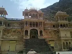
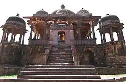
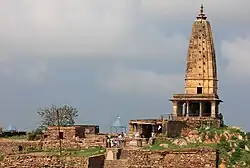
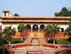
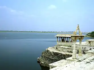
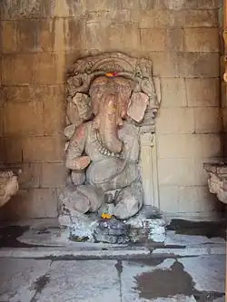
SL. No. Description Location Address District Coordinates Image N-RJ-1 Adhai-Din-ka-Jhonpra Ajmer Ajmer 26°27′19″N 74°37′31″E / 26.45521°N 74.62514°E / 26.45521; 74.62514 (SL. No. N-RJ-1 ) Adhai-Din-ka-Jhonpra More images N-RJ-2 Baori on the Ajmer-Jaipur Road Ajmer Ajmer Upload Photo N-RJ-3 Badshahi Haveli Ajmer Ajmer 26°27′41″N 74°37′52″E / 26.46143°N 74.63117°E / 26.46143; 74.63117 (SL. No. N-RJ-3 ) Badshahi Haveli N-RJ-4 Delhi Gate consisting of one archway Ajmer Ajmer 26°27′44″N 74°37′39″E / 26.46212°N 74.6276°E / 26.46212; 74.6276 (SL. No. N-RJ-4 ) Delhi Gate consisting of one archway N-RJ-5 Gateway of Taragarh Hill Ajmer Ajmer 26°26′37″N 74°37′00″E / 26.44349°N 74.61669°E / 26.44349; 74.61669 (SL. No. N-RJ-5 ) Upload Photo N-RJ-6 Marble Pavilions and Balustrade on the Ana Sagar Bandh and the Ruins of the Marble Hamman behind the Ana Sagar Bandh Ajmer Ajmer 26°28′13″N 74°37′51″E / 26.47017°N 74.63094°E / 26.47017; 74.63094 (SL. No. N-RJ-6 ) Marble Pavilions and Balustrade on the Ana Sagar Bandh and the Ruins of the Marble Hamman behind the Ana Sagar Bandh N-RJ-7 Saheli Bazar Buildings in Daulat Bagh Ajmer Ajmer 26°28′12″N 74°37′56″E / 26.47001°N 74.63215°E / 26.47001; 74.63215 (SL. No. N-RJ-7 ) Upload Photo N-RJ-8 Tomb of Allauddin Khan known as "Sola Khumba" Ajmer Ajmer 26°27′22″N 74°37′38″E / 26.45622°N 74.62717°E / 26.45622; 74.62717 (SL. No. N-RJ-8 ) Tomb of Allauddin Khan known as "Sola Khumba" N-RJ-9 Tomb of Abdulla Khan and his wife Ajmer Ajmer 26°27′09″N 74°38′14″E / 26.45252°N 74.63724°E / 26.45252; 74.63724 (SL. No. N-RJ-9 ) Tomb of Abdulla Khan and his wife N-RJ-10 Tripolia Gate Ajmer Ajmer 26°27′22″N 74°37′36″E / 26.45601°N 74.6268°E / 26.45601; 74.6268 (SL. No. N-RJ-10 ) Tripolia Gate N-RJ-11 Magazine Building in Akbar Fort Ajmer Ajmer 26°27′38″N 74°37′59″E / 26.46069°N 74.63311°E / 26.46069; 74.63311 (SL. No. N-RJ-11 ) Magazine Building in Akbar Fort N-RJ-12 Kos Minar erected by Emperor Akbar Ajmer-Jaipur Road as per ASI Jaipur Circle Ajmer 26°27′22″N 74°37′38″E / 26.45622°N 74.62717°E / 26.45622; 74.62717 (SL. No. N-RJ-12 ) Upload Photo N-RJ-13 Kos Minar erected by Emperor Akbar Ajmer-Jaipur Road Ajmer 26°28′39″N 74°39′28″E / 26.4776°N 74.65776°E / 26.4776; 74.65776 (SL. No. N-RJ-13 ) Upload Photo N-RJ-14 Kos Minar erected by Emperor Akbar Chhatri Ajmer 26°33′58″N 74°42′24″E / 26.566°N 74.70661°E / 26.566; 74.70661 (SL. No. N-RJ-14 ) Upload Photo N-RJ-15 Sarai Chhatri Ajmer 26°33′49″N 74°42′51″E / 26.56355°N 74.71425°E / 26.56355; 74.71425 (SL. No. N-RJ-15 ) Upload Photo N-RJ-16 Kos Minar erected by Emperor Akbar Chugra Ajmer 26°29′27″N 74°40′35″E / 26.49082°N 74.67626°E / 26.49082; 74.67626 (SL. No. N-RJ-16 ) Upload Photo N-RJ-17 Kos Minar erected by Emperor Akbar Hoshiara Ajmer 26°36′44″N 74°44′32″E / 26.61215°N 74.74218°E / 26.61215; 74.74218 (SL. No. N-RJ-17 ) Upload Photo N-RJ-18 Kos Minar erected by Emperor Akbar Hoshiara Ajmer 26°38′15″N 74°45′18″E / 26.63762°N 74.7549°E / 26.63762; 74.7549 (SL. No. N-RJ-18 ) Upload Photo N-RJ-19 Kos Minar erected by Emperor Akbar Kayad Ajmer 26°32′30″N 74°41′30″E / 26.54163°N 74.69173°E / 26.54163; 74.69173 (SL. No. N-RJ-19 ) Upload Photo N-RJ-20 Kos Minar erected by Emperor Akbar Kayampura Ajmer 26°35′16″N 74°43′30″E / 26.58764°N 74.72506°E / 26.58764; 74.72506 (SL. No. N-RJ-20 ) Upload Photo N-RJ-21 Mahal Badshahi Pushkar Ajmer 26°29′05″N 74°33′17″E / 26.48479°N 74.55461°E / 26.48479; 74.55461 (SL. No. N-RJ-21 ) Mahal Badshahi N-RJ-22 Bhandasar Jain Temple Bikaner Bikaner 28°00′17″N 73°18′03″E / 28.00475°N 73.30075°E / 28.00475; 73.30075 (SL. No. N-RJ-22 ) Bhandasar Jain Temple N-RJ-23 Jain Temple of Suswani Goddess Morkhana Maa Suswani Mata Temple Morkhana , Morkhana , Rajasthan 334202 Bikaner 27°45′03″N 73°32′27″E / 27.750730°N 73.540786°E / 27.750730; 73.540786 (SL. No. N-RJ-23 ) Jain Temple of Suswani Goddess N-RJ-24 Siva temple and ruins Arthuna Banswara 23°29′35″N 74°06′01″E / 23.49313°N 74.10036°E / 23.49313; 74.10036 (SL. No. N-RJ-24 ) Siva temple and ruins N-RJ-25 Mahakal and two other temples Bijolia Bhilwara 25°09′24″N 75°19′41″E / 25.15672°N 75.32793°E / 25.15672; 75.32793 (SL. No. N-RJ-25 ) Mahakal and two other temples N-RJ-26 Rock Inscriptions (12th century) Bijolia Bhilwara Upload Photo N-RJ-27 Rock Inscriptions within the Paraswanath Temple compound (12th century) Bijolia Bhilwara 25°08′58″N 75°20′15″E / 25.14948°N 75.33761°E / 25.14948; 75.33761 (SL. No. N-RJ-27 ) Upload Photo N-RJ-28 Ancient temple known as Kaneriki Putali Kharipur village Bhilwara 25°08′31″N 75°13′34″E / 25.14186°N 75.22607°E / 25.14186; 75.22607 (SL. No. N-RJ-28 ) Upload Photo N-RJ-29 Wall Paintings of Hardoti School in the palace (Garh Palace ) Bundi Bundi 25°26′57″N 75°38′08″E / 25.44917°N 75.63567°E / 25.44917; 75.63567 (SL. No. N-RJ-29 ) Wall Paintings of Hardoti School in the palace (Garh Palace ) More images N-RJ-30 Ancient Mound Nainwa Bundi Upload Photo N-RJ-31 Ancient Mound Keshwarai Patan Bundi Upload Photo N-RJ-32 Ghateshwar Temple (part of Baroli temple complex ) Badoli, Rawatbhata Chittaurgarh 24°57′30″N 75°35′36″E / 24.95846°N 75.59334°E / 24.95846; 75.59334 (SL. No. N-RJ-32 ) Ghateshwar Temple (part of Baroli temple complex )More images N-RJ-33 Kund (part of Baroli temple complex ) Badoli, Rawatbhata Chittaurgarh 24°57′29″N 75°35′32″E / 24.95812°N 75.59233°E / 24.95812; 75.59233 (SL. No. N-RJ-33 ) Upload Photo N-RJ-34 Shrinagar Chawri (part of Baroli temple complex ) Badoli, Rawatbhata Chittaurgarh 24°57′31″N 75°35′37″E / 24.95866°N 75.59348°E / 24.95866; 75.59348 (SL. No. N-RJ-34 ) Shrinagar Chawri (part of Baroli temple complex ) More images N-RJ-35 Temple of Ashtamata (part of Baroli temple complex ) Badoli, Rawatbhata Chittaurgarh 24°57′30″N 75°35′36″E / 24.95846°N 75.59334°E / 24.95846; 75.59334 (SL. No. N-RJ-35 ) Upload Photo N-RJ-36 Temple of Ganesh (part of Baroli temple complex ) Badoli, Rawatbhata Chittaurgarh 24°57′30″N 75°35′36″E / 24.95846°N 75.59334°E / 24.95846; 75.59334 (SL. No. N-RJ-36 ) Temple of Ganesh (part of Baroli temple complex ) More images N-RJ-37 Temple of Sheshashayan (part of Baroli temple complex ) Badoli, Rawatbhata Chittaurgarh 24°57′30″N 75°35′36″E / 24.95846°N 75.59334°E / 24.95846; 75.59334 (SL. No. N-RJ-37 ) Upload Photo N-RJ-38 Temple of Shiv and Kund (part of Baroli temple complex ) Badoli, Rawatbhata Chittaurgarh 24°57′30″N 75°35′36″E / 24.95846°N 75.59334°E / 24.95846; 75.59334 (SL. No. N-RJ-38 ) Temple of Shiv and Kund (part of Baroli temple complex ) More images N-RJ-39 Temple of Trimurti (part of Baroli temple complex ) Badoli, Rawatbhata Chittaurgarh 24°57′30″N 75°35′36″E / 24.95846°N 75.59334°E / 24.95846; 75.59334 (SL. No. N-RJ-39 ) Temple of Trimurti (part of Baroli temple complex ) More images N-RJ-40 Temple of Vamanavatar known as Narad Temple (part of Baroli temple complex ) Badoli, Rawatbhata Chittaurgarh 24°57′30″N 75°35′36″E / 24.95846°N 75.59334°E / 24.95846; 75.59334 (SL. No. N-RJ-40 ) Upload Photo N-RJ-41 Fort of Chittaur as a whole (Chittorgarh Fort ) Chittaur Chittaurgarh 24°53′11″N 74°38′49″E / 24.8863°N 74.647°E / 24.8863; 74.647 (SL. No. N-RJ-41 ) Fort of Chittaur as a whole (Chittorgarh Fort ) More images N-RJ-42 Mahanal Temple & Math Menal Chittaurgarh 25°05′35″N 75°10′20″E / 25.09313°N 75.17223°E / 25.09313; 75.17223 (SL. No. N-RJ-42 ) Mahanal Temple & Math N-RJ-43 Ancient Ruins Nagari Chittaurgarh 24°58′12″N 74°40′46″E / 24.9701°N 74.67957°E / 24.9701; 74.67957 (SL. No. N-RJ-43 ) Ancient Ruins N-RJ-44 Hathiwada enclosure with inscription together with adjacent in S.Plot No. 301 (archaeological site of the Hathibada Inscription ) Nagari Chittaurgarh 24°58′33″N 74°41′20″E / 24.97574°N 74.6889°E / 24.97574; 74.6889 (SL. No. N-RJ-44 ) Hathiwada enclosure with inscription together with adjacent in S.Plot No. 301 (archaeological site of the Hathibada Inscription ) More images N-RJ-45 Ancient site and remains together with adjacent area comprised in whole of survey no.2 : 991,992,993,994/1,994/3, 995,996,997,998,999,1000 and 1002. Nagari Chittaurgarh 24°58′14″N 74°40′49″E / 24.97058°N 74.68036°E / 24.97058; 74.68036 (SL. No. N-RJ-45 ) Upload Photo N-RJ-46 Archaeological sites & remains Nilodh / Jeora Chittaurgarh Upload Photo N-RJ-47 Ancient Mounds Badopal Hanumangarh Upload Photo N-RJ-48 Ancient Mounds Bhadrakali Hanumangarh Upload Photo N-RJ-49 Ancient Mounds Dhokal Hanumangarh Upload Photo N-RJ-50 Fort Bhatner Hanumangarh Hanumangarh 29°35′08″N 74°19′31″E / 29.58567°N 74.3253°E / 29.58567; 74.3253 (SL. No. N-RJ-50 ) Fort Bhatner More images N-RJ-51 Three Ancient Mounds Kalibangan Hanumangarh Three Ancient Mounds N-RJ-52 Ancient Mounds Manak Hanumangarh Upload Photo N-RJ-53 Ancient Mounds Munda Hanumangarh Upload Photo N-RJ-54 Ancient Mounds Peer Sultan Hanumangarh Upload Photo N-RJ-55 Ancient Mounds Pilibangan Hanumangarh Upload Photo N-RJ-56 Two Ancient Mounds Mathula Ganganagar Upload Photo N-RJ-57 Ancient Mounds Chak 86 Ganganagar Upload Photo N-RJ-58 Ancient Mounds Bhannar Thedi Ganganagar Upload Photo N-RJ-59 Ancient Mounds Binjor Ganganagar Upload Photo N-RJ-60 Ancient Mounds Baror Ganganagar Upload Photo N-RJ-61 Ancient Mounds Rang Mahal Ganganagar Upload Photo N-RJ-62 Ancient Mounds Tarkhanwala Dera Ganganagar Upload Photo N-RJ-63 Jain Temple Inscription Baroda Dungarpur 23°54′13″N 74°03′22″E / 23.90354°N 74.05601°E / 23.90354; 74.05601 (SL. No. N-RJ-63 ) Upload Photo N-RJ-64 Somnath Temple Deo Somnath Dungarpur 23°56′26″N 73°51′41″E / 23.94066°N 73.86152°E / 23.94066; 73.86152 (SL. No. N-RJ-64 ) Somnath Temple N-RJ-65 Buddhist Caves and Pillars Binnayaga (Dag) Jhalawar 24°03′45″N 75°53′37″E / 24.06249°N 75.89348°E / 24.06249; 75.89348 (SL. No. N-RJ-65 ) Buddhist Caves and Pillars N-RJ-66 Caves of Naranjani etc. Binnayaga (Dag) Jhalawar Upload Photo N-RJ-67 Ancient Ruins Dalsanagar (Gangadhar) Jhalawar Upload Photo N-RJ-68 Ancient Ruins Dudhaliya (Dag) Jhalawar Upload Photo N-RJ-69 Buddhist Caves Hathiagor Jhalawar 24°06′39″N 75°51′53″E / 24.11087°N 75.86474°E / 24.11087; 75.86474 (SL. No. N-RJ-69 ) Upload Photo N-RJ-70 Buddhist Caves, Pillars, Idols Kolvi (Dag) Jhalawar 24°00′38″N 75°50′59″E / 24.01066°N 75.84977°E / 24.01066; 75.84977 (SL. No. N-RJ-70 ) Buddhist Caves, Pillars, Idols N-RJ-71 Old Temples near the Chandrabhaga Jhalrapatan Jhalawar 24°31′47″N 76°10′40″E / 24.52969°N 76.17766°E / 24.52969; 76.17766 (SL. No. N-RJ-71 ) Old Temples near the Chandrabhaga N-RJ-72 Ancient Mound[ 3] Abaneri Dausa Upload Photo N-RJ-73 Baori (Chand Baori ) Abaneri Dausa 27°00′26″N 76°36′23″E / 27.00734°N 76.60646°E / 27.00734; 76.60646 (SL. No. N-RJ-73 ) Baori (Chand Baori ) More images N-RJ-74 Harsat Mata ka Mandir Abaneri Dausa 27°00′27″N 76°36′19″E / 27.00757°N 76.60522°E / 27.00757; 76.60522 (SL. No. N-RJ-74 ) Harsat Mata ka Mandir More images N-RJ-75 Banjaron ki Chhatri (containing two pillars similar to railing pillars of Bharhut Stupa) Lalsot Dausa 26°33′43″N 76°19′35″E / 26.56208°N 76.32632°E / 26.56208; 76.32632 (SL. No. N-RJ-75 ) Upload Photo N-RJ-76 Ancient Mound Maheshra Dausa Upload Photo N-RJ-77 Ancient Mound Raniwas Dausa Upload Photo N-RJ-78 Ancient Mound Sikrai Dausa Upload Photo N-RJ-79 Sun Temple(see also S-RJ-118 ) Amber Jaipur 26°59′23″N 75°51′00″E / 26.9898°N 75.84991°E / 26.9898; 75.84991 (SL. No. N-RJ-79 ) Sun Temple(see also S-RJ-118 ) More images N-RJ-80 Jama Masjid Amber Jaipur 26°59′20″N 75°51′22″E / 26.98896°N 75.8562°E / 26.98896; 75.8562 (SL. No. N-RJ-80 ) Jama Masjid More images N-RJ-81 Laxmi Narain's Temple Amber Jaipur 26°59′17″N 75°51′20″E / 26.98808°N 75.85567°E / 26.98808; 75.85567 (SL. No. N-RJ-81 ) Laxmi Narain's Temple More images N-RJ-82 Sri Jagat Siromani ji temple Amber Jaipur 26°59′21″N 75°51′05″E / 26.98905°N 75.85126°E / 26.98905; 75.85126 (SL. No. N-RJ-82 ) Sri Jagat Siromani ji temple More images N-RJ-83 Pundrik ji-ki-Haveli Paintings in a room Brahmpuri Jaipur 26°56′12″N 75°49′30″E / 26.93664°N 75.82494°E / 26.93664; 75.82494 (SL. No. N-RJ-83 ) Upload Photo N-RJ-84 Temple containing Fresco paintings Gulta ji Jaipur 26°55′03″N 75°51′25″E / 26.91755°N 75.85702°E / 26.91755; 75.85702 (SL. No. N-RJ-84 ) Temple containing Fresco paintings N-RJ-85 Excavated Site Sambhar Jaipur Excavated Site N-RJ-86 Excavated Site Bairat Jaipur Excavated Site N-RJ-87 Fort including Ancient Temples (Jaisalmer Fort ) Jaisalmer Jaisalmer 26°54′45″N 70°54′45″E / 26.91245°N 70.9126°E / 26.91245; 70.9126 (SL. No. N-RJ-87 ) Fort including Ancient Temples (Jaisalmer Fort ) More images N-RJ-88 Ancient Site Lodruva Patan Jaisalmer Upload Photo N-RJ-89 Fort (Mandore Fort) Mandore Jodhpur 26°21′13″N 73°01′59″E / 26.35372°N 73.03312°E / 26.35372; 73.03312 (SL. No. N-RJ-89 ) Fort (Mandore Fort) More images N-RJ-90 Ruins of Temples Ganesh-Ganj or Atru Baran 24°52′18″N 76°40′01″E / 24.87165°N 76.667°E / 24.87165; 76.667 (SL. No. N-RJ-90 ) Upload Photo N-RJ-91 Yupa Pillars Badwa Baran 25°05′39″N 76°20′49″E / 25.0942°N 76.34703°E / 25.0942; 76.34703 (SL. No. N-RJ-91 ) Upload Photo N-RJ-92 Temple (12th century) Baran Baran 25°06′09″N 76°31′37″E / 25.10259°N 76.52706°E / 25.10259; 76.52706 (SL. No. N-RJ-92 ) Upload Photo N-RJ-93 Ancient Ruins and Structural Remains Krishnavilas Baran 25°02′09″N 76°44′12″E / 25.03592°N 76.73654°E / 25.03592; 76.73654 (SL. No. N-RJ-93 ) Upload Photo N-RJ-94 Old Temples, Statues and Inscriptions Shargarh Baran 24°42′18″N 76°32′33″E / 24.70508°N 76.54242°E / 24.70508; 76.54242 (SL. No. N-RJ-94 ) Old Temples, Statues and Inscriptions N-RJ-95 Siva Temple and two unpublished Gupta Inscriptions Charchoma Kota 25°05′39″N 76°07′24″E / 25.0942°N 76.12326°E / 25.0942; 76.12326 (SL. No. N-RJ-95 ) Siva Temple and two unpublished Gupta Inscriptions N-RJ-96 Temple, Fort wall and Statues Dara or Mukandara Kota 24°48′53″N 75°59′09″E / 24.8148°N 75.98573°E / 24.8148; 75.98573 (SL. No. N-RJ-96 ) Upload Photo N-RJ-97 Temple with Inscriptions Kanswa Kota 25°08′41″N 75°52′58″E / 25.14478°N 75.88275°E / 25.14478; 75.88275 (SL. No. N-RJ-97 ) Temple with Inscriptions N-RJ-98 Percian Inscriptions in a Baori Alanpur Sawai Madhopur 26°00′01″N 76°21′59″E / 26.0004°N 76.36632°E / 26.0004; 76.36632 (SL. No. N-RJ-98 ) Upload Photo N-RJ-99 Jain Temple Sawai Madhopur Sawai Madhopur 26°00′03″N 76°21′49″E / 26.00073°N 76.36365°E / 26.00073; 76.36365 (SL. No. N-RJ-99 ) Upload Photo N-RJ-100 Ranthambhor Fort Ranthambor Sawai Madhopur 26°01′15″N 76°27′18″E / 26.02075°N 76.45496°E / 26.02075; 76.45496 (SL. No. N-RJ-100 ) Ranthambhor Fort N-RJ-101 Harshnath Temple Sikar Sikar 27°30′00″N 75°10′21″E / 27.49991°N 75.17258°E / 27.49991; 75.17258 (SL. No. N-RJ-101 ) Harshnath Temple N-RJ-102 Bisal Deo ji's Temple Bisalpur Tonk 25°55′38″N 75°27′26″E / 25.92711°N 75.45714°E / 25.92711; 75.45714 (SL. No. N-RJ-102 ) Bisal Deo ji's Temple N-RJ-103 Ancient Mound Bundwali Doongri Tonk Upload Photo N-RJ-104 Ancient Mound Gariagarh (Newai) Tonk Upload Photo N-RJ-105 Devapura Barodia Mounds Jhalia Tonk Upload Photo N-RJ-106 Hathi Bhata Khera Tonk 25°59′35″N 75°55′27″E / 25.99292°N 75.92403°E / 25.99292; 75.92403 (SL. No. N-RJ-106 ) Upload Photo N-RJ-107 Ancient Mound Nagar Tonk Upload Photo N-RJ-108 Excavated Site Nagar Tonk Upload Photo N-RJ-109 Inscription in Fort Nagar Tonk Upload Photo N-RJ-110 Mand Kila Tal Inscription Nagar Tonk Upload Photo N-RJ-111 Yupa Pillars in Bichpuria Temple Nagar Tonk Upload Photo N-RJ-112 Inscription Panwar Tonk Upload Photo N-RJ-113 Excavated Site Rairh (Newai) Tonk Upload Photo N-RJ-114 Kala Pahar Temple Todarai Singh Tonk 26°01′26″N 75°29′08″E / 26.02381°N 75.48562°E / 26.02381; 75.48562 (SL. No. N-RJ-114 ) Upload Photo N-RJ-115 Kalyanrai ji's Temple Todarai Singh Tonk 26°01′33″N 75°29′10″E / 26.02589°N 75.48615°E / 26.02589; 75.48615 (SL. No. N-RJ-115 ) Upload Photo N-RJ-116 Laxmi Narainji's Temple locally known as Gopinathji's Temple Todarai Singh Tonk 26°01′29″N 75°29′08″E / 26.02466°N 75.48561°E / 26.02466; 75.48561 (SL. No. N-RJ-116 ) Upload Photo N-RJ-117 Old Baories locally known as Hadirani-ka-kund Todarai Singh Tonk 26°01′14″N 75°28′43″E / 26.02048°N 75.4785°E / 26.02048; 75.4785 (SL. No. N-RJ-117 ) Upload Photo N-RJ-118 Pipa ji's Temple Todarai Singh Tonk 26°01′19″N 75°29′14″E / 26.02189°N 75.48736°E / 26.02189; 75.48736 (SL. No. N-RJ-118 ) Upload Photo N-RJ-119 Akbar's Chhatri Bayana Bharatpur 26°54′07″N 77°17′21″E / 26.90203°N 77.28914°E / 26.90203; 77.28914 (SL. No. N-RJ-119 ) Upload Photo N-RJ-120 Ancient Fort with its Monuments (Bijai Garh/Bayana Fort ) Bayana Bharatpur 26°53′11″N 77°14′12″E / 26.8864°N 77.23671°E / 26.8864; 77.23671 (SL. No. N-RJ-120 ) Ancient Fort with its Monuments (Bijai Garh/Bayana Fort ) N-RJ-121 Brahmabad Idgah Bayana Bharatpur 26°55′09″N 77°19′00″E / 26.91912°N 77.31653°E / 26.91912; 77.31653 (SL. No. N-RJ-121 ) Upload Photo N-RJ-122 Islam Shah's Gate Bayana Bharatpur 26°55′31″N 77°19′28″E / 26.92536°N 77.32432°E / 26.92536; 77.32432 (SL. No. N-RJ-122 ) Upload Photo N-RJ-123 Jahangir's Gateway Bayana Bharatpur 26°54′30″N 77°17′22″E / 26.90829°N 77.28942°E / 26.90829; 77.28942 (SL. No. N-RJ-123 ) Upload Photo N-RJ-124 Jhajri Bayana Bharatpur 26°54′05″N 77°17′20″E / 26.90143°N 77.28879°E / 26.90143; 77.28879 (SL. No. N-RJ-124 ) Upload Photo N-RJ-125 Saraj Sad-ullah Bayana Bharatpur 26°54′12″N 77°17′23″E / 26.90341°N 77.28974°E / 26.90341; 77.28974 (SL. No. N-RJ-125 ) Upload Photo N-RJ-126 Usa Mandir Bayana Bharatpur 26°54′23″N 77°17′10″E / 26.90628°N 77.28598°E / 26.90628; 77.28598 (SL. No. N-RJ-126 ) Upload Photo N-RJ-127 Lodhi's Minar Bayana Bharatpur 26°54′24″N 77°17′10″E / 26.90661°N 77.28615°E / 26.90661; 77.28615 (SL. No. N-RJ-127 ) Upload Photo N-RJ-128 Delhi Gate outside the Bharatpur Fort Bharatpur Bharatpur 27°13′27″N 77°29′33″E / 27.22416°N 77.49261°E / 27.22416; 77.49261 (SL. No. N-RJ-128 ) Upload Photo N-RJ-129 Fateh Burj near Anah Gate Bharatpur Bharatpur 27°13′23″N 77°30′14″E / 27.22307°N 77.50398°E / 27.22307; 77.50398 (SL. No. N-RJ-129 ) Upload Photo N-RJ-130 Jawahar Burj and Ashtadhatu Gateway inside the Bharatpur Fort (Lohagarh Fort ) Bharatpur Bharatpur 27°13′23″N 77°29′40″E / 27.22315°N 77.49458°E / 27.22315; 77.49458 (SL. No. N-RJ-130 ) Upload Photo N-RJ-131 Moat surrounding the Fort wall (Lohagarh Fort ) Bharatpur Bharatpur 27°13′15″N 77°29′30″E / 27.22079°N 77.49155°E / 27.22079; 77.49155 (SL. No. N-RJ-131 ) Moat surrounding the Fort wall (Lohagarh Fort ) N-RJ-132 Fort walls including Chowburja gate and approach bridges at the Chowburja and Ashtadhatu gates (Lohagarh Fort ) Bharatpur Bharatpur 27°13′01″N 77°29′45″E / 27.21683°N 77.49596°E / 27.21683; 77.49596 (SL. No. N-RJ-132 ) Upload Photo N-RJ-133 Deeg Bhawans (Palace) Deeg Bharatpur 27°28′20″N 77°19′25″E / 27.47223°N 77.32366°E / 27.47223; 77.32366 (SL. No. N-RJ-133 ) Deeg Bhawans (Palace) More images N-RJ-134 Looted gun (at Deeg Fort) Deeg Bharatpur 27°28′21″N 77°19′41″E / 27.47241°N 77.32807°E / 27.47241; 77.32807 (SL. No. N-RJ-134 ) Upload Photo N-RJ-135 Marble Jholla Deeg Bharatpur 27°28′20″N 77°19′26″E / 27.47223°N 77.3239°E / 27.47223; 77.3239 (SL. No. N-RJ-135 ) Marble Jholla More images N-RJ-136 Kaccha Bag Deeg Bharatpur 27°28′24″N 77°19′17″E / 27.4732°N 77.32138°E / 27.4732; 77.32138 (SL. No. N-RJ-136 ) Kaccha Bag N-RJ-137 Chaurasi Khamba temple Kaman Bharatpur 27°39′04″N 77°15′57″E / 27.65122°N 77.26577°E / 27.65122; 77.26577 (SL. No. N-RJ-137 ) Upload Photo N-RJ-138 Ancient Mound Malah Bharatpur Upload Photo N-RJ-139 Ancient Mound Noh Bharatpur Upload Photo N-RJ-140 Colossal image of Yaksha Noh Bharatpur Upload Photo N-RJ-141 Lal Mahal Rupvas Bharatpur 26°59′33″N 77°35′23″E / 26.99239°N 77.58974°E / 26.99239; 77.58974 (SL. No. N-RJ-141 ) Upload Photo N-RJ-142 Shiva temple Neelkanth Alwar 27°14′51″N 76°21′07″E / 27.24744°N 76.35191°E / 27.24744; 76.35191 (SL. No. N-RJ-142 ) Shiva temple N-RJ-143 Ancient site (Bhangarh Fort ) Bhangarh Alwar 27°05′41″N 76°17′29″E / 27.09459°N 76.29129°E / 27.09459; 76.29129 (SL. No. N-RJ-143 ) Ancient site (Bhangarh Fort ) More images N-RJ-144 Ancient Remains Pandupol Alwar 27°19′08″N 76°26′10″E / 27.31878°N 76.4362°E / 27.31878; 76.4362 (SL. No. N-RJ-144 ) Ancient Remains N-RJ-145 Lal Masjid Tijara Alwar 27°55′59″N 76°51′51″E / 27.93303°N 76.8642°E / 27.93303; 76.8642 (SL. No. N-RJ-145 ) Upload Photo N-RJ-146 Ancient Ruins Kalyanpur Udaipur 24°00′31″N 73°45′16″E / 24.00867°N 73.75432°E / 24.00867; 73.75432 (SL. No. N-RJ-146 ) Ancient Ruins N-RJ-147 Sas Bahu Temples Nagda Udaipur 24°44′07″N 73°42′59″E / 24.73519°N 73.71628°E / 24.73519; 73.71628 (SL. No. N-RJ-147 ) Sas Bahu Temples N-RJ-148 Fort of Kumbhalgarh as a whole Kumbhalgarh Rajasamand 25°08′52″N 73°35′00″E / 25.14783°N 73.58332°E / 25.14783; 73.58332 (SL. No. N-RJ-148 ) Fort of Kumbhalgarh as a whole N-RJ-149 Ghat with inscriptions pavilions and Toranas (together with adjacent area comprised in S.Plot No. 344). Nav Chowki Rajsamand Rajasamand 25°04′06″N 73°52′33″E / 25.06839°N 73.87586°E / 25.06839; 73.87586 (SL. No. N-RJ-149 ) Ghat with inscriptions pavilions and Toranas (together with adjacent area comprised in S.Plot No. 344). More images N-RJ-150 Archaeological Sites and Remains Gilund Rajasamand Upload Photo N-RJ-151 Babur's Garden (Charbagh) Dholpur (Jhor) Dholpur 26°41′33″N 77°51′58″E / 26.69262°N 77.86615°E / 26.69262; 77.86615 (SL. No. N-RJ-151 ) Upload Photo N-RJ-152 Jogni-Jogna Temple Dholpur / Sone- ka – Gurja Dholpur Upload Photo N-RJ-153 Shergarh Fort Dholpur Dholpur 26°40′19″N 77°54′07″E / 26.67182°N 77.90199°E / 26.67182; 77.90199 (SL. No. N-RJ-153 ) Shergarh Fort More images N-RJ-154 Wall painting in the palaces of Maharaja Gopal Lal Karauli Karauli 26°29′45″N 77°01′48″E / 26.49572°N 77.02994°E / 26.49572; 77.02994 (SL. No. N-RJ-154 ) Wall painting in the palaces of Maharaja Gopal Lal N-RJ-155 Haldighati (mountain pass) Dara Rajsamand 24°53′06″N 73°41′38″E / 24.88496°N 73.69401°E / 24.88496; 73.69401 (SL. No. N-RJ-155 ) Haldighati (mountain pass) N-RJ-156 Badshahi Bagh Nathdwara Rajsamand 24°54′00″N 73°43′00″E / 24.9001°N 73.71662°E / 24.9001; 73.71662 (SL. No. N-RJ-156 ) Upload Photo N-RJ-157 Chetak Samadhi Raktatalai Rajsamand 24°53′12″N 73°41′34″E / 24.88677°N 73.69266°E / 24.88677; 73.69266 (SL. No. N-RJ-157 ) Chetak Samadhi N-RJ-158 Rakta Talai Tehsil- Nathdwara Rajsamand 24°55′12″N 73°43′14″E / 24.91999°N 73.72051°E / 24.91999; 73.72051 (SL. No. N-RJ-158 ) Upload Photo N-RJ-159 Ruined Palace of Maharana Pratap at Chavand Sarada Udaipur 24°10′39″N 73°48′40″E / 24.17744°N 73.8111°E / 24.17744; 73.8111 (SL. No. N-RJ-159 ) Upload Photo N-RJ-160 Mahal known as Hawa Mahal, Veerpura (Jaisamand) Sarada Udaipur 24°14′19″N 73°57′13″E / 24.23855°N 73.95363°E / 24.23855; 73.95363 (SL. No. N-RJ-160 ) Upload Photo N-RJ-161 Roothi Rani Ka Mahal, Veerpura (Jaisamand) Sarada Udaipur 24°14′34″N 73°57′44″E / 24.24266°N 73.96236°E / 24.24266; 73.96236 (SL. No. N-RJ-161 ) Upload Photo N-RJ-162 Protection of Brahma Temple Pushkar Ajmer 26°29′15″N 74°32′56″E / 26.48742°N 74.54894°E / 26.48742; 74.54894 (SL. No. N-RJ-162 ) Protection of Brahma Temple N-RJ-163 Fortress known as Medhaji-ka-Mahal Jamwa Ramgarh Jaipur 27°01′34″N 76°00′31″E / 27.02609°N 76.00853°E / 27.02609; 76.00853 (SL. No. N-RJ-163 ) Upload Photo .jpg)


.jpg)


.jpg)